
Kakadu National Park is a protected area in the Northern Territory of Australia, 171 km (106 mi) southeast of Darwin. It is a World Heritage Site. Kakadu is also gazetted as a locality, covering the same area as the national park, with 313 people recorded living there in the 2016 Australian census.
Bowling Green Bay is a national park in the City of Townsville and Shire of Burdekin, Queensland, Australia, 1,103 km northwest of Brisbane, and 28 km south of Townsville and 59 km north of Ayr. It is a Ramsar Convention listed site. The park protects diverse range of habitats including the rugged, forested landscape surrounding Mount Elliot and Saddle Mountain as well as coastal estuaries between Cape Cleveland and Cape Bowling Green.

The Dawson Highway is a state highway in Queensland, Australia. It runs for 405 kilometres (252 mi) between Gladstone and Springsure where it terminates. From Gladstone to Rolleston it is signed as State Route 60, and then A7 onwards to Springsure. It continues west for another 247 kilometres (153 mi) as Dawson Developmental Road to Tambo on the Landsborough Highway. North of Springsure, A7 becomes the Gregory Highway.
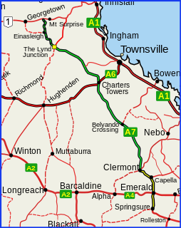
The Gregory Highway is a state highway in Queensland, Australia that serves the major coal-mining centres of Central Queensland. The highway was named after Augustus Gregory, an early explorer.

The Victoria Highway links the Great Northern Highway in Western Australia with the Stuart Highway in the Northern Territory. The highway is a part of the Perth - Darwin National Highway link. It is signed as National Highway 1, and is part of Highway 1, a circular route around the country. It is 555 kilometres (345 mi) long, and most of the route – some 470 kilometres (290 mi) – lies within the Northern Territory. In some areas it runs in parallel with the Northern Territory's Victoria River, from which its name originates.

The Gore Highway is a highway running between Toowoomba and Goondiwindi in Queensland, Australia. Together with Goulburn Valley Highway and Newell Highway, it is a part of the National Highway's Melbourne-Brisbane link. It is signed as National Highway A39.

Pine Creek is a small town in the Katherine region of the Northern Territory, Australia. As at the 2016 Census there were 328 residents of Pine Creek, which is the fourth largest town between Darwin and Alice Springs.

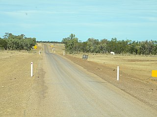
The Arnhem Highway is a 227—kilometre highway in the Northern Territory of Australia. It links the mining town of Jabiru, in Kakadu National Park, to the Stuart Highway at a point 35 kilometres south of Darwin.
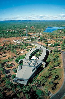
Jabiru is a town in the Northern Territory of Australia. Built in 1982, the town is completely surrounded by Kakadu National Park. At the 2016 census, Jabiru had a population of 1,081. It is named after the black-necked stork often seen in the wetlands and billabongs of Kakadu, which is commonly referred to in Australia as a Jabiru.

The Isis Highway is a state highway in southern Queensland, Australia. The highway is relatively short, and runs for 137 kilometres (85 mi) in a north-east / south-west direction between Bundaberg North and the Burnett Highway at Ban Ban Springs. The Isis Highway links the sugar producing Bundaberg and Fraser Coast regions with the cattle farming districts of the North Burnett.

The Twin Falls is a cascade waterfall on the South Alligator River that descends over the Arnhem Land escarpment within the UNESCO World Heritage–listed Kakadu National Park in the Northern Territory of Australia. In 1980, The Twin Falls area was listed on the now-defunct Register of the National Estate.

Ubirr is a rock formation within the East Alligator region of Kakadu National Park in the Northern Territory of Australia, and is known for its rock art. It consists of a group of rock outcrops on the edge of the Nadab floodplain where there are several natural shelters that have a collection of Aboriginal rock paintings, some of which are many thousands of years old. The art depicts certain creation ancestors as well as animals from the area such as barramundi, catfish, mullet, goannas, long-necked turtles, pig-nosed turtles, rock ringtail possums, and wallabies.
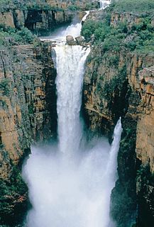
The Jim Jim Falls is a plunge waterfall on the Jim Jim Creek that descends over the Arnhem Land escarpment within the UNESCO World Heritage–listed Kakadu National Park in the Northern Territory of Australia. The Jim Jim Falls area is registered on the Australian National Heritage List.
The Savannah Way is a route of highways and major roads across the tropical savannahs of northern Australia, linking Cairns in Queensland with Broome in Western Australia. Promoted as a self-drive tourist route, it joins Cairns, Normanton, Borroloola, Katherine, Kununurra, Fitzroy Crossing, Derby and Broome. It has been designated by the Queensland Government as a State Strategic Touring Route.

Duncan Road is a generally northeast-southwest former highway in the northeast of Western Australia and northwest of Northern Territory that links the Victoria Highway with Halls Creek. The road, approximately 443 kilometres (275 mi) in length, was designated as National Route 80 from its terminus at Halls Creek through to Nicholson. National Route 80 continued east into the Northern Territory along Buntine Highway, while Duncan Road snakes its way north, crossing the state border numerous times between Buntine Highway and Victoria Highway.

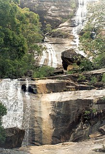
The Gunlom Falls, formerly Waterfall Creek Falls, is a cascading waterfall on the Waterfall Creek located in the Kakadu National Park in the Northern Territory, Australia. The falls are also known as UDP Falls and are perhaps most famous for making an appearance in the movie Crocodile Dundee.
Jabiru Airport is an airport located 1.5 nautical miles northwest of Ranger Uranium Mine and east of Jabiru in the Northern Territory of Australia. Situated within the Kakadu National Park it consists of one runway and five parking spaces for light aircraft such as Cessna 152s. Charter flight operators include AAA Charter, Kakadu Air and North Australian Helicopters.
Dorat Road is a designated state route in the Northern Territory of Australia providing an alternative route to the Stuart Highway from Adelaide River and rejoining north of Hayes Creek, a distance of 65 km (40 mi). The road provides access to tourist attractions including Robin Falls and Douglas-Daly Hot Springs, several World War II heritage locations, and forms part of the road access to Daly River and Wadeye via the Daly River Road which branches from Dorat Road approximately 31 km (19 mi) south of Adelaide River.

The Wills Developmental Road is a road in north-west Queensland running between Julia Creek and Burketown. As of 2016 it is sealed with a total length of 500 kilometres (310 mi). There are no major towns along the entire route, but fuel and supplies are available at the Burke and Wills Roadhouse at Four Ways, and also at Gregory. The Wills Developmental Road joins the Burke Developmental Road for approximately 1.2 kilometres, avoiding a direct crossroads at their intersection. Two major rivers are crossed by the Wills Developmental Road en route, the Cloncurry and the Leichhardt.