The Northern Territory is an Australian territory in the central and central northern regions of Australia. Northern Territory shares its borders with Western Australia to the west, South Australia to the south, and Queensland to the east. To the north, the territory looks out to the Timor Sea, the Arafura Sea and the Gulf of Carpentaria, including Western New Guinea and other islands of the Indonesian archipelago.

Protected areas of Australia include Commonwealth and off-shore protected areas managed by the Australian government, as well as protected areas within each of the six states of Australia and two self-governing territories, the Australian Capital Territory and the Northern Territory, which are managed by the eight state and territory governments.

Uluṟu-Kata Tjuṯa National Park is a protected area in the Northern Territory of Australia. The park is home to both Uluru and Kata Tjuta. It is located 1,943 kilometres (1,207 mi) south of Darwin by road and 440 kilometres (270 mi) south-west of Alice Springs along the Stuart and Lasseter Highways. The park covers 1,326 square kilometres (512 sq mi) and includes the features it is named after: Uluru and, 40 kilometres (25 mi) to its west, Kata Tjuta. The location is listed with UNESCO World Heritage sites for natural and cultural landscape.

Uluru, also known as Ayers Rock and officially gazetted as Uluru / Ayers Rock, is a large sandstone rock formation in the southern part of the Northern Territory in Australia. It lies 335 km (208 mi) south west of the nearest large town, Alice Springs.
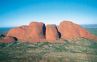
Kata Tjuṯa,, also known as the Olgas, is a group of large, domed rock formations or bornhardts located about 360 km (220 mi) southwest of Alice Springs, in the southern part of the Northern Territory, central Australia. Uluṟu, also known as Ayers Rock, located 25 km (16 mi) to the east, and Kata Tjuṯa form the two major landmarks within the Uluṟu-Kata Tjuṯa National Park. The park is considered sacred to the Aboriginal people of Australia.
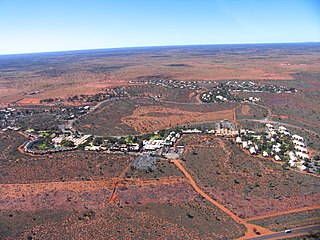
Yulara is a town in the Southern Region of the Northern Territory, Australia. It lies as an unincorporated enclave within MacDonnell Region. At the 2016 census, Yulara had a permanent population of 1,099, in an area of 103.33 square kilometres (39.90 sq mi). It is 18 kilometres (11 mi) by road from world heritage site Uluru and 55 kilometres (34 mi) from Kata Tjuta. It is located in the Northern Territory electorate of Gwoja and the federal electorate of Lingiari.
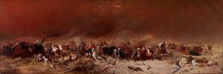
Lasseter's Reef refers to the purported discovery, announced by Harold Bell Lasseter in 1929 and 1930, of a fabulously rich gold deposit in a remote and desolate corner of central Australia. Lasseter's accounts of the find are conflicting and its precise location remains a mystery—if it exists.
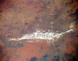
Lake Amadeus is a large salt lake in the southwest corner of Northern Territory of Australia, about 50 kilometres (31 mi) north of Uluru. The smaller Lake Neale is adjacent to the northwest. It is part of the Amadeus Basin that was filled with the erosion products of the Petermann Orogeny.

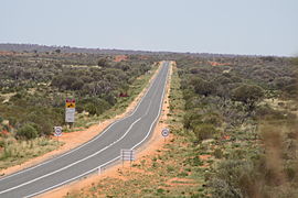
The Victoria Highway links the Great Northern Highway in Western Australia with the Stuart Highway in the Northern Territory. The highway is a part of the Perth - Darwin National Highway link. It is signed as National Highway 1, and is part of Highway 1, a circular route around the country. It is 555 kilometres (345 mi) long, and most of the route – some 470 kilometres (290 mi) – lies within the Northern Territory. In some areas it runs in parallel with the Northern Territory's Victoria River, from which its name originates.

Mutitjulu is an Aboriginal Australian community in the Northern Territory of Australia located at the eastern end of Uluru. It is named after a knee-shaped water-filled rock hole at the base of Uluru, and is located in the Uluru-Kata Tjuta National Park. Its people are traditional owners and joint managers of the park with Parks Australia. At the 2011 census, Mutitjulu had a population of 296, of which 218 (71.2%) were Aboriginal.
The History of the Northern Territory began over 60,000 years ago when Indigenous Australians settled the region. Makassan traders began trading with the indigenous people of the Northern Territory for trepang from at least the 18th century onwards, and possibly 300 years prior to that.

The Great Central Road is a mostly unsealed Australian outback highway that runs 1,126 km (700 mi) from Laverton, Western Australia to Yulara, Northern Territory. It passes through a number of small communities on the way.

Curtin Springs is a pastoral lease operating as a cattle station in the Alice Springs region of the Northern Territory of Australia.

The Carpentaria Highway is a 380-kilometre-long (240 mi) highway, which runs from near Daly Waters to Borroloola in the Northern Territory, Australia. It is a sealed road and is part of National Highway 1. The Highway takes its name from the Gulf of Carpentaria, which it links with the Stuart Highway. The Carpentaria Highway also provides road access to the McArthur River mineral deposits and port facilities at Bing Bong, as well as the isolated community of Borroloola and the popular fishing location at King Ash Bay. Funding for maintenance is provided by the Northern Territory government.
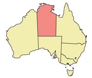
The Northern Territory (NT) occupies the north central part of the continent of Australia. The Northern Territory borders are to the west with Western Australia, the Western Australia border being near the 129° east longitude. The NT to the south with the South Australian border being the 26th parallel south latitude. To the east the NT with the Queensland border along the 138° east longitude.

Australia’s monuments take on many distinct forms, including statues, fountains, natural landmarks and buildings. Whilst some monuments of Australia hold a national significance, many are constructed and maintained by local community groups, and are primarily significant on a local scale. Although Australia’s monuments have many roles, including as tourist attractions, their primary purpose is to “safeguard, prolong or preserve social memory into the future”. This social memory may relate to anything from colonisation to local industry to sports. The monuments of Australia reflect the nation’s social and political history and by memorialising select moments, contribute to shaping how Australian history is told. Although a significant portion of Australia is desert, the population is highly urbanised and the cities contain some noteworthy monuments. These include:
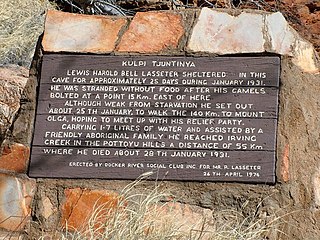
Tjunti is a soakage site near Kaḻṯukatjara, in the Northern Territory of Australia. It is located where the Hull River cuts through the Petermann Ranges, about 36 kilometres (22 mi) to the southeast of Kaḻṯukatjara, 41 km (25 mi) by road along the Tjukaruru Road. Tjunti is known as the site where the famous gold prospector Harold B. Lasseter took refuge on his fatal search for Lasseter's Reef. An outstation was established here in 1977, and belongs to a Pitjantjatjara family.
Malya Teamay is an Aboriginal Australian artist. He is also an administrator of Uluṟu-Kata Tjuṯa National Park, serving as a member of its Board of Management. As an artist, Teamay works for Walkatjara Art Uluṟu. This art centre is part of the Uluṟu–Kata Tjuṯa Cultural Centre located inside the national park. Examples of Teamay's paintings are held in the Queensland Gallery of Modern Art, and the Museum of Victoria.
The Katiti Aboriginal Land Trust is a land trust for a block of land in the southwest of the Northern Territory of Australia located in the locality of Petermann. It was created through the Katiti Land Claim in 1980. The trust's owners include Pitjantjatjara, Yankunytjatjara and Luritja people. The block of land is officially referred to as Northern Territory Portion 1818. It borders the larger Petermann Land Trust area and Uluṟu–Kata Tjuṯa National Park to the north and west, and two pastoral stations to the east and south: Curtin Springs and Mulga Park. The town of Yulara is excluded from the Land Trusts, and sits between the Katiti block and Uluṟu–Kata Tjuṯa National Park.