Sandover Highway

Last updated

Sandover Highway
Northern Territory
Sandover Highway route map.png
Map of central Australia with Sandover Highway (State Route 14) highlighted in red
Coordinates
General information
Type Track
Length 561 km (349 mi)
Route number(s) Australian state route 14.svg State Route 14
Major junctions
Southwest endAustralian state route 12.svg Plenty Highway
Northeast end Lake Nash,
NT/Qld Border
Location(s)
Region Urapuntja
Restrictions
Fuel supply
Facilities Arlparra, Ammaroo Station

The Sandover Highway is an outback unsealed track in the Northern Territory between the Plenty Highway north of Alice Springs and the Northern Territory/Queensland border.

Northern Territory federal territory of Australia

The Northern Territory is an Australian territory in the central and central northern regions of Australia. It shares borders with Western Australia to the west, South Australia to the south, and Queensland to the east. To the north, the territory looks out to the Timor Sea, the Arafura Sea and the Gulf of Carpentaria, including Western New Guinea and other Indonesian islands. The NT covers 1,349,129 square kilometres (520,902 sq mi), making it the third-largest Australian federal division, and the 11th-largest country subdivision in the world. It is sparsely populated, with a population of only 246,700, making it the least-populous of Australia's eight states and major territories, with fewer than half as many people as Tasmania.

Plenty Highway track in the Northern Territory

The Plenty Highway is a 498 kilometre outback mostly unsealed road in the Northern Territory between the Stuart Highway and north-western Queensland.

Alice Springs Town in the Northern Territory, Australia

Alice Springs is the third-largest town in the Northern Territory of Australia. Popularly known as "the Alice" or simply "Alice", Alice Springs is situated roughly in Australia's geographic centre.

At its western end the road branches north from the Plenty Highway 27 km east of the Stuart Highway. Its total length is 561 kilometres and it passes through semi-arid spinifex deserts and blacksoil Mitchell grass plains. The designated highway finishes near Lake Nash, just east of Alpurrurulam, on the Northern Territory/Queensland border, but the track continues into Queensland for 55 km where it joins the Camooweal Urandangi Road, which runs north to Camooweal. [1]

Stuart Highway highway in the Northern Territory and South Australia

Stuart Highway is one of Australia's major highways. It runs from Darwin, Northern Territory, in the north, via Tennant Creek and Alice Springs, to Port Augusta, South Australia, in the south – a distance of 2,834 km (1,761 mi). Its northern and southern extremities are segments of Australia's Highway 1. The principal north-south route through the central interior of mainland Australia, the highway is often referred to simply as "The Track".

Alpurrurulam, Northern Territory Town in the Northern Territory, Australia

Alpurrurulam, also known as Lake Nash, is a small town in the Northern Territory, Australia, 600 km east of Tennant Creek and 17 km from the NT–Queensland border.

The track crosses Urapuntja Aboriginal lands. No permits are needed to travel on the track, however, they are necessary for travellers wishing to visit Aboriginal communities off-track.

Ammaroo Station has a shop with basic supplies. Fuel is available but there are no camping facilities. [2] Another fuel supply along the track can be found at Arlparra.

Although the first part of the track can be negotiated by conventional vehicles, use of a four-wheel drive vehicle is recommended after Ammaroo. Each year the wet season floods the eastern end of the Sandover Highway and Alpurrurulam/Lash Nash becomes completely inaccessible. Not even a four-wheel drive vehicle will be able to get through the flooded black soil plains. Flooding can also occur after brief but heavy thunderstorms during the dry season. Tourists are advised to use alternative main routes.

Four-wheel drive type of drivetrain with four driven wheels

Four-wheel drive, also called 4×4 or 4WD, refers to a two-axled vehicle drivetrain capable of providing torque to all of its wheels simultaneously. It may be full-time or on-demand, and is typically linked via a transfer case providing an additional output drive-shaft and, in many instances, additional gear ranges.

See also

Australia road sign W5-29.svg Australian Roadsportal

Highways in Australia describes the highways of Australia

Highways in Australia are generally high capacity roads managed by state and territory government agencies, though Australia's federal government contributes funding for important links between capital cities and major regional centres. Prior to European settlement, the earliest needs for trade and travel were met by narrow bush tracks, used by tribes of Indigenous Australians. The formal construction of roads began in 1788, after the founding of the colony of New South Wales, and a network of three major roads across the colony emerged by the 1820s. Similar road networks were established in the other colonies of Australia. Road construction programs in the early 19th century were generally underfunded, as they were dependent on government budgets, loans, and tolls; while there was a huge increase in road usage, due to the Australian gold rushes. Local government authorities, often known as Road Boards, were therefore established to be primarily responsible for funding and undertaking road construction and maintenance. The early 1900s saw both the increasingly widespread use of motorised transportation, and the creation of state road authorities in each state, between 1913 and 1926. These authorities managed each state's road network, with the main arterial roads controlled and maintained by the state, and other roads remaining the responsibility of local governments. The federal government became involved in road funding in the 1920s, distributing funding to the states. The depression of the 1930s slowed the funding and development of the major road network until the onset on World War II. Supply roads leading to the north of the country were considered vital, resulting in the construction of Barkly, Stuart, and Eyre Highways.

Related Research Articles

Birdsville Track track in South Australia and Queensland

The Birdsville Track is a notable outback road in Australia. The 517 kilometres (321 mi) track runs between Birdsville in south-western Queensland and Marree, a small town in the north-eastern part of South Australia. It traverses three deserts along the route, the Strzelecki Desert, Sturt Stony Desert and Tirari Desert.
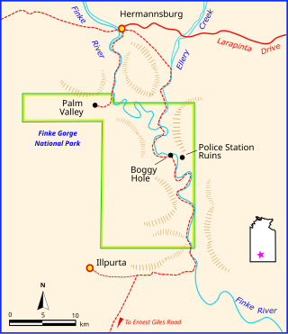
Finke Gorge National Park Protected area in the Northern Territory, Australia

Finke Gorge is a national park in the Northern Territory of Australia, 1318 km south of Darwin. The Park covers an area of 458 km2 (177 sq mi), and includes the impressive desert oasis Palm Valley, home to a diverse range of plant species, many of which are rare and unique to the area. There are good opportunities for bushwalking and bushcamping in the park.

Camooweal Caves National Park Protected area in Queensland, Australia

Camooweal Caves is a national park in Queensland, Australia, 15 km southeast of Camooweal and 1720 km northwest of Brisbane.

Gunbarrel Highway track in Australia

The Gunbarrel Highway is an isolated desert track in the Northern Territory, South Australia and Western Australia. It consists of about 1,350 km (840 mi) of washaways, heavy corrugations, stone, sand and flood plains. The Gunbarrel Highway connects Victory Downs in the Northern Territory to Carnegie Station in Western Australia. Some sources incorrectly show the highway extending west to Wiluna. The road was built as part of Australia's role in the weapons research establishment called Woomera which included Emu Field and Maralinga, both atomic bomb testing sites. The name comes from Len Beadell's Gunbarrel Road Construction Party so named as his intention was to build roads as straight as a gunbarrel.

Oodnadatta Track track in South Australia

The Oodnadatta Track, Australia is an unsealed 617 km (383 mi) outback road between Marree and Marla via Oodnadatta in South Australia. Along the way, the track passes the southern lake of the Kati Thanda-Lake Eyre National Park, and the outback settlements of William Creek and Oodnadatta.

Anne Beadell Highway track in South Australia and Western Australia

The Anne Beadell Highway is an outback unsealed track linking Coober Pedy, South Australia, and Laverton, Western Australia, a total distance of 1,325 km (823 mi). The track was surveyed and built by Len Beadell, Australian surveyor, who named it after his wife. The track passes through remote arid deserts and scrub territory of South Australia and Western Australia, which often have summer temperatures as high as 50 degrees Celsius. Sand dunes predominate for most of the track.

Barkly Highway highway in the Northern Territory and Queensland

The Barkly Highway is a national highway of both Queensland and the Northern Territory.

Victoria Highway highway in the Northern Territory and Western Australia

The Victoria Highway links the Great Northern Highway in Western Australia with the Stuart Highway in the Northern Territory. The highway is a part of the Perth - Darwin National Highway link. It is signed as National Highway 1, and is part of Highway 1, a circular route around the country. It is 555 kilometres (345 mi) long, and most of the route – some 470 kilometres (290 mi) – lies within the Northern Territory. In some areas it runs in parallel with the Northern Territory's Victoria River, from which its name originates.

Tanami Road road in the Northern Territory and Western Australia

The Tanami Road, also known as the Tanami Track and the McGuire Track, runs between the Stuart Highway in the Northern Territory and the Great Northern Highway in Western Australia. Its southern junction is 19 km (12 mi) north of Alice Springs and the northern junction is 17 km (11 mi) south west of Halls Creek. It follows a cattle droving route northwest from the MacDonnell Ranges area of central Australia to Halls Creek in the Kimberley.

Great Central Road track in Western Australia and the Northern Territory

The Great Central Road is a mostly unsealed Australian outback highway that runs 1126 km from Laverton, Western Australia to Yulara, Northern Territory. It passes through a number of small communities on the way.

Georgina River river in Australia

The Georgina River is the north-westernmost of the three major rivers of the Channel Country in Central West Queensland, that also flows through a portion of the Northern Territory, in central Australia. Part of the Lake Eyre basin, the Georgina flows in extremely wet years into Lake Eyre.

Duncan Road road in Western Australia and the Northern Territory

Duncan Road is a generally northeast-southwest former highway in the northeast of Western Australia and northwest of Northern Territory which links the Victoria Highway with Halls Creek. The road, approximately 443 kilometres (275 mi) in length, was designated as National Route 80 from its terminus at Halls Creek through to Nicholson. National Route 80 continued east into the Northern Territory along Buntine Highway, while Duncan Road snakes its way north, crossing the Western Australia / Northern Territory borders numerous times between Buntine Highway and Victoria Highway.

Donohue Highway track in Queensland and the Northern Territory

The Donohue Highway is a 249 km (155 mi) mostly unpaved outback track that leads through the northern foothills of the Simpson Desert in Queensland to Tobermorey Homestead, Northern Territory near the Northern Territory/Queensland border in Australia.

Larapinta Drive road in the Northern Territory

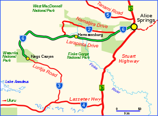
Larapinta Drive is a designated state route in the Northern Territory of Australia. It forms the primary road access to the community of Hermannsburg, as well as a number of tourist attractions located west of Alice Springs, including the Alice Springs Desert Park, West MacDonnell National Park, Kings Canyon, monuments dedicated to Aboriginal artist Albert Namatjira and Royal Flying Doctor Service founder John Flynn, as well as Albert Namatjira's house near Hermannsburg. Larapinta is the local Arrernte name for the Finke River a major watercourse in the area. The length of Larapinta Drive is marketed as part of the "Red Centre Way" tourist drive.

Gary Junction Road track in the Northern Territory and Western Australia

The Gary Junction Road is an outback unsealed road in Australia built by Len Beadell in the 1960s as part of a network of roads for the Weapons Research Establishment at Woomera, South Australia. In its original form, the Gary Junction Road ran from Liebig bore in the Northern Territory to Callawa Station in Western Australia. On present day maps, it is depicted as running from the Tanami Road to Gary Junction, just east of the Canning Stock Route, a distance of 852 kilometres. The road was named after Beadell's only son Gary.

Mount Davies Road track in South Australia

The Mount Davies Road is a remote unsealed outback track which runs from Mount Davies (Pipalyatjara) in the far north-west corner of South Australia to Anne's Corner on the Anne Beadell Highway 397 kilometres to the south-east. It was built during 1956 and 1957 by the Gunbarrel Road Construction Party (GRCP) surveyed and led by Len Beadell for the Weapons Research Establishment at Woomera, South Australia.

Colson Track track in Northern Territory, Australia

The Colson Track is a remote dirt track in Australia running between the Simpson Desert in South Australia and Numery Station in the Northern Territory. It is named in honour of Ted Colson, the first person of European descent to make a successful crossing of the Simpson Desert on foot.

References

  1. Hema, Maps (2005). Australia’s Great Desert Tracks NE Sheet (Map). Eight Mile Plains Queensland: Hema Maps. ISBN   978-1-86500-160-9.
  2. Weir, Stewart owner of Sandover Pastoral Company, 26 February 2015