Sandover River

Last updated

Sandover
Australia Northern Territory relief location map.png
Red pog.svg
Location of the Sandover River mouth in the Northern Territory
Etymology William Sandover [1]
Location
Country Australia
Territory Northern Territory
Region Central Australia [ according to whom? ]
Physical characteristics
Source Macdonnell Ranges
  coordinates 22°37′S135°2′E / 22.617°S 135.033°E / -22.617; 135.033
  elevation534 m (1,752 ft)
Mouth confluence with the Georgina River in wetter seasons
  location
near Urandangi
  coordinates
21°25′S137°18′E / 21.417°S 137.300°E / -21.417; 137.300 Coordinates: 21°25′S137°18′E / 21.417°S 137.300°E / -21.417; 137.300
  elevation
285 m (935 ft)
Length375 km (233 mi)
Basin features
River system Lake Eyre basin
Tributaries 
  leftMueller Creek, Athinna Creek, Arganara Creek, Bullock Creek, Centre Creek
  rightWaite Creek, Bundey River
[2] [3] [4] [5] [6]

The Sandover River is an ephemeral river in the Northern Territory of Australia located in northeast Central Australia. It is the only major tributary of the Georgina River that does not rise in western Queensland. Instead it flows from the eastern Macdonnell Ranges, northward to enter the Georgina near Urandangi. The highest point in the catchment is Bald Hill at 996 metres (3,268 ft), but it enters the Georgina at altitudes below 200 metres (660 ft).

Contents

Course and features

The ephemeral Sandover River is usually dry except when the northern monsoon moves unusually far south into the continent. The average annual rainfall in the catchment area is typically around 275 millimetres (10.8 in) but varies greatly: in dry years like 1928 the total may be as low as 50 millimetres (2.0 in), but in very wet years like 1974, 2000, 2001 and 2010, it can be as high as 760 millimetres (30 in). Most of this rain falls in the summer: between December and March monthly totals have on several occasions exceeded the mean annual rainfall. Flows in the Sandover often fail to reach the Georgina, instead drying out in waterholes well west of Urandangie. However, in very wet periods, such as 1920–1921, 1973-1977 and 1999–2001, water from the Sandover may not only reach the Georgina, but actually flow (via a circuitous route) into Lake Eyre in South Australia.

The river is reported as passing through the localities of Costello and Sandover. Both the Sandover Highway and the Sandover Stock Route are named after the river because their respective alignment follow that of the river. [1]

History

The river was named in 1878 after  William Sandover, the then President of the Legislative Council of South Australia, reportedly by the explorer and botanist. Charles Winnecke. [1]

See also

Related Research Articles

Adelaide River river

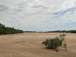
The Adelaide River is a river in the Northern Territory of Australia.

Burdekin River river in Australia

The Burdekin River is a river located in North and Far North Queensland, Australia. The river rises on the northern slopes of Boulder Mountain at Valley of Lagoons, part of the western slope of the Seaview Range, and flows into the Coral Sea at Upstart Bay over 200 kilometres (124 mi) to the southeast of the source, with a catchment area of approximately 130,000 square kilometres (50,000 sq mi). The Burdekin River is Australia's largest river by (peak) discharge volume.

Diamantina River river in Australia

The Diamantina River is a major river located in Central West Queensland and the far north of South Australia.

Cooper Creek river

The Cooper Creek is one of the most famous rivers in Australia because it was the site of the death of the explorers Burke and Wills in 1861. It is sometimes known as the Barcoo River from one of its tributaries and is one of three major Queensland river systems that flow into the Lake Eyre basin. The flow of the creek depends on monsoonal rains falling months earlier and many hundreds of kilometres away in eastern Queensland. At 1,300 kilometres (810 mi) in length it is the second longest inland river system in Australia after the Murray-Darling system.

Avoca River river in Victoria, Australia

The Avoca River, an inland intermittent river of the north–central catchment, part of the Murray-Darling basin, is located in the lower Riverina bioregion and Central Highlands and Wimmera regions of the Australian state of Victoria. The headwaters of the Avoca River rise on the northern slopes of the Pyrenees Range and descend to flow into the ephemeral Kerang Lakes.

Warrego River river in Australia

The Warrego River, an intermittent river that is part of the Darling catchment within the Murray–Darling basin, is located in the south west of Queensland and in the Orana region of New South Wales, Australia. The Warrego River is northernmost tributary of the Darling River.

Georgina River river in Australia

The Georgina River is the north-westernmost of the three major rivers of the Channel Country in Central West Queensland, that also flows through a portion of the Northern Territory, in central Australia. Part of the Lake Eyre basin, the Georgina flows in extremely wet years into Lake Eyre.

South Para River river in South Australia, Australia

The South Para River is a river located in the Mount Lofty Ranges northeast of Adelaide in the Australian state of South Australia.

Gilbert River (Queensland) river in Australia

The Gilbert River is a river located in Far North Queensland, Australia. When combined with the Einasleigh River, the river system is the largest river system in northern Australia.

Normanby River river in northern Queensland, Australia

The Normanby River, comprising the East Normanby River, the West Normanby River, the East Normanby River North Branch, the East Normanby River South Branch and the Granite Normanby River, is a river system located in Far North Queensland, Australia.

Jim Jim Falls Waterfall in Northern Territory, Australia

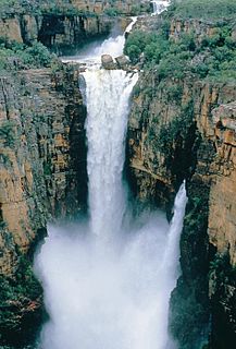
The Jim Jim Falls is a plunge waterfall on the Jim Jim Creek that descends over the Arnhem Land escarpment within the UNESCO World Heritage–listed Kakadu National Park in the Northern Territory of Australia. The Jim Jim Falls area is registered on the Australian National Heritage List.

Mary River (Northern Territory) river in the Northern Territory, Australia

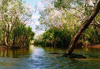
The Mary River flows in the Northern Territory of Australia and is a site of the Mary River National Park.

Annan River river in Queensland, Australia

The Annan River is a river located in the Wet Tropics of Far North Queensland, Australia.

Arnold River (Northern Territory) river in Australia

The Arnold River is a river in the north of the Northern Territory of Australia.

Blackmore River river in Australia

Blackmore River flows into Darwin Harbour close to Darwin in the Northern Territory of Australia.

Elizabeth River (Northern Territory) river in Australia

Elizabeth River flows into Darwin Harbour close to Darwin in the Northern Territory of Australia.

The Wooramel River is an ephemeral river in the Gascoyne region of Western Australia.

Wickham River Australian river

The Wickham River is an ephemeral river, located in the Victoria Bonaparte bioregion of the Northern Territory in Australia.

Goyder River River in Australia

The Goyder River is a river in the Northern Territory, Australia.

Settlement Creek river in Australia

The Settlement Creek is a creek located in the Northern Territory and the state of Queensland, Australia.

References

  1. 1 2 3 "Place Names Register Extract for "Sandover River"". NT Place Names Register. Northern Territory Government. Archived from the original on 26 April 2019. Retrieved 26 April 2019.
  2. "Map of Sandover River, NT". Bonzle Digital Atlas of Australia. Retrieved 21 March 2017.
  3. "Map of Sandover River, NT (1)". Bonzle Digital Atlas of Australia. Retrieved 21 March 2017.
  4. "Map of Sandover River, NT (2)". Bonzle Digital Atlas of Australia. Retrieved 21 March 2017.
  5. "Map of Sandover River, NT (3)". Bonzle Digital Atlas of Australia. Retrieved 21 March 2017.
  6. "Map of Sandover River, NT (4)". Bonzle Digital Atlas of Australia. Retrieved 21 March 2017.