
Roebuck Bay is a bay on the coast of the Kimberley region of Western Australia. Its entrance is bounded in the north by the town of Broome, and in the south by Bush Point and Sandy Point. It is named after HMS Roebuck, the ship captained by William Dampier when he explored the coast of north-western Australia in 1699. The Broome Bird Observatory lies on the northern coast of the bay.

The Swan Bay is a shallow, 30-square-kilometre (12 sq mi) marine embayment at the eastern end of the Bellarine Peninsula in Port Phillip, Victoria, Australia. The township of Queenscliff lies at its southern end, and St Leonards at its northern. It is partly separated from Port Phillip by Swan Island, Duck Island and Edwards Point. Most of the area is included in the Port Phillip Heads Marine National Park as well as being listed as a wetland of international importance under the Ramsar Convention as part of the Port Phillip Bay and Bellarine Peninsula Ramsar Site. The bay is part of the Swan Bay and Port Phillip Bay Islands Important Bird Area, identified as such by BirdLife International because of its importance for orange-bellied parrots, waders and seabirds.

Edwards Point is a 4 km long sand spit extending southwards between Swan Bay and Port Phillip Bay, at the eastern end of the Bellarine Peninsula, Victoria, Australia. It is about 115 km by road south-west of Melbourne and 40 km east of Geelong.

The Corner Inlet is a 600-square-kilometre (230 sq mi) bay located 200 kilometres (120 mi) south-east of Melbourne in the South Gippsland region of Victoria, Australia. Of Victoria's large bays it is both the easternmost and the warmest. It contains intertidal mudflats, mangroves, salt marsh and seagrass meadows, sheltered from the surf of Bass Strait by a complex of 40 sandy barrier islands, the largest of which are Snake, Sunday and Saint Margaret Islands.
The Port Phillip Bay and Bellarine Peninsula Ramsar Site is one of the Australian sites listed under the Ramsar Convention as a wetland of international importance. It was designated on 15 December 1982, and is listed as Ramsar Site No.266. Much of the site is also part of either the Swan Bay and Port Phillip Bay Islands Important Bird Area or the Werribee and Avalon Important Bird Area, identified as such by BirdLife International because of their importance for wetland and waterbirds as well as for orange-bellied parrots. It comprises some six disjunct, largely coastal, areas of land, totalling 229 km2, along the western shore of Port Phillip and on the Bellarine Peninsula, in the state of Victoria. Wetland types protected include shallow marine waters, estuaries, freshwater lakes, seasonal swamps, intertidal mudflats and seagrass beds.
Blue Mud Bay is a large, shallow, partly enclosed bay on the eastern coast of Arnhem Land, in the Northern Territory of Australia, facing Groote Eylandt on the western side of the Gulf of Carpentaria. It lies 580 km (360 mi) east-south-east of Darwin in the Arnhem Coast bioregion. Its name was given to a landmark court ruling affirming that the Aboriginal traditional owners of much of the Northern Territory's coastline have exclusive rights over commercial and recreational fishing in tidal waters overlying their land.
Buckingham Bay is a large, rectangular bay on the northern coast of Arnhem Land, in the Northern Territory of Australia. It lies 520 km east of Darwin and 120 km west of Nhulunbuy.

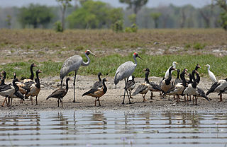
The Gulf Plains Important Bird Area comprises 8868 km2 of the low-lying coastal plains bordering the south-eastern corner of the Gulf of Carpentaria in north-west Queensland, Australia. It was identified by BirdLife International as an Important Bird Area (IBA) because of its importance to global populations of waders and other birds.
The Legune Important Bird Area comprises a low-lying, swampy, floodplain peninsula at the south-eastern end of the Joseph Bonaparte Gulf in the Top End of the Northern Territory of Australia. The land is part of the Legune Station, a cattle station and pastoral lease.

Limmen Bight is a bight, or large, open bay, located in the Northern Territory of Australia at the western end of the Gulf of Carpentaria about 360 kilometres (220 mi) east of the town of Katherine. It is part of the traditional lands and waters of the Marra people. It was named in April 1644 by Abel Tasman for one of his ships on his voyage of exploration along the northern Australian coast. It contains the second largest area of tidal flats in the Northern Territory.
The Milingimbi Islands Important Bird Area comprises 94 km2 of land in the Milingimbi, or Crocodile Islands group, of the Northern Territory of Australia. The area is traditionally owned Aboriginal land. The mudflats are an important staging site for migratory waders, or shorebirds.

The Port McArthur Tidal Wetlands System comprises a 994 km2 tract of tidal wetlands on the south-west coast of the Gulf of Carpentaria in the Northern Territory of Australia. The land extends along the coast opposite the Sir Edward Pellew Group of Islands, incorporating the estuaries of the McArthur and Wearyan Rivers. It is an important site for waders, or shorebirds.

The Repulse Bay to Ince Bay Important Bird Area is a disjunct stretch of coastline comprising a series of relatively sheltered beaches in the Mackay-Whitsunday region of Central Queensland, north-eastern Australia. With an area of 134 km2, it extends for about 180 km from Repulse Bay in the north through the city of Mackay to Ince Bay and Cape Palmerston in the south. It is an important site for waders, or shorebirds.
Shoal Bay is a shallow bay lying adjacent to, and north of, the city of Darwin in the Northern Territory of Australia. Encompassing Hope Inlet at its eastern end, it is characterised by extensive areas of intertidal mudflats and mangroves and is an important site for waders, or shorebirds. The bay is situated within the Shoal Bay Coastal Reserve, a protected area that was established in 2000.
The Spencer Gulf Important Bird Area comprises a 460.38 square kilometres strip of coastal land extending for about 100 kilometres along the north-eastern coast of the Spencer Gulf in South Australia. It is considered to be an important site for waders, or shorebirds.

Tourville and Murat Bays Important Bird Area is an important bird area in South Australia with a combined area of 117 square kilometres, located west to the town of Ceduna on the north-west corner of the Eyre Peninsula in the Great Australian Bight. It is considered to be an important area because of the resident populations of waders, or shorebirds.

The Werribee and Avalon Important Bird Area comprises some 37 km2 of coastal land along the northwestern shore of Port Phillip in the state of Victoria, in southeastern Australia. It is important for a wide variety of waterbirds.
The Anson Bay, Daly and Reynolds River Floodplains comprise some 2,656 square kilometres (1,025 sq mi) of seasonally inundated floodplains around Anson Bay, and the lower reaches of the Daly, Reynolds and Docherty Rivers entering the bay, on the west coast of the Top End of the Northern Territory of Australia. Anson's Bay lies about 120 kilometres (75 mi) south-west of Darwin, on the eastern side of the Joseph Bonaparte Gulf, opening on to the Timor Sea. The site is important for large numbers, and a wide variety, of waterbirds.

The Cadell and Blyth Floodplains consist of the 432 square kilometres (167 sq mi) floodplain of the lower reaches of the Blyth and Cadell Rivers of northern Arnhem Land in the Top End of the Northern Territory of Australia. It is an important site for waterbirds.
The Hyland Bay and Moyle Floodplain comprises the floodplain of the lower reaches of the Moyle and Little Moyle Rivers, and the adjoining mudflats of Hyland Bay, on the west coast of the Top End of the Northern Territory of Australia. The site lies about 200 kilometres (124 mi) south-west of Darwin and 30 km (19 mi) north-east of the Aboriginal community of Wadeye. It is an important site for waterbirds.

