Blackmore | |
River | |
Country | Australia |
---|---|
Territory | Northern Territory |
Source | |
- location | Wild Horse Plain, Australia |
- elevation | 21 m (69 ft) |
Mouth | |
- location | Darwin Harbour, Australia |
- elevation | 0 m (0 ft) |
- coordinates | 12°38′27″S130°57′03″E / 12.64083°S 130.95083°E Coordinates: 12°38′27″S130°57′03″E / 12.64083°S 130.95083°E |
Length | 25 km (16 mi) |
Basin | 848 km2 (327 sq mi) |
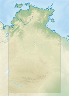
Location of the Blackmore River mouth in the Northern Territory | |
[1] | |
Blackmore River flows into Darwin Harbour close to Darwin in the Australian Northern Territory. [2]
Darwin Harbour is the body of water close to Darwin in the Northern Territory of Australia. It opens to the north at a line from Charles Point in the west to Lee Point in the east into the Beagle Gulf and connects via the Clarence Strait with the Van Diemen Gulf. It contains Port Darwin, which is flanked by Frances Bay to the east and Cullen Bay to the west.
Darwin is the capital city of the Northern Territory of Australia, situated on the Timor Sea. It is the largest city in the sparsely populated Northern Territory, with a population of 145,916. It is the smallest and most northerly of the Australian capital cities, and acts as the Top End's regional centre.
Australia, officially the Commonwealth of Australia, is a sovereign country comprising the mainland of the Australian continent, the island of Tasmania and numerous smaller islands. It is the largest country in Oceania and the world's sixth-largest country by total area. The neighbouring countries are Papua New Guinea, Indonesia and East Timor to the north; the Solomon Islands and Vanuatu to the north-east; and New Zealand to the south-east. The population of 25 million is highly urbanised and heavily concentrated on the eastern seaboard. Australia's capital is Canberra, and its largest city is Sydney. The country's other major metropolitan areas are Melbourne, Brisbane, Perth and Adelaide.
The headwaters of the river rise at an elevation of 21 metres (69 ft) on the Wild Horse Plain and flow northwards past Tumbling Waters and through the Blackmore River Conservation Reserve. The river eventually discharges into Port Darwin and then the Timor Sea.
The Timor Sea is a relatively shallow sea bounded to the north by the island of Timor, to the east by the Arafura Sea, to the south by Australia.
The Elizabeth River and Blackmore River catchments together occupy an area of 1,150 square kilometres (444 sq mi), [3] with the Blackmore catchment occupying 848 square kilometres (327 sq mi).
Elizabeth River flows into Darwin Harbour close to Darwin in the Australian Northern Territory.
The estuary formed at the river mouth is tidal in nature and in near pristine condition. [4]
An estuary is a partially enclosed coastal body of brackish water with one or more rivers or streams flowing into it, and with a free connection to the open sea.
The climate of the Blackmore River region is monsoon tropical with two distinct seasons: the Dry and the Wet. The Dry lasts for 6 months between April and September with an average rainfall of 24 mm, whereas the Wet lasts between October and March with an average monthly rainfall of 254 mm/month (according to the Bureau of Meteorology, 1999). The majority of the rain falls between December and April. Runoff varies between 250–1000 mm.
Peak flow for the Blackmore River occurs in February with 605Ml/day, after which it slowly decreases until July when there is no freshwater input into Darwin Harbour until the onset of the following wet season (Padovan 1997). Cyclone frequency is low to moderate. [2]
In meteorology, a cyclone is a large scale air mass that rotates around a strong center of low atmospheric pressure. Cyclones are characterized by inward spiraling winds that rotate about a zone of low pressure. The largest low-pressure systems are polar vortices and extratropical cyclones of the largest scale. Warm-core cyclones such as tropical cyclones and subtropical cyclones also lie within the synoptic scale. Mesocyclones, tornadoes and dust devils lie within smaller mesoscale. Upper level cyclones can exist without the presence of a surface low, and can pinch off from the base of the tropical upper tropospheric trough during the summer months in the Northern Hemisphere. Cyclones have also been seen on extraterrestrial planets, such as Mars and Neptune. Cyclogenesis is the process of cyclone formation and intensification. Extratropical cyclones begin as waves in large regions of enhanced mid-latitude temperature contrasts called baroclinic zones. These zones contract and form weather fronts as the cyclonic circulation closes and intensifies. Later in their life cycle, extratropical cyclones occlude as cold air masses undercut the warmer air and become cold core systems. A cyclone's track is guided over the course of its 2 to 6 day life cycle by the steering flow of the subtropical jet stream.
The water quality at the upper estuary and freshwater monitoring sites of the Department of Land Resource Management of the Northern Territory Government was 2011 in moderate condition. [5]
The underlying lithology is dominated by Permian siltstones and sandstones. [2]
Alligator Rivers is the name of an area in an Arnhem Land region of the Northern Territory of Australia, containing three rivers, the East, West, and South Alligator Rivers. It is regarded as one of the richest biological regions in Australia, with part of the region in the Kakadu National Park. It is an Important Bird Area (IBA), lying to the east of the Adelaide and Mary River Floodplains IBA. It also contains mineral deposits, especially uranium, and the Ranger Uranium Mine is located there. The area is also rich in Australian Aboriginal art, with 1500 sites. The Kakadu National Park is one of the few World Heritage sites on the list because of both its natural and human heritage values. They were explored by Lieutenant Phillip Parker King in 1820, who named them in the mistaken belief that the crocodiles in the estuaries were alligators.
The Georgina River is the north-westernmost of the three major rivers of the Channel Country in Central West Queensland, that also flows through a portion of the Northern Territory, in central Australia. Part of the Lake Eyre basin, the Georgina flows in extremely wet years into Lake Eyre.
The Mary River flows in the Northern Territory of Australia and is a site of the Mary River National Park.
The Fitzmaurice River is a river in Australia's Northern Territory.
The Calvert River is a river in the Northern Territory of Australia.
The Wildman River is a river in the Darwin Coastal bioregion of the Northern Territory, Australia.
Buckingham River is a river in the Northern Territory of Australia.
Liverpool River is a river in the Northern Territory of Australia.
The Keep River is a river, located in the Victoria Bonaparte bioregion of Western Australia and the Northern Territory in Australia.
The Blyth River is a river in the Northern Territory, Australia.
The Koolatong River is a river in the Northern Territory, Australia.
The Moyle River is a river in the Northern Territory, Australia.
The Goomadeer River is a river in the Northern Territory, Australia.
The Towns River is a river in the Northern Territory, Australia.
The Limmen Bight River is a river in the Northern Territory, Australia.
The Rosie River also known as Rosie Creek is a river in the Northern Territory, Australia.
The Robinson River is a river in Australia's Northern Territory.
The Settlement Creek is a creek located in the Northern Territory and the state of Queensland, Australia.