
The Adelaide River is a river in the Northern Territory of Australia.

Darwin Harbour is a body of water close to the city of Darwin in the Northern Territory of Australia. It is the traditional waterways of the Larrakia people.

Peel River, a watercourse that is part of the Namoi catchment within the Murray–Darling basin, is located in the North West Slopes and Plains district of New South Wales, Australia.
Daly is an electoral division of the Legislative Assembly in Australia's Northern Territory. It was created in 2001, and takes its name from the Daly River region which lies at the heart of the electorate. Daly covers some 77,395 km², encompassing the towns of Adelaide River, Acacia Hills, Batchelor, Dundee Beach, Nauiyu Nambiyu, Pine Creek, Timber Creek and Wadeye. There were 5,622 people enrolled in the electorate as of August 2020.
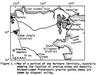
Alligator Rivers is the name of an area in an Arnhem Land region of the Northern Territory of Australia, containing three rivers, the East, West, and South Alligator Rivers. It is regarded as one of the richest biological regions in Australia, with part of the region in the Kakadu National Park. It is an Important Bird Area (IBA), lying to the east of the Adelaide and Mary River Floodplains IBA. It also contains mineral deposits, especially uranium, and the Ranger Uranium Mine is located there. The area is also rich in Australian Aboriginal art, with 1500 sites. The Kakadu National Park is one of the few World Heritage sites on the list because of both its natural and human heritage values. They were explored by Lieutenant Phillip Parker King in 1820, who named them in the mistaken belief that the crocodiles in the estuaries were alligators.

The Victoria River is a river in the bioregion of Victoria Bonaparte in the Northern Territory of Australia. It flows for 560 kilometres (350 mi) from its source south of the Judbarra / Gregory National Park to the Joseph Bonaparte Gulf in the Timor Sea.
The King River is a river in the Northern Territory of Australia. It is a tributary of the Daly River which ultimately flows into the Timor Sea.

The Roper River is a large perennial river located in the Katherine region of the Northern Territory of Australia.

Ginninderra Creek, a partly perennial stream of the Murrumbidgee catchment within the Murray–Darling basin, is located in the Capital Country region spanning both the Australian Capital Territory and New South Wales, Australia.

The Mary River flows in the Northern Territory of Australia and is a site of the Mary River National Park.
The Anson Bay, Daly and Reynolds River Floodplains comprise some 2,656 square kilometres (1,025 sq mi) of seasonally inundated floodplains around Anson Bay, and the lower reaches of the Daly, Reynolds and Docherty Rivers entering the bay, on the west coast of the Top End of the Northern Territory of Australia. Anson's Bay lies about 120 kilometres (75 mi) south-west of Darwin, on the eastern side of the Joseph Bonaparte Gulf, opening on to the Timor Sea. The site is important for large numbers, and a wide variety, of waterbirds.

The Daly River is a river in the Northern Territory of Australia. It is part of the Daly Catchment.
Litchfield Station is a pastoral lease that operates as a cattle station. It is located about 44 kilometres (27 mi) north west of Daly River and 69 kilometres (43 mi) west of Adelaide River in the Northern Territory of Australia. Composed primarily of open grazing land, the property occupies an area of 1,336 square kilometres (516 sq mi). The two adjoining sister properties are Elizabeth Downs and Tipperary Stations; all three currently operate as a single entity, often referred to as the Tipperary Group.
Liverpool River is a river in the Northern Territory of Australia. It is the largest of the tidal river systems of northern Arnhem Land, which includes two major tributaries, the Tomkinson and Mann Rivers.
The Moyle River is a river in the Northern Territory, Australia.
The Goomadeer River is a river in the Northern Territory, Australia.

The Towns River is a river in the Northern Territory, Australia.
The Settlement Creek is a creek in the Northern Territory and the state of Queensland, Australia.
The Watson River is a river in Far North Queensland, Australia.
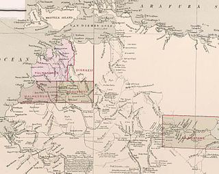
County of Malmesbury was one of the five counties in the Northern Territory which are part of the Lands administrative divisions of Australia.
