Elizabeth River (Northern Territory)

Last updated

Elizabeth
Aerial photo of Elizabeth River Bridge, 17 km south of Darwin, Northern Territory, Australia.jpg
The Elizabeth River Bridge across Elizabeth River, upstream the East Arm of Darwin Harbour
Australia Northern Territory relief location map.png
Red pog.svg
Location of the Elizabeth River mouth in the Northern Territory
Location
Country Australia
Territory Northern Territory
Physical characteristics
Source 
  location Noonamah, Northern Territory, Australia
  elevation35 m (115 ft)
Mouth  
  location
East Arm, Australia
  coordinates
12°32′31″S130°58′55″E / 12.54194°S 130.98194°E / -12.54194; 130.98194
  elevation
0 m (0 ft)
Length28 km (17 mi)
[1]

Elizabeth River flows into Darwin Harbour close to Darwin in the Northern Territory of Australia. [2]

Contents

Course

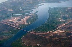
The headwaters of the river rise south of Noonamah and flow in a north westerly direction and cross the Stuart Highway south of Humpty Doo. It continues through an estuarine area and discharges into the East Arm of Darwin Harbour then Beagle Gulf and eventually into the Timor Sea.

The river shares a catchment area with the Finniss and Howard Rivers, the combined watershed occupies an area of 8,672 square kilometres (3,348 sq mi). [3]

Climate

The climate of the Elizabeth River region is monsoon tropical with two distinct seasons: dry and wet. The dry season lasts for six months between April and September with an average rainfall of 24 mm, whereas the wet season lasts between October and March with an average monthly rainfall of 254 mm/month (according to the Bureau of Meteorology, 1999). The majority of the rain falls between December and April. Runoff varies between 250–1000 mm.

Peak flow for the Elizabeth River occurs in February with 389Ml/day, after which it slowly decreases until July when there is no freshwater input into Darwin Harbour until the onset of the following wet season (Padovan 1997). Cyclone frequency is low to moderate. [2]

The Finniss, Elizabeth and Howard Rivers have a mean annual outflow of 3,000 gigalitres (3.924×10⁹ cu yd), [4]

Water quality

The water quality at the upper estuary monitoring sites of the Northern Territory Government was 2011 in excellent condition. Water quality at the freshwater monitoring sites was in very good condition in 2011. [5]

Geology

The underlying lithology is dominated by Permian siltstones and sandstones. [2]

See also

Related Research Articles

<span class="mw-page-title-main">Darwin, Northern Territory</span> Capital city of the Northern Territory, Australia

Darwin is the capital city of the Northern Territory, Australia. With a population of 139,902 at the 2021 census, the city contains most of the sparsely populated Northern Territory's residents. It is the smallest, wettest, and most northerly of the Australian capital cities and serves as the Top End's regional centre.

<span class="mw-page-title-main">Adelaide River</span> River in Northern Territory, Australia

The Adelaide River is a river in the Northern Territory of Australia.

<span class="mw-page-title-main">Darwin Harbour</span> Harbour in Northern Territory, Australia

Darwin Harbour is a body of water close to Darwin in the Northern Territory of Australia. It opens to the north at a line from Charles Point in the west to Lee Point in the east into the Beagle Gulf and connects via the Clarence Strait with the Van Diemen Gulf. It contains Port Darwin, which is flanked by Frances Bay to the east and Cullen Bay to the west.

<span class="mw-page-title-main">Top End</span> Region in the Northern Territory, Australia

The Top End of Australia's Northern Territory is a geographical region encompassing the northernmost section of the Northern Territory, which aside from the Cape York Peninsula is the northernmost part of the Australian continent. It covers a rather vaguely defined area of about 245,000 km² behind the northern coast from the Northern Territory capital of Darwin across to Arnhem Land with the Indian Ocean on the west, the Arafura Sea to the north, and the Gulf of Carpentaria to the east, and with the almost waterless semi-arid interior of Australia to the south, beyond the huge Kakadu National Park.

<span class="mw-page-title-main">Southwest Australia</span> Biogeographic region of Western Australia

Southwest Australia is a biogeographic region in Western Australia. It includes the Mediterranean-climate area of southwestern Australia, which is home to a diverse and distinctive flora and fauna.

<span class="mw-page-title-main">Alligator Rivers</span> River delta in northern Australia

Alligator Rivers is the name of an area in an Arnhem Land region of the Northern Territory of Australia, containing three rivers, the East, West, and South Alligator Rivers. It is regarded as one of the richest biological regions in Australia, with part of the region in the Kakadu National Park. It is an Important Bird Area (IBA), lying to the east of the Adelaide and Mary River Floodplains IBA. It also contains mineral deposits, especially uranium, and the Ranger Uranium Mine is located there. The area is also rich in Australian Aboriginal art, with 1500 sites. The Kakadu National Park is one of the few World Heritage sites on the list because of both its natural and human heritage values. They were explored by Lieutenant Phillip Parker King in 1820, who named them in the mistaken belief that the crocodiles in the estuaries were alligators.

<span class="mw-page-title-main">Tropical savanna climate</span> Climate subtype

Tropical savanna climate or tropical wet and dry climate is a tropical climate sub-type that corresponds to the Köppen climate classification categories Aw and As. The driest month has less than 60 mm (2.4 in) of precipitation and also less than mm of precipitation.

<span class="mw-page-title-main">Mary River (Northern Territory)</span> River in Northern Territory, Australia

The Mary River flows in the Northern Territory of Australia and is a site of the Mary River National Park.

<span class="mw-page-title-main">Gulf Country</span> Queensland region

The Gulf Country or North West Queensland is the region of woodland and savanna grassland surrounding the Gulf of Carpentaria in north western Queensland and eastern Northern Territory on the north coast of Australia. The region is also called the Gulf Savannah. The Gulf Country is crossed by the Savannah Way highway.

The Fitzmaurice River is a river in the Northern Territory of Australia.

Eprapah Creek is a sub-tropical stream in Redland City close to Brisbane in South East Queensland, Australia.

<span class="mw-page-title-main">Carpentaria tropical savanna</span> Ecoregion in Australia

The Carpentaria tropical savanna is a tropical and subtropical grasslands, savannas, and shrublands ecoregion in northern Australia.

<span class="mw-page-title-main">Daly River (Northern Territory)</span> River in Northern Territory, Australia

The Daly River is a river in the Northern Territory of Australia. Settlement on the river is centred on the Aboriginal community of Nauiyu, originally the site of a Catholic mission, as well as the town of Daly River itself, at the river crossing a few kilometres to the south. The Daly River is part of the Daly Catchment that flows from northern Northern Territory to central Northern Territory.

<span class="mw-page-title-main">Escape Cliffs</span> Historic settlement site in the Northern Territory, Australia

Escape Cliffs is a place on the northern coast of the Northern Territory of Australia, on the western coast of the Cape Hotham peninsula, and the eastern shore of Adam Bay, near the mouth and estuary of the Adelaide River. It lies about 60 km north-east of Darwin and is located in the Cape Hotham sector of the Djukbinj National Park. It was named by John Lort Stokes of HMS Beagle after visiting the spot in 1840, and refers to an incident where he and Lieut. Helpman escaped with their lives after being attacked by hostile Aboriginal men.

Blackmore River flows into Darwin Harbour close to Darwin in the Northern Territory of Australia.

The Wildman River is a river in the Darwin Coastal bioregion of the Northern Territory, Australia.

Liverpool River is a river in the Northern Territory of Australia. It is the largest of the tidal river systems of northern Arnhem Land, which includes two major tributaries, the Tomkinson and Mann Rivers.

The Black Jungle Conservation Reserve is a protected area in the Northern Territory of Australia near the territorial capital of Darwin. The rural area of Darwin and its development has a contrasting history to the more southern regions and their rural zones. The development of the rural area around Darwin occurred after 1950 as agricultural ventures were trialed. Prior to this the area was tropical savanna with pockets of monsoon rainforest and melaleuca swamps, unchanged for thousands of years, except by the traditional Aboriginal owners of the land who hunted and gathered and managed the landscape with fire. Black Jungle Conservation Reserve is a part of the Adelaide River Coastal Floodplain system which encompasses Black Jungle and Lambells Lagoon Conservation Reserves, Fogg Dam, Leaning Tree Lagoon Nature Park, Melacca Swamp and Djukbinj National Park. These Reserves encompass a range of wetland types and form part of the internationally significant Adelaide River floodplain.

The Settlement Creek is a creek in the Northern Territory and the state of Queensland, Australia.

<span class="mw-page-title-main">Darwin River Dam</span> Dam in Northern Territory, Australia

The Darwin River Dam is in Australia's Northern Territory on the Darwin River. The water catchment it contains is the major source for the city of Darwin.

References

  1. "Map of Elizabeth River, NT". Bonzle Digital Atlas of Australia. Retrieved 25 May 2015.
  2. 1 2 3 N Smit, R Billyard and L Ferns: Beagle Gulf Benthic Survey: Characterisation of soft substrates. Archived 28 March 2012 at the Wayback Machine Technical Report No. 66 (2000), Parks and Wildlife Commission of the Northern Territory.
  3. "Drainage divisions" (PDF). Commonwealth of Australia. 2001. Archived from the original (PDF) on 1 April 2015. Retrieved 26 May 2015.
  4. "Finniss/Elizabeth/Howard Rivers" (PDF). TRaCK. 2009. Retrieved 12 May 2015.
  5. Elizabeth River and Estuary