Limmen Bight River

Last updated

Limmen Bight
Australia Northern Territory relief location map.png
Red pog.svg
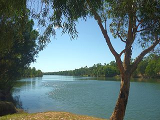
Location of the Limmen Bight River mouth in the Northern Territory
Location
Country Australia
Territory Northern Territory
Physical characteristics
SourceFavenc Range
  location Australia
Mouth Limmen Bight
  location
Gulf of Carpentaria, Australia
  coordinates
15°11′41″S135°37′9″E / 15.19472°S 135.61917°E / -15.19472; 135.61917 Coordinates: 15°11′41″S135°37′9″E / 15.19472°S 135.61917°E / -15.19472; 135.61917
Basin size15,938 km2 (6,154 sq mi)
Discharge 
  average36.8 m3/s (1,300 cu ft/s)
[1]

The Limmen Bight River is a river in the Northern Territory, Australia.

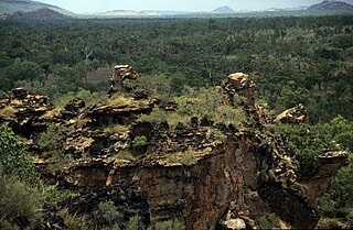
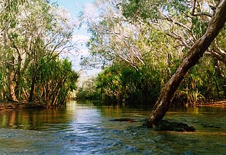
The headwaters rise at the base of the Favenc Range near O.T. Downs [2] and Broadmere Stations. It then flows in a northerly direction, with many smaller tributaries feeding the river which forms a series of braided channels across the plains. It flows past Sculthorpe Pound and through Limmen Gate hemmed to the east by the Tawallah Range. It continues through Limmen National Park past the Four Archers near Burketown Crossing and eventually discharges in the Limmen Bight in the Gulf of Carpentaria. Fifteen tributaries join the river including October Creek, Balbirni Creek, Lansen Creek, Crooked Creek, Tyangkulta Creek, Cox River and Nathan River. It also flows through a large permanent billabong, Broadmere waterhole.

The catchment occupies an area of 15,938 square kilometres (6,154 sq mi) and is situated between the Roper River and Towns River catchments to the north and west, the McArthur River catchment to the south and the Rosie River catchment to the east. [3] The river has a mean annual outflow of 1,160 gigalitres (1.517×10⁹ cu yd), [4]

The river's estuary, which occupies an area of 62.1 square kilometres (24 sq mi) of open water, is in near pristine condition. [5] The tide-dominated delta has multiple channels and is surrounded by an area of 21.2 square kilometres (8 sq mi) covered with mangroves. [6]

The river was named after the Limmen Bight which it discharges into. The bight was named by the explorer Abel Tasman in 1644 after his ship, the Limmen. [7]

See also

Related Research Articles

Roper River River in Northern Territory, Australia

The Roper River is a large perennial river located in the Katherine region of the Northern Territory of Australia.

McArthur River

The McArthur River is a river in the Northern Territory of Australia which flows into the Gulf of Carpentaria at Port McArthur, opposite the Sir Edward Pellew Group of Islands. The river was named by Ludwig Leichhardt while he explored the area in 1845. He named the River after James MacArthur and the MacArthur family of Camden, who were enthusiastic supporters of his expedition. The McArthur River has significance for the local Aboriginal communities, who use it for fishing and other traditional activities.

Mary River (Northern Territory)

The Mary River flows in the Northern Territory of Australia and is a site of the Mary River National Park.

The Calvert River is a river in the Northern Territory of Australia.

Blackmore River flows into Darwin Harbour close to Darwin in the Northern Territory of Australia.

The Wildman River is a river in the Darwin Coastal bioregion of the Northern Territory, Australia.

Liverpool River is a river in the Northern Territory of Australia. It is the largest of the tidal river systems of northern Arnhem Land, which includes two major tributaries, the Tomkinson and Mann Rivers.

The Goromuru River is a river, located in the Northern Territory in Australia.

Keep River River in the Northern Territory and Western Australia

The Keep River is a river located in the Victoria Bonaparte bioregion of Western Australia and the Northern Territory in Australia.

The Blyth River is a river in the Northern Territory, Australia.

The Koolatong River is a river in the Northern Territory, Australia.

The Moyle River is a river in the Northern Territory, Australia.

The Goomadeer River is a river in the Northern Territory, Australia.

Goyder River River in Australia

The Goyder River is a river in the Northern Territory, Australia.

The Walker River is a river in the Northern Territory, Australia.

Towns River

The Towns River is a river in the Northern Territory, Australia.

The Rosie River also known as Rosie Creek is a river in the Northern Territory, Australia.

The Robinson River is a river in Australia's Northern Territory.

The Settlement Creek is a creek located in the Northern Territory and the state of Queensland, Australia.

Gregory River (Australia) River in Queensland, Australia

The Gregory River is a river located in the Northern Territory and the state of Queensland, Australia. The river is the largest perennial river in arid and semi-arid Queensland, one of the few permanently flowing rivers in the northwest of Queensland.

References

  1. "Map of Limmen Bight River, NT". Bonzle Digital Atlas of Australia. Retrieved 13 May 2015.
  2. "Bauhinia Downs - Northern Territory" (PDF). Australian Government Publishing Service. 1964. Retrieved 17 May 2015.
  3. "Drainage Divisions" (PDF). Commonwealth of Australia. 2005. Archived from the original (PDF) on 1 April 2015. Retrieved 13 May 2015.
  4. "Limmen Bight River" (PDF). TRaCK. 2009. Retrieved 14 May 2015.
  5. "Australian Catchment, River and Estuary Assessment" (PDF). Natural Heritage Trust. 2002. Archived from the original (PDF) on 13 February 2014. Retrieved 14 May 2015.
  6. "Limmen River, NT". Australian online Coastal Information. Commonwealth of Australia . Retrieved 24 May 2015.
  7. "Place Names Register Extract - Limmen Bight". NT Place Names Register. Northern Territory Government . Retrieved 14 May 2015.