| Rosie | |
|---|---|
 Location of the Rosie River mouth in the Northern Territory | |
| Location | |
| Country | Australia |
| Territory | Northern Territory |
| Physical characteristics | |
| Source | Tawallah Range |
| ⁃ elevation | 76 m (249 ft) |
| Mouth | Gulf of Carpentaria |
⁃ location | Australia |
⁃ coordinates | 15°26′31″S136°11′14″E / 15.44194°S 136.18722°E Coordinates: 15°26′31″S136°11′14″E / 15.44194°S 136.18722°E |
⁃ elevation | 0 m (0 ft) |
| Basin size | 5,044 km2 (1,947 sq mi) |
| Discharge | |
| ⁃ average | 17.1 m3/s (600 cu ft/s) |
| Basin features | |
| Tributaries | |
| ⁃ right | Little Rosie Creek, Jumpup Creek, Buffalo Creek (Australia), Warramana Creek |
| [1] | |
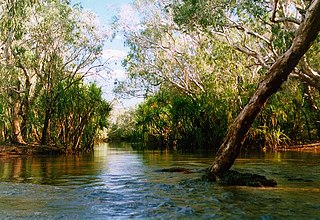
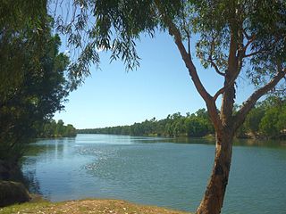
The Rosie River also known as Rosie Creek is a river in the Northern Territory, Australia.

A river is a natural flowing watercourse, usually freshwater, flowing towards an ocean, sea, lake or another river. In some cases a river flows into the ground and becomes dry at the end of its course without reaching another body of water. Small rivers can be referred to using names such as stream, creek, brook, rivulet, and rill. There are no official definitions for the generic term river as applied to geographic features, although in some countries or communities a stream is defined by its size. Many names for small rivers are specific to geographic location; examples are "run" in some parts of the United States, "burn" in Scotland and northeast England, and "beck" in northern England. Sometimes a river is defined as being larger than a creek, but not always: the language is vague.

The Northern Territory is an Australian territory in the central and central northern regions of Australia. It shares borders with Western Australia to the west, South Australia to the south, and Queensland to the east. To the north, the territory looks out to the Timor Sea, the Arafura Sea and the Gulf of Carpentaria, including Western New Guinea and other Indonesian islands. The NT covers 1,349,129 square kilometres (520,902 sq mi), making it the third-largest Australian federal division, and the 11th-largest country subdivision in the world. It is sparsely populated, with a population of only 245,800, fewer than half as many people as Tasmania.

Australia, officially the Commonwealth of Australia, is a sovereign country comprising the mainland of the Australian continent, the island of Tasmania, and numerous smaller islands. It is the largest country in Oceania and the world's sixth-largest country by total area. The neighbouring countries are Papua New Guinea, Indonesia, and East Timor to the north; the Solomon Islands and Vanuatu to the north-east; and New Zealand to the south-east. The population of 26 million is highly urbanised and heavily concentrated on the eastern seaboard. Australia's capital is Canberra, and its largest city is Sydney. The country's other major metropolitan areas are Melbourne, Brisbane, Perth, and Adelaide.
The headwaters at found at the northern end of the Tawallah Range and the river flows in an easterly direction across the uninhabited plain then discharging into the Gulf of Carpentaria.

The Gulf of Carpentaria is a large, shallow sea enclosed on three sides by northern Australia and bounded on the north by the eastern Arafura Sea. The northern boundary is generally defined as a line from Slade Point, Queensland in the northeast, to Cape Arnhem, Northern Territory in the west.
The estuary at the river mouth occupies an area of 7.04 square kilometres (3 sq mi) and is in near pristine condition. It is river dominated in nature with a wave dominated delta and multiple channels and has an area of 25.4 hectares (63 acres) covered with mangroves. [2]

An estuary is a partially enclosed coastal body of brackish water with one or more rivers or streams flowing into it, and with a free connection to the open sea.

A mangrove is a shrub or small tree that grows in coastal saline or brackish water. The term is also used for tropical coastal vegetation consisting of such species. Mangroves occur worldwide in the tropics and subtropics, mainly between latitudes 25° N and 25° S. The total mangrove forest area of the world in 2000 was 137,800 square kilometres (53,200 sq mi), spanning 118 countries and territories.
The catchment occupies an area of 5,044 square kilometres (1,947 sq mi) and is situated between the Limmen Bight River catchment to the north and east and the McArthur River catchment to the south. [3] The river has a mean annual outflow of 540 gigalitres (706,300,000 cu yd). [4]

The Limmen Bight River is a river in the Northern Territory, Australia.
The McArthur River is a river in the Northern Territory of Australia which flows into the Gulf of Carpentaria at Port McArthur, opposite the Sir Edward Pellew Group of Islands. The river was named by Ludwig Leichhardt while he explored the area in 1845. He names the River after James MacArthur and the MacArthur family of Camden who were enthusiastic supporters of his expedition. The McArthur River has significance for the local Aboriginal communities who use it for fishing and other traditional activities.