
The Murrumbidgee River is a major tributary of the Murray River within the Murray–Darling basin and the second longest river in Australia. It flows through the Australian state of New South Wales and the Australian Capital Territory, descending 1,500 metres (4,900 ft) over 1,485 kilometres (923 mi), generally in a west-northwesterly direction from the foot of Peppercorn Hill in the Fiery Range of the Snowy Mountains towards its confluence with the Murray River near Boundary Bend.

The Darling River is the third-longest river in Australia, measuring 1,472 kilometres (915 mi) from its source in northern New South Wales to its confluence with the Murray River at Wentworth, New South Wales. Including its longest contiguous tributaries it is 2,844 km (1,767 mi) long, making it the longest river system in Australia. The Darling River is the outback's most famous waterway.

The Cooper Creek is a river in the Australian states of Queensland and South Australia. It was the site of the death of the explorers Burke and Wills in 1861. It is sometimes known as the Barcoo River from one of its tributaries and is one of three major Queensland river systems that flow into the Lake Eyre basin. The flow of the creek depends on monsoonal rains falling months earlier and many hundreds of kilometres away in eastern Queensland. It is 1,300 kilometres (810 mi) in length.

The Castlereagh River is located in the central–western district of New South Wales, Australia. It is part of the Macquarie-Castlereagh catchment within the Murray–Darling basin and is an unregulated river, meaning no dams or storage have been built on it to control flows. On a map of NSW, the Castlereagh has a distinctive appearance among the north-western rivers for its fish-hook-like shape: from upstream in the north at its confluence with the Macquarie River it extends southwards to a hook-shape, flattened-out at the base, which curves to the right through to the tip of the hook in the Warrumbungle Mountains at the river's source.

The Todd River is an ephemeral river in the southern Northern Territory, central Australia. The origins of the Todd River are in the MacDonnell Ranges, where it flows past the Telegraph Station, almost through the centre of Alice Springs, through Heavitree Gap at the southern end of Alice Springs and continuing on for some distance, passing through the western part of the Simpson Desert, as it becomes a tributary of the Hale River, and eventually flowing into Lake Eyre in South Australia.
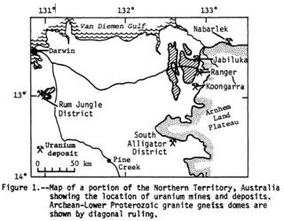
Alligator Rivers is the name of an area in an Arnhem Land region of the Northern Territory of Australia, containing three rivers, the East, West, and South Alligator Rivers. It is regarded as one of the richest biological regions in Australia, with part of the region in the Kakadu National Park. It is an Important Bird Area (IBA), lying to the east of the Adelaide and Mary River Floodplains IBA. It also contains mineral deposits, especially uranium, and the Ranger Uranium Mine is located there. The area is also rich in Australian Aboriginal art, with 1500 sites. The Kakadu National Park is one of the few World Heritage sites on the list because of both its natural and human heritage values. They were explored by Lieutenant Phillip Parker King in 1820, who named them in the mistaken belief that the crocodiles in the estuaries were alligators.

In Australia and New Zealand, a cattle station is a large farm, the main activity of which is the rearing of cattle. The owner of a cattle station is called a grazier. The largest cattle station in the world is Anna Creek Station in South Australia, which covers an area of 23,677 square kilometres.

The Herbert River is a river in Far North Queensland, Australia. The southernmost of Queensland's wet tropics river systems, it was named in 1864 by George Elphinstone Dalrymple explorer, after Robert George Wyndham Herbert, the first Premier of Queensland.

The Georgina River is the north-westernmost of the three major rivers of the Channel Country in Central West Queensland, that also flows through a portion of the Northern Territory, in central Australia. Part of the Lake Eyre basin, the Georgina flows in extremely wet years into Lake Eyre.
The Sturt River, also known as the Sturt Creek and Warri Parri (Warriparri) in the Kaurna language, is a river located in the Adelaide region of the Australian state of South Australia.

Wilsons River, a perennial river and part of the Richmond River catchment, is situated in the Northern Rivers district of New South Wales, Australia.
The Calvert River is a river in the Northern Territory of Australia.
The Wickham River is an ephemeral river, located in the Victoria Bonaparte bioregion of the Northern Territory in Australia.
The Moyle River is a river in the Northern Territory, Australia.
The Goyder River is a river in the Northern Territory of Australia.
The Limmen Bight River is a river in the Northern Territory, Australia.
The Settlement Creek is a creek in the Northern Territory and the state of Queensland, Australia.
The Nicholson River is a river in the Northern Territory and the state of Queensland, Australia.

The Gregory River is a river in the Northern Territory and the state of Queensland, Australia. The river is the largest perennial river in arid and semi-arid Queensland, one of the few permanently flowing rivers in the northwest of Queensland.

