Goomadeer River

Last updated

Goomadeer
Australia Northern Territory relief location map.png
Red pog.svg
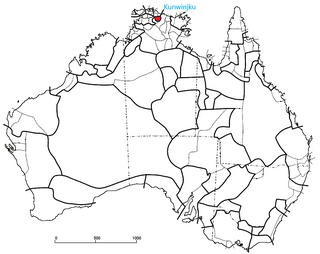
Location of the Goomadeer River mouth in the Northern Territory
Etymologyfrom Kunwinjku 'Kumardderr'
Location
Country Australia
Territory Northern Territory
Physical characteristics
Source 
  elevation274 m (899 ft)
Mouth Junction Bay
  location
Australia
  coordinates
11°50′56″S133°49′30″E / 11.84889°S 133.82500°E / -11.84889; 133.82500 Coordinates: 11°50′56″S133°49′30″E / 11.84889°S 133.82500°E / -11.84889; 133.82500
  elevation
0 m (0 ft)
Length138 km (86 mi)
Basin size5,684 km2 (2,195 sq mi)
Discharge 
  average36.1 m3/s (1,270 cu ft/s)
Basin features
Tributaries 
  rightGumardir River
[1] [2]

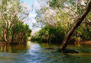
The Goomadeer River is a river in the Northern Territory, Australia.

River Natural flowing watercourse

A river is a natural flowing watercourse, usually freshwater, flowing towards an ocean, sea, lake or another river. In some cases a river flows into the ground and becomes dry at the end of its course without reaching another body of water. Small rivers can be referred to using names such as stream, creek, brook, rivulet, and rill. There are no official definitions for the generic term river as applied to geographic features, although in some countries or communities a stream is defined by its size. Many names for small rivers are specific to geographic location; examples are "run" in some parts of the United States, "burn" in Scotland and northeast England, and "beck" in northern England. Sometimes a river is defined as being larger than a creek, but not always: the language is vague.

Northern Territory Federal territory of Australia

The Northern Territory is an Australian territory in the central and central northern regions of Australia. It shares borders with Western Australia to the west, South Australia to the south, and Queensland to the east. To the north, the territory looks out to the Timor Sea, the Arafura Sea and the Gulf of Carpentaria, including Western New Guinea and other Indonesian islands. The NT covers 1,349,129 square kilometres (520,902 sq mi), making it the third-largest Australian federal division, and the 11th-largest country subdivision in the world. It is sparsely populated, with a population of only 245,800, fewer than half as many people as Tasmania.

Australia Country in Oceania

Australia, officially the Commonwealth of Australia, is a sovereign country comprising the mainland of the Australian continent, the island of Tasmania, and numerous smaller islands. It is the largest country in Oceania and the world's sixth-largest country by total area. The neighbouring countries are Papua New Guinea, Indonesia, and East Timor to the north; the Solomon Islands and Vanuatu to the north-east; and New Zealand to the south-east. The population of 26 million is highly urbanised and heavily concentrated on the eastern seaboard. Australia's capital is Canberra, and its largest city is Sydney. The country's other major metropolitan areas are Melbourne, Brisbane, Perth, and Adelaide.

Contents

Etymology

The name comes from the Kunwinjku Kumardderr, which is the name of an area that the river flows through. [3]

Kunwinjku, also known by the cover term Bininj Gunwok or Mayali, is an Australian Aboriginal language in northern Australia. The Bininj people live primarily in western Arnhem Land. There are perhaps two thousand fluent speakers in an area roughly bounded by Kakadu National Park to the west, the Arafura Sea to the north, the Blyth River to the east, and the Katherine region to the south.

Description

The headwaters are located on the sandstone plateau fed by springs [4] in Arnhem Land at an elevation of 274 metres (899 ft) and flows in a northerly direction through mostly uninhabited lands and eventually discharges into Junction Bay and the Arafura Sea. The only tributary of the river is the Gumardir River.

Arnhem Land Region in the Northern Territory, Australia

Arnhem Land is one of the five regions of the Northern Territory of Australia. It is located in the north-eastern corner of the territory and is around 500 km (310 mi) from the territory capital, Darwin. The region has an area of 97,000 km2 (37,000 sq mi), which borders Kakadu National Park, and has a population of 16,230. In 1623, Dutch East India Company captain William van Colster sailed into the Gulf of Carpentaria and Cape Arnhem is named after his ship, the Arnhem, which itself was named after the city of Arnhem in the Netherlands.

Arafura Sea Marginal sea between Australia and Indonesian New Guinea

The Arafura Sea lies west of the Pacific Ocean, overlying the continental shelf between Australia and Indonesian New Guinea.

Tributary stream or river that flows into a main stem river or lake

A tributary or affluent is a stream or river that flows into a larger stream or main stem river or a lake. A tributary does not flow directly into a sea or ocean. Tributaries and the main stem river drain the surrounding drainage basin of its surface water and groundwater, leading the water out into an ocean.

The estuary formed at the river mouth is in near pristine condition and occupies an area of 24.9 hectares (62 acres) of open water. It is riverdominated in nature with a tide dominated delta having a single channel and is surrounded by an area of 11.2 square kilometres (4 sq mi) covered with mangroves. [5]

Estuary A partially enclosed coastal body of brackish water with one or more rivers or streams flowing into it, and with a free connection to the open sea

An estuary is a partially enclosed coastal body of brackish water with one or more rivers or streams flowing into it, and with a free connection to the open sea.

Mangrove A shrub or small tree that grows in coastal saline or brackish water

A mangrove is a shrub or small tree that grows in coastal saline or brackish water. The term is also used for tropical coastal vegetation consisting of such species. Mangroves occur worldwide in the tropics and subtropics, mainly between latitudes 25° N and 25° S. The total mangrove forest area of the world in 2000 was 137,800 square kilometres (53,200 sq mi), spanning 118 countries and territories.

The catchment occupies an area of 5,684 square kilometres (2,195 sq mi) and is situated between the East Alligator River catchment to the west and the Liverpool River catchment to the east. [2] It has an annual discharge of 1,140 gigalitres (1.491×10⁹ cu yd). [6]

Liverpool River Australian river

Liverpool River is a river in the Northern Territory of Australia. It is largest of the tidal river systems of northern Arnhem Land, which includes two major tributaries, the Tomkinson and Mann Rivers.

Flora and fauna

The riparian vegetation of the river is in good condition but are declining as a result of the proliferation of feral pigs and buffalo and the invasion of some weed species. [7]

Feral Animal or plant living in the wild but descended from domesticated ancestors

A feral animal or plant is one that lives in the wild but is descended from domesticated individuals.

19 species of fish are found in the river including; the Macleay's Glassfish, Barred Grunter, Sooty Grunter, Fly-specked Hardyhead, Northern Trout Gudgeon, Gulf Saratoga, Barramundi, Oxeye Herring, Rainbowfish, Black-banded Rainbowfish, Bony Bream, Catfish, Freshwater Longtom, Seven-spot Archerfish and the Sleepy Cod. [8]

The pig-nosed turtle, a threatened species of turtle, is known to inhabit sections of the river, but only in small populations. [9]

See also

Related Research Articles

Kakadu National Park Protected area in the Northern Territory, Australia

Kakadu National Park is a protected area in the Northern Territory of Australia, 171 km southeast of Darwin.

Alligator Rivers estuary

Alligator Rivers is the name of an area in an Arnhem Land region of the Northern Territory of Australia, containing three rivers, the East, West, and South Alligator Rivers. It is regarded as one of the richest biological regions in Australia, with part of the region in the Kakadu National Park. It is an Important Bird Area (IBA), lying to the east of the Adelaide and Mary River Floodplains IBA. It also contains mineral deposits, especially uranium, and the Ranger Uranium Mine is located there. The area is also rich in Australian Aboriginal art, with 1500 sites. The Kakadu National Park is one of the few World Heritage sites on the list because of both its natural and human heritage values. They were explored by Lieutenant Phillip Parker King in 1820, who named them in the mistaken belief that the crocodiles in the estuaries were alligators.

Black wallaroo species of mammal

The black wallaroo, Bernard's wallaroo or Woodward's wallaroo, is a species of macropod restricted to a small, mountainous area in Arnhem Land, Northern Territory, Australia, between South Alligator River and Nabarlek. It classified as near threatened, mostly due to its limited distribution. A large proportion of the range is protected by Kakadu National Park.

Jim Jim Falls waterfall

The Jim Jim Falls is a plunge waterfall on the Jim Jim Creek that descends over the Arnhem Land escarpment within the UNESCO World Heritage–listed Kakadu National Park in the Northern Territory of Australia. The Jim Jim Falls area is registered on the Australian National Heritage List.

Mary River (Northern Territory) river in the Northern Territory, Australia

The Mary River flows in the Northern Territory of Australia and is a site of the Mary River National Park.

The Arafura Swamp is a large inland freshwater wetland in Arnhem Land, in the Top End of the Northern Territory of Australia. It is a near pristine floodplain with an area of 700 square kilometres (270 sq mi) that may expand to 1,300 km2 (500 sq mi) by the end of the wet season, making it the largest wooded swamp in the Northern Territory and, possibly, in Australia. It has a strong seasonal variation in depth of water. The area is of great cultural significance to the Yolngu people, in particular the Ramingining community. It was the filming location for the film Ten Canoes.

Fitzmaurice River river in Australia

The Fitzmaurice River is a river in Australia's Northern Territory.

Calvert River river in the Northern Territory, Australia

The Calvert River is a river in the Northern Territory of Australia.

Gunwinggu Australian Aboriginal tribe

The Gunwinggu (Kunwinjku) people are a tribe of Australian Aboriginal people, forming part of the Bininj Gun-Wok peoples, who live around West Arnhem Land to the east of Darwin, Northern Territory. Kunwinjku people generally refer to themselves as 'Bininj' in much the same way that Yolŋu people refer to themselves as 'Yolŋu'.

Buckingham River river in Australia

Buckingham River is a river in the Northern Territory of Australia.

Keep River river in Australia

The Keep River is a river, located in the Victoria Bonaparte bioregion of Western Australia and the Northern Territory in Australia.

Blyth River (Northern Territory) river in Australia

The Blyth River is a river in the Northern Territory, Australia.

Moyle River river in Australia

The Moyle River is a river in the Northern Territory, Australia.

Goyder River River in Australia

The Goyder River is a river in the Northern Territory, Australia.

Walker River (Northern Territory) river in Australia

The Walker River is a river in the Northern Territory, Australia.

Towns River river in Australia

The Towns River is a river in the Northern Territory, Australia.

Robinson River (Northern Territory) river in Northern Territory, Australia

The Robinson River is a river in Australia's Northern Territory.

Settlement Creek river in Australia

The Settlement Creek is a creek located in the Northern Territory and the state of Queensland, Australia.

References

  1. "Map of Goomadeer River, NT". Bonzle Digital Atlas of Australia. Retrieved 9 May 2015.
  2. 1 2 "Drainage Divisions" (PDF). Commonwealth of Australia. 2005. Archived from the original (PDF) on 1 April 2015. Retrieved 9 May 2015.
  3. Garde, Murray. "Kumardderr". Bininj Kunwok Dictionary. Bininj Kunwok Regional Language Centre. Retrieved 16 June 2019.
  4. U. Zaar (2003). "Water Resources of West Arnhem Land" (PDF). Department of Infrastructure, Planning and Environment. Retrieved 9 May 2015.
  5. "Goomadeer River, NT". Australian online Coastal Information. Commonwealth of Australia . Retrieved 24 May 2015.
  6. S. Larson and K. Alexandridis (2009). "Goomadeer River" (PDF). TRaCK. Retrieved 9 May 2015.
  7. "Arnhem Coast - Bioregional description". Northern Territory Government. Archived from the original on 1 April 2015. Retrieved 10 May 2015.
  8. "Goomadeer River catchment". Fish Atlas of North Australia. Retrieved 10 May 2015.
  9. "Pig-nosed Turtle (Carettochelys insculpta)". Department of the Environment. 13 July 2005. Retrieved 10 May 2015.