| King | |
|---|---|
| Location | |
| Country | Australia |
| State | Northern Territory |
| Region | Katherine Region |
| Basin features | |
| River system | Daly River |
| Tributaries | |
| • right | Dry River |
The King River is a river in the Northern Territory of Australia. It is a tributary of the Daly River which ultimately flows into the Timor Sea.
The Dry River is a tributary of the King River.
A telemetered gauging station is located on the river downstream from the Victoria Highway crossing. The maximum recorded flood height at this station was 13.959 m on 11 March 1974. [1] It was originally used to investigate the water resources of the Northern Territory. It is now used as a flood warning site.

The Yakima River is a tributary of the Columbia River in south central and eastern Washington state, named for the indigenous Yakama people. The length of the river from headwaters to mouth is 214 miles (344 km), with an average drop of 9.85 feet per mile (1.866 m/km). It is the longest river entirely in Washington state.

The Upper Rhine is the section of the Rhine in the Upper Rhine Plain between Basel in Switzerland and Bingen in Germany. The river is marked by Rhine-kilometres 170 to 529.
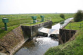
A stream gauge, streamgage or stream gauging station is a location used by hydrologists or environmental scientists to monitor and test terrestrial bodies of water. Hydrometric measurements of water level surface elevation ("stage") and/or volumetric discharge (flow) are generally taken and observations of biota and water quality may also be made. The location of gauging stations are often found on topographical maps. Some gauging stations are highly automated and may include telemetry capability transmitted to a central data logging facility.

The Mackenzie River is a river in the Canadian boreal forest. It is the longest river system in Canada, and includes the second largest drainage basin of any North American river after the Mississippi.

Murrumbidgee River, a major tributary of the Murray River within the Murray–Darling basin and the second longest river in Australia. It flows through the Australian state of New South Wales and the Australian Capital Territory. It descends 1,500 metres (4,900 ft) as it flows 1,485 kilometres (923 mi) in a west-northwesterly direction from the foot of Peppercorn Hill in the Fiery Range of the Snowy Mountains towards its confluence with the Murray River near Boundary Bend.
The Finke River, or Larapinta (Arrernte), is a river in central Australia, one of four main rivers of the Lake Eyre Basin and thought to be the oldest riverbed in the world. It flows for only a few days a year and when this happens, its water usually disappears into the sands of the Simpson Desert, rarely if ever reaching Lake Eyre.

The Huai River, formerly romanized as the Hwai, is a major river in China. It is located about midway between the Yellow River and Yangtze, the two largest rivers in China, and like them runs from west to east. Historically draining directly into the Yellow Sea, floods have changed the course of the river such that it is now a major tributary of the Yangtze. The Huai is notoriously vulnerable to flooding.

The Todd River is an ephemeral river in the southern Northern Territory, central Australia. The origins of the Todd River are in the MacDonnell Ranges, where it flows past the Telegraph Station, almost through the centre of Alice Springs, through Heavitree Gap at the southern end of Alice Springs and continuing on for some distance, passing through the western part of the Simpson Desert, as it becomes a tributary of the Hale River, and eventually flowing into Lake Eyre in South Australia.
Katherine River is located in the Northern Territory, Australia. Its headwaters are in Nitmiluk National Park, it flows through the town of Katherine, and is a major tributary of the Daly River. The Katherine River drops around 384m over its 328 km length.

The Barron River is located on the Atherton Tablelands inland from Cairns in northern Queensland, Australia. With its headwaters below Mount Hypipamee, the 165-kilometre (103 mi)-long river with a catchment area of approximately 2,138 square kilometres (825 sq mi) forms through run off from the Mount Hypipamee National Park, flows through Lake Tinaroo, and eventually empties into the Coral Sea near Smithfield.

The Herbert River is a river located in Far North Queensland, Australia. The southernmost of Queensland's wet tropics river systems, it was named in 1864 by George Elphinstone Dalrymple explorer, after Robert George Wyndham Herbert, the first Premier of Queensland.

The Pioneer River is a river located in North Queensland, Australia. The 120-kilometre (75 mi) long river flows through the city of Mackay.

The Georgina River is the north-westernmost of the three major rivers of the Channel Country in Central West Queensland, that also flows through a portion of the Northern Territory, in central Australia. Part of the Lake Eyre basin, the Georgina flows in extremely wet years into Lake Eyre.

The Dry River is a river in the Northern Territory of Australia.
The McArthur River is a river in the Northern Territory of Australia which flows into the Gulf of Carpentaria at Port McArthur, opposite the Sir Edward Pellew Group of Islands. The river was named by Ludwig Leichhardt while he explored the area in 1845. He named the River after James MacArthur and the MacArthur family of Camden, who were enthusiastic supporters of his expedition. The McArthur River has significance for the local Aboriginal communities, who use it for fishing and other traditional activities.

The Maranoa River, part of the Murray-Darling basin, is a river situated in South West Queensland, Australia.

Wilsons River, a perennial river and part of the Richmond River catchment, is situated in the Northern Rivers district of New South Wales, Australia.

The Don River is a river located in North Queensland, Australia.
The Nicholson River is a river located in the Northern Territory and the state of Queensland, Australia.
The Frew River is an ephemeral river in the Northern Territory of Australia.
River systems and rivers of the Northern Territory, Australia | |
|---|---|
| Floodplains | |
| Rivers |
|
Coordinates: 14°41′42″S131°58′49″E / 14.6950°S 131.9803°E