Wickham River

Last updated

Wickham
Australia Northern Territory relief location map.png
Red pog.svg
Location of the Wickham River mouth in the Northern Territory
Etymology John Clements Wickham [1]
Location
Country Australia
Territory Northern Territory
Region Victoria Bonaparte (IBRA)
Physical characteristics
SourceMount Kimon
  elevation330 m (1,080 ft)
Mouth Victoria River
  coordinates
17°01′31″S129°57′52″E / 17.02528°S 129.96444°E / -17.02528; 129.96444 Coordinates: 17°01′31″S129°57′52″E / 17.02528°S 129.96444°E / -17.02528; 129.96444
  elevation
74 m (243 ft)
Length198 km (123 mi)
Basin size5,018 km2 (1,937 sq mi)
Discharge 
  average11.9 m3/s (420 cu ft/s)
Basin features
Tributaries 
  leftMidnight Creek, Broadarrow Creek, Cusack Creek, Humbert River
  rightSoda Springs Creek, Depot Creek (Northern Territory), Gibbie Creek
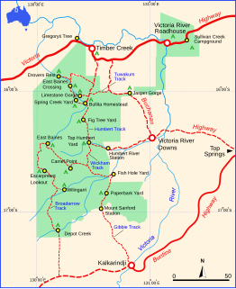
National park Judbarra / Gregory NP
[2] [3]

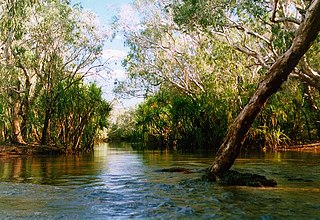
The Wickham River is an ephemeral river, located in the Victoria Bonaparte bioregion of the Northern Territory in Australia.

River Natural flowing watercourse

A river is a natural flowing watercourse, usually freshwater, flowing towards an ocean, sea, lake or another river. In some cases a river flows into the ground and becomes dry at the end of its course without reaching another body of water. Small rivers can be referred to using names such as stream, creek, brook, rivulet, and rill. There are no official definitions for the generic term river as applied to geographic features, although in some countries or communities a stream is defined by its size. Many names for small rivers are specific to geographic location; examples are "run" in some parts of the United States, "burn" in Scotland and northeast England, and "beck" in northern England. Sometimes a river is defined as being larger than a creek, but not always: the language is vague.

Victoria Bonaparte Region in Australia

The Victoria Bonaparte, an interim Australian bioregion, is located in the Northern Territory and Western Australia, comprising 7,301,242 hectares.

A bioregion is an ecologically and geographically defined area that is smaller than an ecozone, but larger than an ecoregion or an ecosystem, in the World Wildlife Fund classification scheme. There is also an attempt to use the term in a rank-less generalist sense, similar to the terms "biogeographic area" or "biogeographic unit".

Contents

Course and features

The headwaters of the Wickham River are situated on an area of rugged stony hills and a sandstone plateau [3] as the river rises on the southeastern slopes of Mt Kimon. It flows generally northeast, joined by seven tributaries including the Humbert River, Soda Springs Creek, Depot Creek and Broadarrow Creek and through one permanent waterhole, Johnston Billabong, before reaching its confluence with the Victoria River, south of the Fitzgerald Range near Pompey Knob. The Wickham River descends 256 metres (840 ft) over its 198-kilometre (123 mi) course. [2]

Sandstone A clastic sedimentary rock composed mostly of sand-sized particles

Sandstone is a clastic sedimentary rock composed mainly of sand-sized mineral particles or rock fragments.

Tributary stream or river that flows into a main stem river or lake

A tributary or affluent is a stream or river that flows into a larger stream or main stem river or a lake. A tributary does not flow directly into a sea or ocean. Tributaries and the main stem river drain the surrounding drainage basin of its surface water and groundwater, leading the water out into an ocean.

Billabong Australian term for a seasonal oxbow lake

A billabong is an Australian term for an oxbow lake, an isolated pond left behind after a river changes course. Billabongs are usually formed when the path of a creek or river changes, leaving the former branch with a dead end. As a result of the arid Australian climate in which these "dead rivers" are found, billabongs fill with water seasonally; they are dry for a greater part of the year.

The Judbarra / Gregory National Park was established in 1981 encompassing much of the catchment. Mount Sanford was exhumed to enlarge the park boundaries in 1996. [3]

Judbarra / Gregory National Park Protected area in the Northern Territory, Australia

Judbarra National Park, formerly Gregory National Park, is a national park in the Northern Territory (Australia), 359 km south of Darwin.

Drainage basin Area of land where precipitation collects and drains off into a common outlet

A drainage basin is any area of land where precipitation collects and drains off into a common outlet, such as into a river, bay, or other body of water. The drainage basin includes all the surface water from rain runoff, snowmelt, and nearby streams that run downslope towards the shared outlet, as well as the groundwater underneath the earth's surface. Drainage basins connect into other drainage basins at lower elevations in a hierarchical pattern, with smaller sub-drainage basins, which in turn drain into another common outlet.

The Wickham flows for only six months of the year, during the wet season. During the dry season, a string of waterholes form along the course of the river some of which are spring-fed and almost permanent. [3]

Wet season yearly period of high rainfall, especially in the tropics

The wet season is the time of year when most of a region's average annual rainfall occurs. Generally the season lasts at least a month. The term "green season" is also sometimes used as a euphemism by tourist authorities. Areas with wet seasons are dispersed across portions of the tropics and subtropics.

The dry season is a yearly period of low rainfall, especially in the tropics. The weather in the tropics is dominated by the tropical rain belt, which moves from the northern to the southern tropics and back over the course of the year. The tropical rain belt lies in the southern hemisphere roughly from October to March; during that time the northern tropics have a dry season with sparser precipitation, and days are typically sunny throughout. From April to September, the rain belt lies in the northern hemisphere, and the southern tropics have their dry season. Under the Köppen climate classification, for tropical climates, a dry season month is defined as a month when average precipitation is below 60 millimetres (2.4 in).

When Lawrence Wells started his trigonometric survey of the Northern Territory in 1905 he formed his depot on the Wickham River not too far from Victoria River Downs Station homestead. [4]

Lawrence Wells Australian explorer

Lawrence Allen "Larry" Wells, frequently spelled Laurence Allen Wells, was an Australian explorer.

Victoria River Downs Station

Victoria River Downs Station also often called Victoria Downs and often referred to as The Big Run is a pastoral lease that operates as a cattle station.

The area surrounding the Wickham River are the traditional lands of the Aboriginal community of Yarralin, also known as Walangeri. [5]

Yarralin, Northern Territory Town in the Northern Territory, Australia

Yarralin, also known as Walangeri is a remote Aboriginal community in the Northern Territory of Australia. At the 2011 census, Yarralin had a population of 266. The community is located on the banks of the Wickham River, about 15 km (9.3 mi) west of Victoria River Downs, a major cattle station along the Buchanan Highway.

Etymology

The river is named in honour of Captain John Clements Wickham who sailed up the 200 kilometres (124 mi) Victoria River in 1839 aboard HMS Beagle. [1]

See also

Related Research Articles

The protected areas of the Northern Territory consists of protected areas managed by the governments of the Northern Territory and Australia and private organisations with a reported total area of 335,527 square kilometres (129,548 sq mi) being 24.8% of the total area of the Northern Territory of Australia.

Adelaide River river

The Adelaide River is a river in the Northern Territory of Australia.

Cooper Creek river

The Cooper Creek is one of the most famous rivers in Australia because it was the site of the death of the explorers Burke and Wills in 1861. It is sometimes known as the Barcoo River from one of its tributaries and is one of three major Queensland river systems that flow into the Lake Eyre basin. The flow of the creek depends on monsoonal rains falling months earlier and many hundreds of kilometres away in eastern Queensland. At 1,300 kilometres (810 mi) in length it is the second longest inland river system in Australia after the Murray-Darling system.

Avoca River river in Victoria, Australia

The Avoca River, an inland intermittent river of the north–central catchment, part of the Murray-Darling basin, is located in the lower Riverina bioregion and Central Highlands and Wimmera regions of the Australian state of Victoria. The headwaters of the Avoca River rise on the northern slopes of the Pyrenees Range and descend to flow into the ephemeral Kerang Lakes.

Warrego River river in Australia

The Warrego River, an intermittent river that is part of the Darling catchment within the Murray–Darling basin, is located in the south west of Queensland and in the Orana region of New South Wales, Australia. The Warrego River is northernmost tributary of the Darling River.

Flinders River river in Queensland, Australia

The Flinders River is the longest river in Queensland, Australia, at approximately 1,004 kilometres (624 mi). It was named in honour of the explorer Matthew Flinders. The catchment is sparsely populated and mostly undeveloped. The Flinders rises on the western slopes of the Great Dividing Range in North West Queensland and flows generally north-west through the Gulf Country, across a large, flat clay pan, before entering the Gulf of Carpentaria.

Victoria River (Northern Territory) river in the Northern Territory, Australia

The Victoria River is a river in the Victoria Bonaparte bioregion of the Northern Territory, Australia.

Dry River (Northern Territory) river in Australia

The Dry River is a river in the Northern Territory of Australia.

Roper River river in Australia

The Roper River is a large perennial river located in the Katherine region of the Northern Territory of Australia.

Ginninderra Creek river in Australia

Ginninderra Creek, a partly perennial stream of the Murrumbidgee catchment within the Murray-Darling basin, is located in the Capital Country region spanning both the Australian Capital Territory and New South Wales, Australia.

Calvert River river in the Northern Territory, Australia

The Calvert River is a river in the Northern Territory of Australia.

Merri River river in Victoria, Australia

The Merri River, a perennial river of the Glenelg Hopkins catchment, is located in the Western District of Victoria, Australia.

Arnold River (Northern Territory) river in Australia

The Arnold River is a river in the north of the Northern Territory of Australia.

Wildman River river in Australia

The Wildman River is a river in the Darwin Coastal bioregion of the Northern Territory, Australia.

Moyle River river in Australia

The Moyle River is a river in the Northern Territory, Australia.

Goyder River River in Australia

The Goyder River is a river in the Northern Territory, Australia.

Limmen Bight River river in Australia

The Limmen Bight River is a river in the Northern Territory, Australia.

Settlement Creek river in Australia

The Settlement Creek is a creek located in the Northern Territory and the state of Queensland, Australia.

Gregory River (Australia) River in Queensland, Australia

The Gregory River is a river located in the Northern Territory and the state of Queensland, Australia. The river is the largest perennial river in arid and semi-arid Queensland, one of the few permanently flowing rivers in the northwest of Queensland.

References

  1. 1 2 "Victoria River Downs (VRD) - The Big Run". Flinders Ranges Research. Retrieved 30 April 2015.
  2. 1 2 "Map of Wickham River, NT". Bonzle Digital Atlas of Australia. Retrieved 30 April 2015.
  3. 1 2 3 4 "Overview of the Victoria River Catchment" (PDF). Top End Waterways Project. Government of the Northern Territory. Retrieved 30 April 2015.
  4. "Lands and Survey Branches". National Archives of Australia . Retrieved 30 April 2015.
  5. "Yarralin". Katherine West Health Board Aboriginal Corporation. Retrieved 30 April 2015.