Blyth | |
---|---|
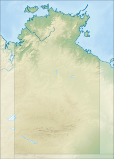
Location of the Blyth River mouth in the Northern Territory | |
Etymology | Arthur Blyth [1] |
Location | |
Country | Australia |
Territory | Northern Territory |
Region | Arnhem Land |
Physical characteristics | |
Source | |
⁃ location | Arnhem Land, Australia |
⁃ elevation | 194 m (636 ft) |
Mouth | |
⁃ location | Boucaut Bay, Timor Sea, Australia |
⁃ coordinates | 12°8′45″S134°35′20″E / 12.14583°S 134.58889°E Coordinates: 12°8′45″S134°35′20″E / 12.14583°S 134.58889°E |
⁃ elevation | 0 m (0 ft) |
Length | 175 km (109 mi) |
Basin size | 9,219 km2 (3,559 sq mi) |
Discharge | |
⁃ average | 58.9 m3/s (2,080 cu ft/s) |
Basin features | |
Tributaries | |
⁃ left | Shadforth Creek, Saddlers Creek, Immibar Creek, Cadell River |
⁃ right | Guyuyu Creek, Rangaburu Creek |
[2] |
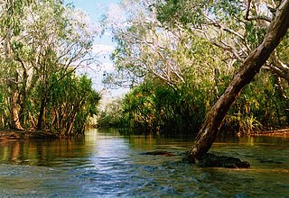
The Blyth River is a river in the Northern Territory, Australia.
A river is a natural flowing watercourse, usually freshwater, flowing towards an ocean, sea, lake or another river. In some cases a river flows into the ground and becomes dry at the end of its course without reaching another body of water. Small rivers can be referred to using names such as stream, creek, brook, rivulet, and rill. There are no official definitions for the generic term river as applied to geographic features, although in some countries or communities a stream is defined by its size. Many names for small rivers are specific to geographic location; examples are "run" in some parts of the United States, "burn" in Scotland and northeast England, and "beck" in northern England. Sometimes a river is defined as being larger than a creek, but not always: the language is vague.
The Northern Territory is an Australian territory in the central and central northern regions of Australia. It shares borders with Western Australia to the west, South Australia to the south, and Queensland to the east. To the north, the territory looks out to the Timor Sea, the Arafura Sea and the Gulf of Carpentaria, including Western New Guinea and other Indonesian islands. The NT covers 1,349,129 square kilometres (520,902 sq mi), making it the third-largest Australian federal division, and the 11th-largest country subdivision in the world. It is sparsely populated, with a population of only 245,800, fewer than half as many people as Tasmania.
Australia, officially the Commonwealth of Australia, is a sovereign country comprising the mainland of the Australian continent, the island of Tasmania, and numerous smaller islands. It is the largest country in Oceania and the world's sixth-largest country by total area. The neighbouring countries are Papua New Guinea, Indonesia, and East Timor to the north; the Solomon Islands and Vanuatu to the north-east; and New Zealand to the south-east. The population of 25 million is highly urbanised and heavily concentrated on the eastern seaboard. Australia's capital is Canberra, and its largest city is Sydney. The country's other major metropolitan areas are Melbourne, Brisbane, Perth, and Adelaide.
The headwaters rise east of Shadforth Hills and flows in a northerly direction through mostly uninhabited country, past the small community of Gamardi before discharging into Boucaut Bay. [2]
The catchment occupies an area of 9,219 square kilometres (3,559 sq mi) and is situated between the Liverpool River catchment to the west, the Goyder River catchment to the east and the Roper River catchment to the south. [3] It has a mean annual outflow of 1,860 gigalitres (2.433×10⁹ cu yd), [4]
Liverpool River is a river in the Northern Territory of Australia. It is largest of the tidal river systems of northern Arnhem Land, which includes two major tributaries, the Tomkinson and Mann Rivers.
The Goyder River is a river in the Northern Territory, Australia.
The Roper River is a large perennial river located in the Katherine region of the Northern Territory of Australia.
The Cadell and Blyth Floodplains are located at the lower reaches of the river and occupy an area of 432 square kilometres (167 sq mi).
The Cadell and Blyth Floodplains consist of the 432 square kilometres (167 sq mi) floodplain of the lower reaches of the Blyth and Cadell Rivers of northern Arnhem Land in the Top End of the Northern Territory of Australia. It is an important site for waterbirds.
The estuary formed at the river mouth is tidal in nature and in near pristine condition. [5]
An estuary is a partially enclosed coastal body of brackish water with one or more rivers or streams flowing into it, and with a free connection to the open sea.
The river was named by Francis Cadell in 1867 after the Premier of South Australia, Arthur Blyth. [1]
Francis William Cadell was a European explorer of Australia, most remembered for opening the Murray River up for transport by steamship and for his activities as a slave trader.
The Premier of South Australia is the head of government in the state of South Australia, Australia. The Government of South Australia follows the Westminster system, with a Parliament of South Australia acting as the legislature. The Premier is appointed by the Governor of South Australia, and by modern convention holds office by virtue of his or her ability to command the support of a majority of members of the lower house of Parliament, the House of Assembly.
Sir Arthur Blyth was Premier of South Australia three times; 1864–65, 1871–72 and 1873–75.
David Lindsay charted the river in 1883 during his expedition of Arnhem Land.
Many species of fish are found in the river including Sailfin Glassfish, Macleay's Glassfish, Barred Grunter, Fly-specked Hardyhead and Pennyfish, Goby, Flathead Goby, Giant Gudgeon, Empire Gudgeon, Threadfin Rainbowfish, Barramundi, Diamond Mullet, Rainbowfish, Western Rainbowfish, Black-banded Rainbowfish, Chequered Rainbowfish, Bony Bream, Black Catfish, Rendahl's Catfish, Seven-spot Archerfish. [6]
The Mary River flows in the Northern Territory of Australia and is a site of the Mary River National Park.
The Jardine River is the largest river of the Cape York Peninsula in Far North Queensland, Australia.
The Archer River is a river located on the Cape York Peninsula, Far North Queensland, Australia.
The Fitzmaurice River is a river in Australia's Northern Territory.
The Calvert River is a river in the Northern Territory of Australia.
The Keep River is a river, located in the Victoria Bonaparte bioregion of Western Australia and the Northern Territory in Australia.
The Moyle River is a river in the Northern Territory, Australia.
The Goomadeer River is a river in the Northern Territory, Australia.
The Towns River is a river in the Northern Territory, Australia.
The Limmen Bight River is a river in the Northern Territory, Australia.
The Rosie River also known as Rosie Creek is a river in the Northern Territory, Australia.
The Robinson River is a river in Australia's Northern Territory.
The Settlement Creek is a creek located in the Northern Territory and the state of Queensland, Australia.
The Watson River is a river located in Far North Queensland, Australia.
The Coleman River is a river located on the Cape York Peninsula in Far North Queensland, Australia.
The Black River is a river located in North Queensland, Australia.
The Haughton River is a river located in North Queensland, Australia.
The Jackey Jackey Creek, also often called Jacky Jacky Creek, is a creek located in the Cape York Peninsula region of Far North Queensland, Australia.