
Central Queensland is an imprecisely-defined geographical division of Queensland that centres on the eastern coast, around the Tropic of Capricorn. Its major regional centre is Rockhampton. The region extends from the Capricorn Coast west to the Central Highlands at Emerald, north to the Mackay Regional Council southern boundary, and south to Gladstone. The region is also known as Capricornia. It is one of Australia's main coal exporting regions.

Collarenebri is a town in north western New South Wales, Australia. The town is in the Walgett Shire Local Government Area and is situated on the Barwon River approximately 75 kilometres (47 mi) northeast of Walgett and south west of Mungindi on the Gwydir Highway. It is 16 km (9.9 mi) from Pokataroo which was the nearest railway town prior to closure of the rail service there. The town is 150 metres (490 ft) above sea level. Collarenebri is one of three towns ending in 'BRI' in Northern New South Wales.

Innamincka, formerly Hopetoun, is a township and locality in north-east South Australia. By air it is 820 kilometres north-east of the state capital, Adelaide, and 365 kilometres north-east of the closest town, Lyndhurst. It is 66 kilometres north-east of the Moomba Gas Refinery. The town lies within the Innamincka Regional Reserve and is surrounded by the Strzelecki Desert to the south and the Sturt Stony Desert to the north. It is linked by road to Lyndhurst via the Strzelecki Track, to the Birdsville Developmental Road via Cordillo Downs Road and Arrabury Road, and the Walkers Crossing Track to the Birdsville Track. The Walkers Crossing Track is closed in summer and only traversable in dry weather. The township is situated along the Cooper Creek, a part of the Lake Eyre basin.
North Queensland or the Northern Region is the northern part of the Australian state of Queensland that lies just south of Far North Queensland. Queensland is a massive state, larger than many countries, and its tropical northern part has been historically remote and undeveloped, resulting in a distinctive regional character and identity.
Warluwarra is an extinct Australian Aboriginal language of Queensland. Waluwarra has a traditional language region in the local government area of Shire of Boulia, including Walgra Station and Wolga, from Roxborough Downs north to Carandotta Station and Urandangi on the Georgina River, on Moonah Creek to Rochedale, south-east of Pituri Creek.
The Shire of Barcoo is a local government area in Central West Queensland, Australia. In June 2018, the shire had a population of 267 people.
The Shire of Diamantina is a local government area in Central West Queensland, bordering South Australia and the Northern Territory. Its administrative centre is in the town of Bedourie.

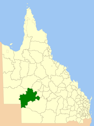
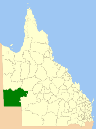
The Shire of Boulia is a local government area in Central West Queensland, bordering the Northern Territory. Its administrative centre is in the town of Boulia.

The Shire of Mckinlay is a local government area in outback north-western Queensland, Australia.

The Shire of Cook is a local government area in Far North Queensland, Australia. The Shire covers most of the eastern and central parts of Cape York Peninsula, the most northerly section of the Australian mainland.

The Outback Communities Authority (OCA) is a statutory authority in South Australia (SA) created under the Outback Communities Act 2009. It has been established to "manage the provision of public services and facilities to outback communities" which are widely dispersed across the Pastoral Unincorporated Area which covers almost 60% of South Australia's land area. The authority has its seat at both Port Augusta which is located outside the unincorporated area and at Andamooka. The authority serves an area of 624,339 square kilometres, slightly smaller than France. The area has a population of 3,750, of whom 639 are Indigenous Australians, and includes several large pastoral leases and mining operations.

The Aboriginal Shire of Doomadgee is a special local government area in North West Queensland, Queensland, Australia. It is managed under a Deed of Grant in Trust under the Local Government Act 2004.

The Barcaldine Region is a local government area in Central West Queensland, Australia. Established in 2008, it was preceded by three previous local government areas which had existed for over a century.

The Burke River is an ephemeral river in Central West Queensland, Australia. The river was named in memory of Robert O'Hara Burke of the Burke and Wills expedition.

The Wujal Wujal Aboriginal Shire is a local government area in Far North Queensland, Australia. It is managed as a Deed of Grant in Trust under the Local Government Act 2004.
Yandruwandha is an Australian Aboriginal language of the Pama–Nyungan family. Yawarawarga is considered a dialect by Dixon (2002), a closely related language by Bowern (2001). It is also known as Yawarrawarrka,Yawarawarka, Yawarawarga, Yawarawarka, Jauraworka, and Jawarawarka).
Waanyi, also spelt Wanyi, Wanji or Waanji, is an endangered Australian Aboriginal language spoken by the Waanyi people of the lower gulf area of Northern Queensland, Australia. Although earlier thought to be extinct, as of the 2016 Australian census there were 16 speakers of the language. This was down from the recorded peak of 40 in the 2011 Australian census.
Kungkari is an extinct and unclassified Australian Aboriginal language. The Kungkari language region included the landscape within the local government boundaries of the Longreach Shire Council and Blackall-Tambo Shire Council.
The Grey Range is a low-lying range of hills located in the Australian state of Queensland. The stretches from the west of Blackall of Central West Queensland in the north to Tibooburra in the far west of New South Wales.

Carrandotta is a locality in the Shire of Boulia, Queensland, Australia. It is on the border with the Northern Territory. In the 2021 census, Carrandotta had a population of 5 people.

