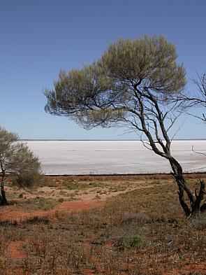
Lake Eyre, officially known as Kati Thanda–Lake Eyre, is an endorheic lake in the east-central part of the Far North region of South Australia, some 700 km (435 mi) north of Adelaide. The shallow lake is the depocentre of the vast endorheic Lake Eyre basin, and contains the lowest natural point in Australia, at approximately 15 m (49 ft) below sea level. On the rare occasions that it fills completely, it is the largest lake in Australia, covering an area of up to 9,500 km2 (3,668 sq mi). When the lake is full, it has the same salinity as seawater, but becomes hypersaline as the lake dries up and the water evaporates.

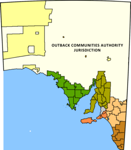
Andamooka is a town approximately 600 km north of Adelaide in the Far North of South Australia on the lands of the Kokatha people. Andamooka is the largest town administered by the Outback Communities Authority instead of a local government area. It is in the state electoral district of Giles and the federal Division of Grey.
The Lake Eyre basin is a drainage basin that covers just under one-sixth of all Australia. It is the largest endorheic basin in Australia and amongst the largest in the world, covering about 1,200,000 square kilometres (463,323 sq mi), including much of inland Queensland, large portions of South Australia and the Northern Territory, and a part of western New South Wales. The basin is also one of the largest, least-developed arid zone basins with a high degree of variability anywhere. It supports only about 60,000 people and has no major irrigation, diversions or flood-plain developments. Low density grazing that sustains a large amount of wildlife is the major land use, occupying 82% of the total land within the basin. The Lake Eyre basin of precipitation to a great extent geographically overlaps the Great Artesian Basin underneath.
Local government is the third level of government in Australia, administered with limited autonomy under the states and territories, and in turn beneath the federal government. Local government is not mentioned in the Constitution of Australia, and two referendums in 1974 and 1988 to alter the Constitution relating to local government were unsuccessful. Every state/territory government recognises local government in its own respective constitution. Unlike the two-tier local government system in Canada or the United States, there is only one tier of local government in each Australian state/territory, with no distinction between counties and cities.
The Finke River, or Larapinta in the Indigenous Arrernte language, is a river in central Australia, whose bed courses through the Northern Territory and the state of South Australia. It is one of the four main rivers of Lake Eyre Basin and is thought to be the oldest riverbed in the world. It flows for only a few days a year. When this happens, its water usually disappears into the sands of the Simpson Desert, rarely if ever reaching Lake Eyre.
Glendambo is a town and locality in the Australian state of South Australia located on the Stuart Highway about 592 kilometres (368 mi) from the state capital of Adelaide and about 254 kilometres (158 mi) from Coober Pedy.

Innamincka, formerly Hopetoun, is a township and locality in north-east South Australia. By air it is 820 kilometres north-east of the state capital, Adelaide, and 365 kilometres north-east of the closest town, Lyndhurst. It is 66 kilometres north-east of the Moomba Gas Refinery. The town lies within the Innamincka Regional Reserve and is surrounded by the Strzelecki Desert to the south and the Sturt Stony Desert to the north. It is linked by road to Lyndhurst via the Strzelecki Track, to the Birdsville Developmental Road via Cordillo Downs Road and Arrabury Road, and the Walkers Crossing Track to the Birdsville Track. The Walkers Crossing Track is closed in summer and only traversable in dry weather. The township is situated along the Cooper Creek, a part of the Lake Eyre basin.
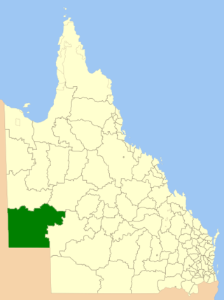
The Shire of Diamantina is a local government area in Central West Queensland, bordering South Australia and the Northern Territory. Its administrative centre is in the town of Bedourie.
Pimba is a small settlement lying on the transcontinental railway line in the Australian state of South Australia. It lies at the junction of the Stuart Highway to Alice Springs and the road to Woomera, Roxby Downs and Andamooka. It is 441 kilometres (274 mi) from Adelaide. There is an iconic roadhouse, named "Spud's Roadhouse", which sells fuel and general shop items and meals and has accommodation.
Kingoonya, originally spelt Kingoonyah, pronounced, was a small settlement, or township, now almost totally abandoned, in the central outback of the Australian state of South Australia. It was established in 1916 as a railway settlement on the Trans-Australian Railway, mainly to provide refuelling for steam trains and track maintenance services; it also served about 200 families living on sheep grazing properties in the region.

Yunta is a town and locality in the Australian state of South Australia located in the state's east about 275 kilometres (171 mi) north-east of the state capital of Adelaide. It is a service centre supporting both the local area and travellers passing through on the Barrier Highway. It lies south west of Broken Hill and north east of Peterborough.

Penong is a town and locality on the Nullarbor Plain, in the far west of the state of South Australia located about 616 kilometres (383 mi) north-west of the state capital of Adelaide. With no settlements between it and Border Village on the border with Western Australia, 400 km (250 mi) away on the Eyre Highway, it is a popular rest-stop for travellers.

Olary is a town and locality on the Barrier Highway in South Australia. It is situated near Olary Creek and is one of the easternmost settlements in South Australia. The name "Olary" was first given to a nearby well or waterhole by pastoralists Duffield, Harrold and Hurd.
Yandruwandha is an Australian Aboriginal language of the Pama–Nyungan family. Yawarawarga is considered a dialect by Dixon (2002), a closely related language by Bowern (2001). It is also known as Yawarrawarrka,Yawarawarka, Yawarawarga, Yawarawarka, Jauraworka, and Jawarawarka).

Western Queensland encompasses the three western regions in the Australian state of Queensland:

Macumba River, once known as Treuer River, is an ephemeral freshwater stream in the far north of South Australia, that is part of the Lake Eyre Basin.

Durrie Station is a pastoral lease that operates as a cattle station in Queensland, Australia.

Andamooka Station is a pastoral lease that once operated as a sheep station but now operates as a cattle station in outback South Australia.
The Yandruwandha, alternatively known as Jandruwanta, are an Aboriginal Australian people living in the Lakes area of South Australia, south of Cooper Creek and west of the Wangkumara people.
The Wangkangurru, also written Wongkanguru and Wangkanguru, are an Aboriginal Australian people of the Simpson Desert area in the state of South Australia. They also refer to themselves as Nharla.