
Opal is a hydrated amorphous form of silica (SiO2·nH2O); its water content may range from 3 to 21% by weight, but is usually between 6 and 10%. Because of its amorphous character, it is classed as a mineraloid, unlike crystalline forms of silica, which are classed as minerals. It is deposited at a relatively low temperature and may occur in the fissures of almost any kind of rock, being most commonly found with limonite, sandstone, rhyolite, marl, and basalt.

Coober Pedy is a town in northern South Australia, 846 km (526 mi) north of Adelaide on the Stuart Highway. The town is sometimes referred to as the "opal capital of the world" because of the quantity of precious opals that are mined there. Coober Pedy is renowned for its below-ground residences, called "dugouts", which are built in this fashion due to the scorching daytime heat. The name "Coober Pedy" comes from an Aboriginal term kupa-piti, which means "whitefellas' hole".

The City of Lake Macquarie is a local government area in the Hunter Region of New South Wales, Australia and was proclaimed a city from 7 September 1984. The area is situated adjacent to the city of Newcastle and is part of the Greater Newcastle Area. The city is approximately 150 km (93 mi) north of Sydney. One of its major tourist attractions is its lake, also named Lake Macquarie.

Andamooka is a town approximately 600 km north of Adelaide in the Far North of South Australia. Andamooka is the largest town administered by the Outback Communities Authority instead of a local government area. It is in the state electoral district of Giles and the federal Division of Grey.
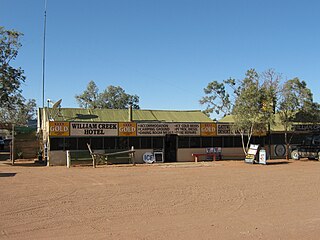
William Creek, Australia is located halfway on the Oodnadatta Track, 210 km (130 mi) north west of Marree and 166 km (103 mi) east of Coober Pedy in South Australia. The town has a permanent population of 10. William Creek is in the federal Division of Grey and the state electorate of Stuart. It is outside of council areas, and administered by the Outback Communities Authority.

Wattle Range Council is a local government area in the Limestone Coast region of South Australia. It stretches from the coast at Beachport east to the Victorian border. It had a population of over 11,000 as at the 2016 Census.
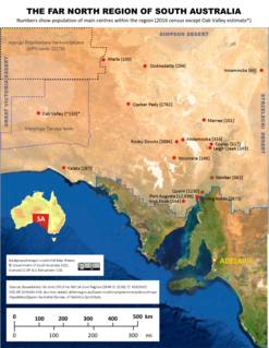
The Far North is a large region of South Australia close to the Northern Territory border. Colloquial usage of the term in South Australia refers to that part of South Australia north of a line roughly from Ceduna through Port Augusta to Broken Hill. The South Australian Government defines the Far North region similarly with the exception of the Maralinga Tjarutja Lands. the Yalata Aboriginal community and other unincorporated crown lands in the state's far west, which are officially considered part of the Eyre and Western region.
Glendambo is a town and locality in the Australian state of South Australia located on the Stuart Highway about 592 kilometres (368 mi) from the state capital of Adelaide and about 254 kilometres (158 mi) from Coober Pedy.

Bland Shire is a local government area in the Riverina region of New South Wales, Australia. it covers an area of 8,560 square kilometres (3,310 sq mi). As at the 2016 census the population was 5,995. It is a member of the League of Extraordinary Communities which was established by Dull, Perth and Kinross, Scotland and Boring, Oregon, USA.
Central Darling Shire is a local government area in the Far West region of New South Wales, Australia. The Shire is located adjacent to the Barrier Highway. Central Darling Shire was constituted in 1959 and at 53,511 square kilometres (20,661 sq mi), it is the largest incorporated local government area in New South Wales.
Opal Dream is a 2006 Australian drama film, based on the 2000 Ben Rice novella Pobby and Dingan, directed by Peter Cattaneo and starring an ensemble cast including Vince Colosimo, Jacqueline McKenzie, Christian Byers and Sapphire Boyce. It was filmed on location around South Australia, in Adelaide, Coober Pedy and Woomera. Opal Dream was released in Australia on 28 September 2006, with eventual release around the world.

Coober Pedy Airport serves the opal mining town of Coober Pedy in outback South Australia. It is located south-west of the township. The airfield, which was renamed to Redstone Airport in-game, was featured in the 2016 racing video game Forza Horizon 3 on the Xbox One and is often used for drag races.

The Kangaroo Island Council is a local government area in South Australia that covers the entirety of Kangaroo Island, 13 km off the coast of the mainland. The council was formed on the 28 November 1996 by the amalgamation of the District Council of Kingscote and the District Council of Dudley. Its first meeting held on 11 December 1996.
Mintabie is an opal mining community in the Anangu Pitjantjatjara Yankunytjatjara in South Australia. It was unique in comparison to other communities situated in the APY Lands, in that its residents were largely not of Aboriginal Australian origin, and the land had been leased to the Government of South Australia for opal mining purposes since the 1980s.
The Kanku-Breakaways Conservation Park is a protected area in northern South Australia, just off the Stuart Highway 33 km (21 mi) north of Coober Pedy. The Breakaways CP is managed under a co-management agreement by the Department of Environment, Water, and Natural Resources in conjunction with the Antakirinja Matu-Yankunytjatjara Aboriginal Corporation and the District Council of Coober Pedy.

The Tirari–Sturt stony desert is a deserts and xeric shrublands ecoregion in central Australia.
Mount Willoughby is a locality in the Australian state of South Australia located about 837 kilometres north-west of the capital city of Adelaide and about 84 kilometres north-west of the town of Coober Pedy.
Elsie "Ma" May Jenkins was an opal and mica miner who worked at Lightning Ridge and Coober Pedy in South Australia and Alice Springs in the Northern Territory of Australia. She is best known as the "Opal Queen" referencing her impressive opal collection.
Manguri Siding is located in the Adelaide–Darwin rail corridor at the locality of Mount Clarence Station, about 42 kilometres (26 mi) west of the opal mining town of Coober Pedy.
Mount Clarence Station is a locality in the Australian state of South Australia located about 771 kilometres (479 mi) north-west of the state capital of Adelaide and about 37 kilometres (23 mi) west of the town of Coober Pedy.
