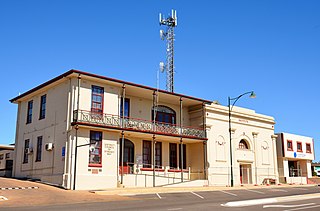
Port Lincoln is a town on the Lower Eyre Peninsula in the Australian state of South Australia. It is situated on the shore of Boston Bay, which opens eastward into Spencer Gulf. It is the largest city in the West Coast region, and is located approximately 280 km as the crow flies from the State's capital city of Adelaide. In June 2019 Port Lincoln had an estimated population of 16,418, having grown at an average annual rate of 0.55% year-on-year over the preceding five years. The city is reputed to have the most millionaires per capita in Australia, as well as claiming to be Australia's "Seafood Capital".

The Eyre Peninsula is a triangular peninsula in South Australia. It is bounded by the Spencer Gulf on the east, the Great Australian Bight on the west, and the Gawler Ranges to the north.

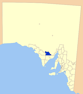
The City of Port Lincoln is a local government area located on the southern tip of the Eyre Peninsula in South Australia. It consists of one suburb - Port Lincoln. It is surrounded on land by the District Council of Lower Eyre Peninsula, which also has offices in Port Lincoln.

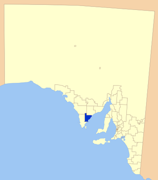
The District Council of Lower Eyre Peninsula is a local government area located on Eyre Peninsula in South Australia. The district covers the southern tip of the peninsula, except for the small area taken up by the City of Port Lincoln.

Kimba is a rural service town on the Eyre Highway at the top of Eyre Peninsula in the Australian state of South Australia. At the 2016 census, Kimba had a population of 629 and it has an annual rainfall of 348 millimetres (13.7 in). There is an 8-metre (26 ft) tall statue of a galah beside the highway, marking halfway between the east and west coasts of Australia. The Gawler Ranges are north of the highway near the town.

The District Council of Cleve is a local government area on the eastern Eyre Peninsula in South Australia. The district is mostly agricultural in nature, but also encompasses the popular coastal tourist town of Arno Bay.

Buckleboo is a locality in the Australian state of South Australia on the Eyre Peninsula located about 313 kilometres (194 mi) northwest of the state capital of Adelaide and about 31 kilometres (19 mi) northwest of the municipal seat of Kimba.

The District Council of Franklin Harbour is a local government area in South Australia on the Eyre Peninsula. Cowell is the major population centre of an agricultural district based on farming wheat and sheep, supplemented by a fishing and oyster farming industries. The district's coastal towns including Cowell and Lucky Bay attract large numbers of tourists during school holidays, with the new Spencer Gulf ferry service increasing traffic to these areas since 2006.
The District Council of Streaky Bay is a local government area in South Australia located on the Eyre Peninsula. Streaky Bay is the main population centre of about 1,200 people serving an agricultural district based on farming wheat and other cereal crops, sheep, supplemented by fishing and tourism industries. The district covers an area of 6,251.1 square kilometres with a population of 2,074 people in 2016, according to the Australian Bureau of Statistics. Mayor of Streaky Bay is Travis Barber.

The District Council of Ceduna is a local government area located on the far west coast of the Eyre Peninsula in South Australia. The district has a diverse business and industry with an estimated 240,000 tourists passing through every year. The township of Ceduna is the focal point of the district.
The Tumby Bay District Council is a local government area of South Australia covering an area of the North Eastern Eyre Peninsula. It was established in 1906, only six years after the town of Tumby Bay was established, when the district was severed from the former District Council of Lincoln to form the present council.

Wudinna District Council is a rural local government area on central Eyre Peninsula, South Australia. Its seat is Wudinna, on the Eyre Highway, 580 kilometres (360 mi) west of Adelaide. The district's economy is largely driven by agriculture, mainly cereal crops, with beef and sheep commonly farmed as well.
Ungarra is a small swamp town located on the Eyre Peninsula, in the Australian state of South Australia about 248 kilometres (154 mi) from the state's capital, Adelaide and around 80 kilometres (50 mi) north of Port Lincoln. At the 2006 census, Ungarra had a population of 241.
Rudall is a town and locality in South Australia. At the 2016 census, Rudall had a population of 90. It is named for the cadastral Hundred of Rudall, which was named after politician Samuel Rudall.
Pinkawillinie is a locality in the north of Eyre Peninsula in South Australia. It is a rural grain and grazing area in marginal country near Goyder's Line within the District Council of Kimba. It draws its name from the cadastral Hundred bearing the same name which is mostly included in the modern bounded locality, however the locality includes several other Hundreds and the Pinkawillinie Conservation Park, all within the Kimba region.

Lake Gilles is a locality in the Australian state of South Australia located on the Eyre Peninsula about 278 kilometres north west of the state capital of Adelaide and about 35 kilometres to the north-east of the town of Kimba.
County of Buxton is a cadastral unit located in the Australian state of South Australia that covers land located in the centre of Eyre Peninsula. It was proclaimed in 1896 and named after Thomas Buxton who was the Governor of South Australia from 29 October 1895 to 29 March 1899. It has been divided into thirteen sub-divisions known as hundreds, with the most recent being created in 1928.
Kelly is a locality in the Australian state of South Australia located on the Eyre Peninsula about 270 kilometres (170 mi) north-west of the state capital of Adelaide and about 13 kilometres (8.1 mi) south-east of the municipal seat in Kimba.
Moseley is a locality in the Australian state of South Australia located on the Eyre Peninsula about 286 kilometres (178 mi) north-west of the state capital of Adelaide and about 14 kilometres (8.7 mi) north-east of the municipal seat in Kimba.
Barna is a locality in the Australian state of South Australia located on the Eyre Peninsula about 266 kilometres (165 mi) north-west of the state capital of Adelaide and about 23 kilometres (14 mi) east of the municipal seat in Kimba.