Mount Remarkable National Park is a protected area in the Australian state of South Australia located about 238 kilometres (148 mi) north of the state capital of Adelaide and 25 kilometres (16 mi) east of Port Augusta. It is also the name of the highest peak in the park, with a height of 960 metres (3,150 ft).

The Flinders Ranges Council is a local government area (LGA) located in the Flinders Ranges of South Australia.
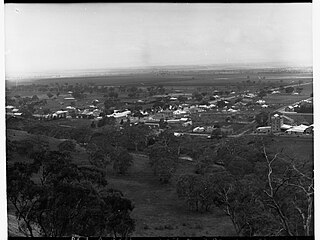
Melrose is the oldest town in the Flinders Ranges, South Australia. The town was once named "Mount Remarkable".
Laura is a rural town in the Mid North region of South Australia, 12 km north of Gladstone on the Horrocks Highway and 40 km east of Port Pirie. The first European to explore the district was Thomas Burr in September 1842. His promising reports soon led to occupation of the district by pastoralists, one of whom was Herbert Bristow Hughes. When the present town was surveyed he named it for his wife, Laura née White.

The District Council of Yankalilla is a local government area centred on the town of Yankalilla on the Fleurieu Peninsula in South Australia.

Port Germein is a small sea-side town in the Australian state of South Australia located about 219 kilometres (136 mi) north of the state capital of Adelaide and about 19 kilometres (12 mi) north of the city of Port Pirie on the eastern side of South Australia's Spencer Gulf overlooking Germein Bay. Port Germein was named after Samuel Germein, who moved into the territory in 1840, although some credit his brother John to be the first European to traverse the area. The township was proclaimed in 1878. Port Germein's population in the 2006 census was 249.
Booleroo Centre is a town in the southern Flinders Ranges region of South Australia. The town is located in the Mount Remarkable District Council local government area, 282 kilometres (175 mi) north of the state capital, Adelaide. At the 2006 census, Booleroo Centre had a population of 516.

Wilmington is a town and locality in the Yorke and Mid North region of South Australia.The town is located in the District Council of Mount Remarkable local government area, 305 kilometres (190 mi) north of the state capital, Adelaide.
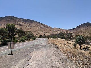
Horrocks Pass is a geographical location in the Australian state of South Australia in the localities of Nectar Brook and Woolundunga in the southern Flinders Ranges, about 6 kilometres (3.7 mi) west of the town of Wilmington. Horrocks Pass Road travels through the pass from Wilmington to the Augusta Highway in the west. It was discovered by and named after John Horrocks who travelled through the area with his party in August 1846 during his ill-fated exploration of land north of Spencer Gulf. At the top of the pass is a lookout and monument to Horrocks and his party which was erected by the District Councils of Wilmington and Port Germein and dedicated on 21 September 1946.
The Willochra Plain is a wide plain situated east of Port Augusta, South Australia. The area falls in the view from Mount Brown Lookout and from walking trails in The Dutchmans Stern Conservation Park.
The District Council of Woolundunga was a local government area in South Australia from 1888 until 1933.
The District Council of Port Germein was a local government area in South Australia, centred on the town of Port Germein. It was gazetted on 5 January 1888 under the provisions of the District Councils Act 1887 and encompassed the hundreds of Baroota, Wongyarra, Booleroo, Telowie, Darling and Appila. It replaced an abortive earlier municipality, the Corporate Town of Port Germein, which had been established on 15 September 1887 when residents, concerned about increased taxation and their interests being lost in a broader shire under the forthcoming reforms, decided to incorporate the town. The local residents reportedly regretted the decision, and when the Act passed late in the year creating the new District Council, state parliament agreed to amalgamate the Corporate Town into the new municipality.
The District Council of Wilmington was a local government area in South Australia, centred on the town of Wilmington from 1888 to 1980.
Murray Town is a locality in the Mid North of South Australia east of the lower Flinders Ranges. It was settled in 1883 and served as a rest stop for bullock and horse teams carting grain towards Port Germein from further north and east.
The Hundred of Booleroo is a cadastral hundred of the County of Frome in South Australia, centred on the eponymous township of Booleroo Centre. It was proclaimed by Governor Anthony Musgrave in 1875 and named for an indigenous term bulyeroo or bulyaroo, thought to mean "plenty" or "soft mud and clay".
The District Councils Act 1887 was an act of the Parliament of South Australia. It received assent on 9 December 1887, and its provisions came into effect when proclaimed by Governor William C. F. Robinson on 5 January 1888.
The District Council of Crystal Brook was a local government area in South Australia from 1882 until 1988, seated at Crystal Brook.
Germein Bay is a locality in the Australian state of South Australia about 205 kilometres north of the state capital of Adelaide and about 6 kilometres (3.7 mi) northeast of the city of Port Pirie.

The Hundred of Gregory is a cadastral hundred of the County of Frome in South Australia. It was proclaimed by Governor Richard MacDonnell in 1858 and named for the explorer, Augustus Charles Gregory.
The County of Frome is one of the 49 cadastral counties of South Australia in straddling the Mid North and Flinders Ranges regions. It was proclaimed in 1851 by Governor Henry Young and was named for the former Surveyor-General of South Australia, Edward Charles Frome. The iconic Mount Remarkable in the Hundred of Gregory is at the centre of the county.

