Weeroona Island, South Australia

Last updated

Weeroona Island
South Australia
Australia South Australia location map.svg
Red pog.svg
Weeroona Island
Coordinates 33°06′07″S138°01′52″E / 33.101930°S 138.031060°E / -33.101930; 138.031060 Coordinates: 33°06′07″S138°01′52″E / 33.101930°S 138.031060°E / -33.101930; 138.031060
Population 225 (shared with other localities in the State Suburb of Port Flinders) (2011 census) [1]
Established 1997 [2]
Postcode(s) 5495 [3]
Time zone ACST (UTC+9:30)
 • Summer (DST) ACST (UTC+10:30)
Location
LGA(s) District Council of Mount Remarkable [4]
State electorate(s) Stuart [5]
Federal Division(s) Grey [6]
Mean max tempMean min tempAnnual rainfall
22.7 °C
73 °F
9.3 °C
49 °F
473.3 mm
18.6 in
Suburbs around Weeroona Island:
Germein Bay (body of water)Germein BayGermein Bay
Germein Bay (body of water)Weeroona Island Germein Bay
Germein Bay (body of water)Germein BayGermein Bay
Footnotes Coordinates [4]
Locations [3]
Climate [7]
Adjoining localities [4]

Weeroona Island (formerly known as Port Flinders) is a locality in the Australian state of South Australia about 209 kilometres (130 miles) north of the state capital of Adelaide and about 9.5 kilometres (5.9 mi) northeast of the city of Port Pirie. [3] [4]

South Australia State of Australia

South Australia is a state in the southern central part of Australia. It covers some of the most arid parts of the country. With a total land area of 983,482 square kilometres (379,725 sq mi), it is the fourth-largest of Australia's states and territories by area, and fifth largest by population. It has a total of 1.7 million people, and its population is the second most highly centralised in Australia, after Western Australia, with more than 77 percent of South Australians living in the capital, Adelaide, or its environs. Other population centres in the state are relatively small; Mount Gambier, the second largest centre, has a population of 28,684.

Adelaide city centre Suburb of Adelaide, South Australia

Adelaide city centre is the innermost locality of Greater Adelaide, the capital city of South Australia. It is known by locals simply as "The City" or "Town" to distinguish it from Greater Adelaide and from the City of Adelaide. The locality is split into two key geographical distinctions: the city "square mile", bordered by North, East, South and West Terraces; and the section of the parklands south of the River Torrens which separates the built up part of the city from the surrounding suburbs and North Adelaide.

Weeroona Island began as a private subdivision of land in the Hundreds of Pirie and Telowie. The subdivision was originally named “Port Flinders” by its proponents, the Trustees of the Mount Remarkable Mining Company, in about 1853. The name was subsequently replaced by other names including Price Nob, Benjamin Hill and Weeroona Island, and was officially reinstated by the Geographical Names Advisory Committee in 1993. Boundaries were created for the locality in March 1997 and included the Weeroona Island Shack Site. The locality’s name was changed to Weeroona Island in November 2013 following a display of “strong support from residents”. The name “Weeroona Island” is derived from the name of a holiday camp operated by the Broken Hill Proprietary Company on the coastline of a bay (now known as Weeroona Bay) located near Point Lowly on the eastern coast of Eyre Peninsula. [2] [4] [8]

Subdivision (land) divided piece of land

Subdivision is the act of dividing land into pieces that are easier to sell or otherwise develop, usually via a plat. The former single piece as a whole is then known in the United States as a subdivision. If it is used for housing it is typically known as a housing subdivision or housing development, although some developers tend to call these areas communities.

The Hundred of Pirie is a cadastral unit of hundred located in the Mid North of South Australia in the approach to the lower Flinders Ranges. It is one of the hundreds of the County of Victoria. The principal township of the hundred is Port Pirie.

Point Lowly Suburb of City of Whyalla, South Australia

Point Lowly is the tip of a small peninsula north north-east of Whyalla in the Upper Spencer Gulf region of South Australia. The wider peninsula is shared by a combination of defence, industrial, residential, recreational and tourism interests. Port Bonython lies immediately to the north-west and is marked for future industrial expansion, driven by anticipated growth in the State's mining industry. The icons of the peninsula are the historic Point Lowly Lighthouse and the mass breeding aggregation of Giant Australian Cuttlefish which occurs inshore each winter.

The locality consists of an outcrop of land which is surrounded by low lying land that can be subject to inundation at high tide and which is connected to the Augusta Highway in the east by a causeway. [4] [9]

Outcrop visible exposure of bedrock or ancient superficial deposits on the surface of the Earth

An outcrop or rocky outcrop is a visible exposure of bedrock or ancient superficial deposits on the surface of the Earth.

Augusta Highway road in South Australia, Australia

The Augusta Highway is the part of Australia's ring route located in South Australia between Port Wakefield and Port Augusta. It was named Augusta Highway in 2011, and was formerly known simply as Highway One and also as the Princes Highway, despite not being continuous to the Princes Highway in the southeast of the state.

Causeway Route raised up on an embankment

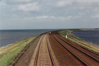
A causeway is a track, road or railway on top of an embankment across "a low, or wet place, or piece of water". It can be constructed of earth, masonry, wood, or concrete. One of the earliest known wooden causeways is the Sweet Track in the Somerset Levels, England, that dates from the Neolithic age. Timber causeways may also be described as both boardwalks and bridges.

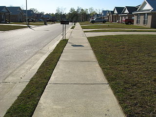
Land use within the locality consists of residential use and conservation. The former use consists of both permanent residence and ‘recreational housing’ located on the high ground while latter use is concerned with the low-lying land where built development is required to be minimal and limited to “low-intensity recreational uses” and where provided, should complement the environment of the locality. [9]

Residential area land use in which housing predominates, as opposed to industrial and commercial areas

A residential area is a land used in which housing predominates, as opposed to industrial and commercial areas. Housing may vary significantly between, and through, residential areas. These include single-family housing, multi-family residential, or mobile homes. Zoning for residential use may permit some services or work opportunities or may totally exclude business and industry. It may permit high density land use or only permit low density uses. Residential zoning usually includes a smaller FAR than business, commercial or industrial/manufacturing zoning. The area may be large or small.

Conservation (ethic) ethic of resource use, allocation, and protection

Conservation is an ethic of resource use, allocation, and protection. Its primary focus is upon maintaining the health of the natural world, its fisheries, habitats, and biological diversity. Secondary focus is on material conservation, including non-renewable resources such as metals, minerals and fossil fuels, and energy conservation, which is important to protect the natural world. Those who follow the conservation ethic and, especially, those who advocate or work toward conservation goals are termed conservationists.

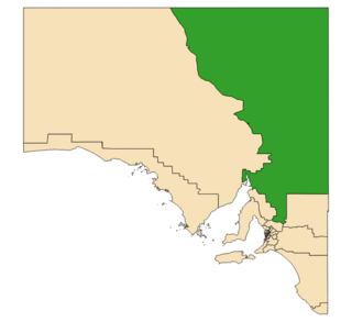
Weeroona Island is located within the federal division of Grey, the state electoral district of Stuart and the local government area of the District Council of Mount Remarkable. [6] [4] [5]

Division of Grey Australian federal electoral division

The Division of Grey is an Australian electoral division in South Australia. The division was one of the seven established when the former Division of South Australia was redistributed on 2 October 1903 and is named for Sir George Grey, who was Governor of South Australia from 1841 to 1845.

Electoral district of Stuart state electoral district of South Australia

Stuart is a single-member electoral district for the South Australian House of Assembly. At 330,656 km², it covers the northeast part of the state extending from just north of the Barossa Valley all the way to the Northern Territory, Queensland and New South Wales borders. The seat's main population centre is Port Augusta, however the seat spans from Kapunda, 80 km north of Adelaide, up to the state borders, and includes the agricultural areas of Orroroo, Peterborough, Jamestown, Burra and Leigh Creek. Stuart is the second-largest electorate by area in South Australia.

District Council of Mount Remarkable Local government area in South Australia

The Mount Remarkable District Council is a local government area located between the top of the Spencer Gulf and the base of the Southern Flinders Ranges in South Australia. The district encompasses a wide variety of towns, including coastal ports and agricultural centres. The economy of the district council is largely based on agriculture.

Related Research Articles

Port Germein, South Australia Town in South Australia

Port Germein is a small sea-side town in the Australian state of South Australia located about 219 kilometres (136 mi) north of the state capital of Adelaide and about 19 kilometres (12 mi) north of the city of Port Pirie on the eastern side of South Australia's Spencer Gulf overlooking Germein Bay. Port Germein was named after Samuel Germein, who discovered it in 1840. though some credit his brother John with the discovery. The township was proclaimed in 1878. Port Germein's population in the 2006 census was 249.

Mambray Creek, South Australia Suburb of District Council of Mount Remarkable, South Australia

Mambray Creek is a locality in the Australian state of South Australia located on the east coast of Spencer Gulf about 240 kilometres (150 mi) north of the state capital of Adelaide and about 40 kilometres (25 mi) north of the city of Port Pirie.

Karatta, South Australia Suburb of Kangaroo Island Council, South Australia

Karatta is a locality in the Australian state of South Australia located on the south coast of Kangaroo Island overlooking the body of water known in Australia as the Southern Ocean and by international authorities as the Great Australian Bight. Karatta is located about 191 kilometres south-west of the state capital of Adelaide.

Wandearah West, South Australia Suburb of Port Pirie Regional Council , South Australia

Wandearah West is a locality in the Australian state of South Australia located on the east coast of Spencer Gulf about 179 kilometres north-west of the Adelaide city centre and about 22 kilometres south of Port Pirie.

Germein Bay, South Australia Suburb of Port Pirie Regional Council, District Council of Mount Remarkable, South Australia

Germein Bay is a locality in the Australian state of South Australia about 205 kilometres north of the state capital of Adelaide and about 6 kilometres (3.7 mi) northeast of the city of Port Pirie.

Germein Bay bay in South Australia

Germein Bay is a bay in the Australian state of South Australia located at the northern end Spencer Gulf on the gulf’s east coast to the immediate north of the city of Port Pirie. Its extent includes the port known as ‘Port Pirie’ and the former port of Port Germein. Since 2012, the majority of the bay has been within the protected area known as the Upper Spencer Gulf Marine Park.

Port Davis, South Australia Suburb of Port Pirie Regional Council, South Australia

Port Davis is a locality in the Australian state of South Australia on the east coast of Spencer Gulf about 18 kilometres to the west of the city of Port Pirie and about 197 kilometres north of the state capital of Adelaide.

Lower Broughton, South Australia Suburb of Port Pirie Regional Council, South Australia

Lower Broughton is a locality in the Australian state of South Australia on the east coast of Spencer Gulf about 17 kilometres to the south of the city of Port Pirie and about 186 kilometres north of Adelaide city centre.

Baroota, South Australia Suburb of District Council of Mount Remarkable, South Australia

Baroota is a locality in the Australian state of South Australia located on the east coast of Spencer Gulf about 230 kilometres north of the state capital of Adelaide and about 29 kilometres (18 mi) north-east of the city of Port Pirie.

Lake Plains, South Australia Suburb of Alexandrina Council, South Australia

Lake Plains is a locality in the Australian state of South Australia located about 64 kilometres south of the Adelaide city centre and 27 kilometres northeast of the centre of Goolwa on the west coastline of Lake Alexandrina.

Butler, South Australia Suburb of District Council of Tumby Bay, South Australia

Butler is a locality in the Australian state of South Australia located on the Eyre Peninsula about 241 kilometres west of the state capital of Adelaide and about 31 kilometres north of the local government seat of Tumby Bay.

Newland, South Australia Suburb of Kangaroo Island Council, South Australia

Newland is a locality in the Australian state of South Australia located on Kangaroo Island about 168 kilometres south-west of the state capital of Adelaide and about 50 kilometres south-west of the municipal seat of Kingscote.

Napperby, South Australia Suburb of Port Pirie Regional Council, South Australia

Napperby is a locality in the Mid North of South Australia in the approach to the lower Flinders Ranges and is near Mount Remarkable National Park and the town of Crystal Brook.

Saltia, South Australia Town in South Australia

Saltia is a locality in the Australian state of South Australia located on the western side of the Flinders Ranges about 279 kilometres (173 mi) north of the state capital of Adelaide and about 19 kilometres (12 mi) east of the city of Port Augusta.

Kellidie Bay, South Australia Suburb of District Council of Lower Eyre Peninsula, South Australia

Kellidie Bay is a locality in the Australian state of South Australia located on the Eyre Peninsula in the state’s west overlooking parts of the body of water known as Coffin Bay about 290 kilometres (180 mi) west of the state capital of Adelaide and about 42 kilometres (26 mi) south-west of the municipal seat of Cummins.

Woolundunga, South Australia Suburb of Port Augusta , South Australia

Woolundunga is a locality in the Australian state of South Australia located on the western side of the Flinders Ranges about 271 kilometres (168 mi) north of the state capital of Adelaide and about 21 kilometres (13 mi) south-east of the city of Port Augusta.

Moockra, South Australia Suburb of Flinders Ranges , South Australia

Moockra is a locality in the Australian state of South Australia located on the eastern side of the Flinders Ranges about 274 kilometres (170 mi) north of the state capital of Adelaide and about 47 kilometres (29 mi) north-east and 36 kilometres (22 mi) south-east respectively of the municipal seats of Melrose and Quorn.

Duck Ponds, South Australia Suburb of District Council of Lower Eyre Peninsula, South Australia

Duck Ponds is a locality in the Australian state of South Australia located on the Eyre Peninsula in the state’s west about 258 kilometres (160 mi) west of the state capital of Adelaide, about 51 kilometres (32 mi) south of the municipal seat of Cummins and about 6 kilometres (3.7 mi) west of the city of Port Lincoln.

Brooker, South Australia Suburb of District Council of Tumby Bay, South Australia

Brooker is a locality in the Australian state of South Australia located in the state’s west on Eyre Peninsula about 266 kilometres (165 mi) west of the state capital of Adelaide and about 38 kilometres (24 mi) north-west of the municipal seat in Tumby Bay.

References

  1. Australian Bureau of Statistics (31 October 2012). "Port Flinders". 2011 Census QuickStats. Retrieved 26 May 2016. Blue pencil.svg
  2. 1 2 "Search result for "Port Flinders (Locality Bounded)" (Record no SA0039300) with the following layers selected - "Suburbs and Localities"". Property Location Browser. Government of South Australia. Retrieved 26 May 2016.
  3. 1 2 3 "Postcode for Port Flinders (sic)". postcodes-australia.com. Retrieved 26 May 2016.
  4. 1 2 3 4 5 6 7 "Search result for "Weeroona Island (Locality Bounded)" (Record noSA0067991) with the following layers selected - "Suburbs and Localities", "Place names (gazetteer)" and "Road Labels"". Property Location Browser. Government of South Australia. Retrieved 26 May 2016.
  5. 1 2 "District of Stuart Background Profile". ELECTORAL COMMISSION SA. Retrieved 20 August 2015.
  6. 1 2 "Federal electoral division of Grey" (PDF). Australian Electoral Commission. Retrieved 24 July 2015.
  7. "Monthly climate statistics: Summary statistics Georgetown (nearest station)". Commonwealth of Australia , Bureau of Meteorology. Retrieved 25 May 2016.
  8. "Notice of intent to alter the rural locality name of Port Flinders to Weeroona Island". Government of South Australia. Retrieved 26 May 2016.
  9. 1 2 "Development Plan, Mount Remarkable Council, Consolidated – 5 September 2013" (PDF). Government of South Australia. pp. 106–108, 144–146, & 209–213. Retrieved 26 May 2016.