Saltia, South Australia

Last updated

Saltia
South Australia
Pichi Richi Railway - panoramio (1).jpg
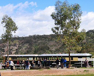
Pichi Richi Railway carriages stopped at Saltia before entering the Pichi Richi Pass
Australia South Australia location map.svg
Red pog.svg
Saltia
Coordinates 32°28′27″S137°55′57″E / 32.474202°S 137.932426°E / -32.474202; 137.932426 Coordinates: 32°28′27″S137°55′57″E / 32.474202°S 137.932426°E / -32.474202; 137.932426 [1]
Population10 (2016 census) [2]
Established1862 (sub-division)
13 December 1984 (place)
17 February 1994 (locality) [1] [3] [4]
Postcode(s) 5433 [1]
Elevation183 m (600 ft)(railway station) [5]
Time zone ACST (UTC+9:30)
 • Summer (DST) ACST (UTC+10:30)
Location
LGA(s)
Region Far North [1]
Yorke and Mid North [1]
County Frome [1]
State electorate(s) Giles [6]
Stuart [7]
Federal Division(s) Grey [8]
Mean max temp [9] Mean min temp [9] Annual rainfall [9]
24.7 °C
76 °F
13.6 °C
56 °F
257.0 mm
10.1 in
Localities around Saltia:
Emeroo Emeroo Quorn
Mundallio
Stirling North
Saltia Wilmington
Stirling North Woolundunga Woolundunga
FootnotesLocations [1]
Adjoining localities [1]

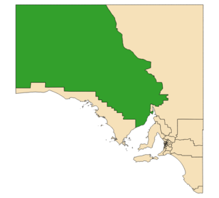
Saltia is a locality in the Australian state of South Australia located on the western side of the Flinders Ranges about 279 kilometres (173 mi) north of the state capital of Adelaide and about 19 kilometres (12 mi) east of the city of Port Augusta. [1]

South Australia State of Australia

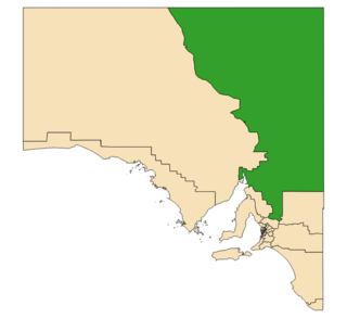
South Australia is a state in the southern central part of Australia. It covers some of the most arid parts of the country. With a total land area of 983,482 square kilometres (379,725 sq mi), it is the fourth-largest of Australia's states and territories by area, and fifth largest by population. It has a total of 1.7 million people, and its population is the second most highly centralised in Australia, after Western Australia, with more than 77 percent of South Australians living in the capital, Adelaide, or its environs. Other population centres in the state are relatively small; Mount Gambier, the second largest centre, has a population of less than 30,000.

Flinders Ranges mountain range in South Australia

The Flinders Ranges are the largest mountain range in South Australia, which starts about 200 km (125 mi) north of Adelaide. The discontinuous ranges stretch for over 430 km (265 mi) from Port Pirie to Lake Callabonna.

Adelaide city centre Suburb of Adelaide, South Australia

Adelaide city centre is the innermost locality of Greater Adelaide, the capital city of South Australia. It is known by locals simply as "The City" or "Town" to distinguish it from Greater Adelaide and from the City of Adelaide. The locality is split into two key geographical distinctions: the city "square mile", bordered by North, East, South and West Terraces; and the section of the parklands south of the River Torrens which separates the built up part of the city from the surrounding suburbs and North Adelaide.

Saltia began as a private sub-division associated with Sections 901 and 902 of the cadastral unit of the Hundred of Woolundunga in 1862. [1] The developer was Charles Simmons who purchased the land prior to 1859 followed by the erection of a hotel in the same year and the layout of the "town" in 1862. The name is derived from an Aboriginal word thaltja meaning "the gums" and spelt as thaltia in 1855. A post office was opened around 1869. [10] [1] It was declared as a place name on 13 December 1984. [3] Boundaries for the part of the locality within the City of Port Augusta in the west were proclaimed on 17 February 1994 while the part within the District Council of Mount Remarkable in the south-east was added on 13 March 1997. [4] [11]

Subdivision (land) divided piece of land

Subdivision is the act of dividing land into pieces that are easier to sell or otherwise develop, usually via a plat. The former single piece as a whole is then known in the United States as a subdivision. If it is used for housing it is typically known as a housing subdivision or housing development, although some developers tend to call these areas communities.

Hundred of Woolundunga Cadastral in South Australia

The Hundred of Woolundunga is a cadastral unit of hundred in South Australia spanning Mount Brown Conservation Park and including the localities of Woolundunga and Saltia. It is one of the 14 hundreds of the County of Frome close to the northeast coast of Spencer Gulf.

The road known as Flinders Ranges Way and the Pichi Richi Railway both pass through the locality in a west-east direction from Port Augusta towards Quorn. [1]

Flinders Ranges Way road in South Australia, Australia

The Flinders Ranges Way is the main road route through the Flinders Ranges in South Australia. It starts from the Augusta Highway at Stirling North, 6 km southeast of Port Augusta. The Flinders Ranges Way extends 209 km to Blinman. Route B83 follows the Flinders Ranges Way through Quorn to Hawker, but then branches onto the Barndioota Road along the western side of the ranges through Leigh Creek to Lyndhurst.

Pichi Richi Railway

The Pichi Richi Railway Preservation Society (PRRPS) is a non-profit railway preservation society and operating museum formed in 1973. The society, managed and staffed by volunteer members, operates heritage steam and diesel trains on the restored 39 kilometre section of track between Quorn and Port Augusta in South Australia.

Quorn, South Australia Town in South Australia

Quorn is a township and railhead in the Flinders Ranges in the north of South Australia, 39 km northeast of Port Augusta. At the 2016 census, the locality had a population of 1,230 of which 1,131 lived in its town centre.

At the 2016 census, Saltia had a population of 10 people. [2]

Saltia is located within the federal division of Grey, the state electoral districts of Giles and Stuart and the local government areas of the City of Port Augusta, the District Council of Mount Remarkable and the Flinders Ranges Council. [8] [6] [7] [1]

Division of Grey Australian federal electoral division

The Division of Grey is an Australian electoral division in South Australia. The division was one of the seven established when the former Division of South Australia was redistributed on 2 October 1903 and is named for Sir George Grey, who was Governor of South Australia from 1841 to 1845.

Electoral district of Giles state electoral district of South Australia

Giles is a single-member electoral district for the South Australian House of Assembly. Named after explorer Ernest Giles, it is the largest electorate in the state by area, covering 497,005 km2 (191,895 sq mi) of South Australian outback. Its main population centre is the industrial city of Whyalla on the far south-east border of the seat which represents half of the electorate's voters. The electorate covers significant areas of pastoral leases and Pitjantjatjara Aboriginal land stretching to the Western Australian and Northern Territory borders, taking in the remote towns of Andamooka, Coober Pedy, Ernabella, Fregon, Marla, Mimili, Mintabie, Oodnadatta, and Tarcoola. Giles also has a far north mobile booth.

Electoral district of Stuart state electoral district of South Australia

Stuart is a single-member electoral district for the South Australian House of Assembly. At 330,656 km², it covers the northeast part of the state extending from just north of the Barossa Valley all the way to the Northern Territory, Queensland and New South Wales borders. The seat's main population centre is Port Augusta, however the seat spans from Kapunda, 80 km north of Adelaide, up to the state borders, and includes the agricultural areas of Orroroo, Peterborough, Jamestown, Burra and Leigh Creek. Stuart is the second-largest electorate by area in South Australia.

Related Research Articles

Marla, South Australia Town in South Australia

Marla is a town and locality in the Australian state of South Australia located in the state's north-west about 1,100 kilometres (680 mi) north-west of the state capital of Adelaide and about 402 kilometres (250 mi) south of the town of Alice Springs in the Northern Territory.

Poochera, South Australia Town in South Australia

Poochera is a small grain belt town 60 km north-west of Streaky Bay on the Eyre Peninsula, South Australia.

Wirrulla, South Australia Town in South Australia

Wirrulla is a small grain belt town located 60 km from Streaky Bay on the Eyre Peninsula. The town is a focus point for many of the surrounding agricultural districts, and features a number of silos used to store grain from the surrounding areas. The name of the town is derived from an aboriginal word meaning "to make haste, to be quick".

Mambray Creek, South Australia Suburb of District Council of Mount Remarkable, South Australia

Mambray Creek is a locality in the Australian state of South Australia located on the east coast of Spencer Gulf about 240 kilometres (150 mi) north of the state capital of Adelaide and about 40 kilometres (25 mi) north of the city of Port Pirie.

Wanilla, South Australia Suburb of District Council of Lower Eyre Peninsula, South Australia


Wanilla is a locality in the Australian state of South Australia located on the southern end of Eyre Peninsula about 271 kilometres (168 mi) west of the state capital of Adelaide and about 25 kilometres (16 mi) north-west of the city of Port Lincoln.

Mortana, South Australia Suburb of District Council of Streaky Bay, South Australia

Mortana is a rural locality in South Australia, located on the Eyre Peninsula. It is traversed by the Flinders Highway. The boundaries for the locality were established in April 2001 in respect of the long established local name.

Lincoln National Park, South Australia Suburb of District Council of Lower Eyre Peninsula, South Australia

Lincoln National Park is a locality located on the Jussieu Peninsula at the southern tip of the Eyre Peninsula in the Australian state of South Australia about 250 kilometres west of the state capital of Adelaide and about 13 kilometres south of the city of Port Lincoln.

Tulka, South Australia Suburb of District Council of Lower Eyre Peninsula, South Australia

Tulka is a locality in the Australian state of South Australia located on the southern tip of Eyre Peninsula overlooking the western end of the body of water known as Port Lincoln and which is located 259 kilometres west of the state capital of Adelaide and about 10 kilometres west of the city of Port Lincoln.

Emeroo, South Australia Suburb of Pastoral Unincorporated Area, South Australia

Emeroo is a locality in the Australian state of South Australia about 295 kilometres north of the state capital Adelaide and about 18 kilometres northeast of Port Augusta in the state’s Far North region.

Baroota, South Australia Suburb of District Council of Mount Remarkable, South Australia

Baroota is a locality in the Australian state of South Australia located on the east coast of Spencer Gulf about 230 kilometres north of the state capital of Adelaide and about 29 kilometres (18 mi) north-east of the city of Port Pirie.

Yadlamalka, South Australia South Australia

Yadlamalka is a rural locality in the Far North region of South Australia. Yadlamalka lies at the southern tip of Lake Torrens within the Pastoral Unincorporated Area, 60 kilometres north of Port Augusta.

Mount Arden Suburb of City of Port Augusta, South Australia

Mount Arden is a locality in South Australia located on the Stuart Highway (A87) to Darwin, north of Port Augusta. and the Post Code is 5713.

Uley, South Australia Suburb of District Council of Lower Eyre Peninsula , South Australia

Uley is a locality in the Australian state of South Australia located at the southern tip of the Eyre Peninsula overlooking the body of water known as the Great Australian Bight about 273 kilometres (170 mi) west of the state capital of Adelaide and about 22 kilometres (14 mi) west of the city of Port Lincoln.

Little Douglas, South Australia Suburb of District Council of Lower Eyre Peninsula, South Australia

Little Douglas is a locality in the Australian state of South Australia located on the Eyre Peninsula in the state’s west overlooking the body of water known as Coffin Bay about 293 kilometres (182 mi) west of the state capital of Adelaide and about 42 kilometres (26 mi) south-west of the municipal seat of Cummins.

Woolundunga, South Australia Suburb of Port Augusta , South Australia

Woolundunga is a locality in the Australian state of South Australia located on the western side of the Flinders Ranges about 271 kilometres (168 mi) north of the state capital of Adelaide and about 21 kilometres (13 mi) south-east of the city of Port Augusta.

Stephenston, South Australia Suburb of Flinders Ranges Council , South Australia

Stephenston is a locality in the Australian state of South Australia located on the eastern side of the Flinders Ranges about 285 kilometres (177 mi) north of the state capital of Adelaide and about 15 kilometres (9.3 mi) east of the municipal seat of Quorn.

Moockra, South Australia Suburb of Flinders Ranges , South Australia

Moockra is a locality in the Australian state of South Australia located on the eastern side of the Flinders Ranges about 274 kilometres (170 mi) north of the state capital of Adelaide and about 47 kilometres (29 mi) north-east and 36 kilometres (22 mi) south-east respectively of the municipal seats of Melrose and Quorn.

Duck Ponds, South Australia Suburb of District Council of Lower Eyre Peninsula, South Australia

Duck Ponds is a locality in the Australian state of South Australia located on the Eyre Peninsula in the state’s west about 258 kilometres (160 mi) west of the state capital of Adelaide, about 51 kilometres (32 mi) south of the municipal seat of Cummins and about 6 kilometres (3.7 mi) west of the city of Port Lincoln.

Brooker, South Australia Suburb of District Council of Tumby Bay, South Australia

Brooker is a locality in the Australian state of South Australia located in the state’s west on Eyre Peninsula about 266 kilometres (165 mi) west of the state capital of Adelaide and about 38 kilometres (24 mi) north-west of the municipal seat in Tumby Bay.

References

  1. 1 2 3 4 5 6 7 8 9 10 11 12 13 14 15 16 "Search results for 'Saltia, LOCB' with the following datasets being selected - 'Suburbs and Localities', 'Postcodes', 'Counties', 'Hundreds', 'Local Government Areas', 'SA Government Regions', 'Land Development Plan Zone Categories', 'Railway' and 'Gazetteer'". Location SA Map Viewer. Government of South Australia. Retrieved 3 January 2019.
  2. 1 2 Australian Bureau of Statistics (27 June 2017). "State Suburb of Saltia". 2016 Census QuickStats. Retrieved 1 February 2018. Blue pencil.svg
  3. 1 2 "GEOGRAPHICAL NAMES ACT 1969-1982, Notice of Declaration of Names of Places" (PDF). The South Australian Government Gazette. South Australian Government. 13 December 1984. p. 1835. Retrieved 1 February 2018.
  4. 1 2 "GEOGRAPHICAL NAMES ACT 1991, Notice to Assign" (PDF). The South Australian Government Gazette. South Australian Government. 17 February 1994. p. 482. Retrieved 1 February 2018.
  5. "Search result for 'Saltia Railway Station' with the following datasets selected - 'Suburbs and Localities' and 'Gazetteer'". Location SA Map Viewer. South Australian Government. Retrieved 1 February 2018.
  6. 1 2 "District of Giles Background Profile". Electoral Commission SA. Retrieved 14 May 2016.
  7. 1 2 "District of Stuart Background Profile". Electoral Commission SA. Retrieved 20 August 2015.
  8. 1 2 "Federal electoral division of Grey" (PDF). Australian Electoral Commission. Retrieved 24 July 2015.
  9. 1 2 3 "Monthly climate statistics: Summary statistics Port Augusta Power Station (nearest station)". Commonwealth of Australia , Bureau of Meteorology. Retrieved 1 February 2018.
  10. Manning, Geoffrey. "South Australian Names - S" (PDF). Manning Index of South Australian History. State Library of South Australia. Retrieved 1 February 2018.
  11. "GEOGRAPHICAL NAMES ACT 1991 Notice to Assign Names and Boundaries to Places" (PDF). The South Australian Government Gazette. South Australian Government. 13 March 1997. p. 1177. Retrieved 1 February 2018.