Quorn is a small town and railhead in the Flinders Ranges in the north of South Australia, 39 kilometres (24 mi) northeast of Port Augusta. At the 2016 census, the locality had a population of 1,230, of which 1,131 lived in its town centre.
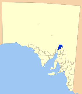
Flinders Ranges Council is a local government area (LGA) located in the Flinders Ranges of South Australia.
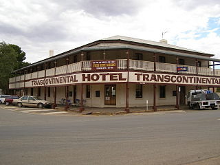
Glendambo is a town and locality in the Australian state of South Australia located on the Stuart Highway about 592 kilometres (368 mi) from the state capital of Adelaide and about 254 kilometres (158 mi) from Coober Pedy.

Parachilna is a country town in South Australia. The town was first surveyed in 1863 due to its closeness to a government water well. It is on the railway line and road between Port Augusta and Leigh Creek. Today, the Prairie Hotel, railway station, airstrip and a few buildings remain. The road east into the Flinders Ranges leads through Parachilna Gorge, recognised for its scenic beauty, to Blinman. The town is surrounded by Motpena station pastoral lease.

Mambray Creek is a locality in the Australian state of South Australia located on the east coast of Spencer Gulf about 240 kilometres (150 mi) north of the state capital of Adelaide and about 40 kilometres (25 mi) north of the city of Port Pirie.

Olary is a town and locality on the Barrier Highway in South Australia. It is situated near Olary Creek and is one of the easternmost settlements in South Australia. The name "Olary" was first given to a nearby well or waterhole by pastoralists Duffield, Harrold and Hurd.
Blanche Harbor is a locality in South Australia located on the east coast of the Eyre Peninsula overlooking Spencer Gulf about 260 kilometres north north-west of the Adelaide city centre and about 20 kilometres south of the centre of Port Augusta.
Port Paterson is a locality in the Australian state of South Australia located on the east coast of Spencer Gulf at the gulf's northern end about 237.4 kilometres north of the state capital of Adelaide and about 9 kilometres south of the centre of Port Augusta.
Emeroo is a locality in the Australian state of South Australia about 295 kilometres north of the state capital of Adelaide and about 18 kilometres northeast of Port Augusta in the state’s Far North region.
Germein Bay is a locality in the Australian state of South Australia about 205 kilometres north of the state capital of Adelaide and about 6 kilometres (3.7 mi) northeast of the city of Port Pirie.
Weeroona Island is a locality in the Australian state of South Australia about 209 kilometres north of the state capital of Adelaide and about 9.5 kilometres (5.9 mi) northeast of the city of Port Pirie.
Baroota is a locality in the Australian state of South Australia located on the east coast of Spencer Gulf about 230 kilometres north of the state capital of Adelaide and about 29 kilometres (18 mi) north-east of the city of Port Pirie.

Flinders Ranges is a locality in the Australian state of South Australia located in the mountain range of the same name, about 380 kilometres north of the state capital of Adelaide, about 86 kilometres north-east of the municipal seat of Quorn and about 131 kilometres north-east of the centre of Port Augusta in the state’s Far North region.
Mount Willoughby is a locality in the Australian state of South Australia located about 837 kilometres north-west of the capital city of Adelaide and about 84 kilometres north-west of the town of Coober Pedy.

Saltia is a locality in the Australian state of South Australia located on the western side of the Flinders Ranges about 279 kilometres (173 mi) north of the state capital of Adelaide and about 19 kilometres (12 mi) east of the city of Port Augusta.
Woolundunga is a locality in the Australian state of South Australia located on the western side of the Flinders Ranges about 271 kilometres (168 mi) north of the state capital of Adelaide and about 21 kilometres (13 mi) south-east of the city of Port Augusta.

Stephenston is a locality in the Australian state of South Australia located on the eastern side of the Flinders Ranges about 285 kilometres (177 mi) north of the state capital of Adelaide and about 15 kilometres (9.3 mi) east of the municipal seat of Quorn.
Moockra is a locality in the Australian state of South Australia located on the eastern side of the Flinders Ranges about 274 kilometres (170 mi) north of the state capital of Adelaide and about 47 kilometres (29 mi) north-east and 36 kilometres (22 mi) south-east respectively of the municipal seats of Melrose and Quorn.
Barna is a locality in the Australian state of South Australia located on the Eyre Peninsula about 266 kilometres (165 mi) north-west of the state capital of Adelaide and about 23 kilometres (14 mi) east of the municipal seat in Kimba.
Mount Clarence Station is a locality in the Australian state of South Australia located about 771 kilometres (479 mi) north-west of the state capital of Adelaide and about 37 kilometres (23 mi) west of the town of Coober Pedy.
