Yarrah, South Australia

Last updated

Yarrah
South Australia
Australia South Australia location map.svg
Red pog.svg
Yarrah
Coordinates 32°11′50″S137°52′28″E / 32.197336°S 137.874510°E / -32.197336; 137.874510 Coordinates: 32°11′50″S137°52′28″E / 32.197336°S 137.874510°E / -32.197336; 137.874510 [1]
Postcode(s) 5433 [1]
Location 17 km (11 mi) north-west of Quorn
LGA(s) Flinders Ranges Council
Pastoral unincorporated area [1]
Region Far North [1]
County Newcastle [1]
State electorate(s) Giles [1]
Federal Division(s) Grey [1]
Localities around Yarrah:
Wilkatana Station Yadlamalka Wallerberdina
Barndioota
Mount Arden Yarrah Kanyaka
Willochra
Emeroo Emeroo
Quorn
Quorn
Footnotes Adjoining localities [1]

Yarrah is a rural locality in the Far North region of South Australia. The eastern section of Yarrah lies within the Flinders Ranges Council, while the western section lies in the pastoral unincorporated area. [1]

Suburbs and localities are the names of geographic subdivisions in Australia, used mainly for address purposes. The term locality is used in rural areas, while the term suburb is used in urban areas. Australian postcodes closely align with the boundaries of localities and suburbs.

Far North (South Australia) Region in South Australia

The Far North is a large region of South Australia close to the Northern Territory border. Colloquial usage of the term in South Australia refers to that part of South Australia north of a line roughly from Ceduna through Port Augusta to Broken Hill. The South Australian Government defines the Far North region similarly with the exception of the Maralinga Tjarutja Lands. the Yalata Aboriginal Reserve and other unincorporated crown lands in the state's far west, which are officially considered part of the Eyre and Western region.

South Australia State of Australia

South Australia is a state in the southern central part of Australia. It covers some of the most arid parts of the country. With a total land area of 983,482 square kilometres (379,725 sq mi), it is the fourth-largest of Australia's states and territories by area, and fifth largest by population. It has a total of 1.7 million people, and its population is the second most highly centralised in Australia, after Western Australia, with more than 77 percent of South Australians living in the capital, Adelaide, or its environs. Other population centres in the state are relatively small; Mount Gambier, the second largest centre, has a population of less than 30,000.

History

The traditional owners of the area are the Barngarla people. [2] The name 'Yarrah' is said to come from an Aboriginal word meaning "river red gum". [3]

Barngarla people Australian Aboriginal ethnic group of the Port Lincoln, Whyalla and Port Augusta areas of South Australia

The Barngarla, formerly known as Parnkalla, are an Aboriginal people of the Port Lincoln, Whyalla and Port Augusta areas. The Barngarla are the traditional owners of much of Eyre Peninsula, South Australia, Australia.

A township at Yarrah, located along the railway line, was surveyed in April 1863 and offered for sale on 21 July 1864 [4] but was largely unsuccessful. [5] The hundred of Yarrah was proclaimed on 16 December 1880 by Governor William Jervois. [3] It was in the County of Newcastle.

A hundred is an administrative division that is geographically part of a larger region. It was formerly used in England, Wales, some parts of the United States, Denmark, Southern Schleswig, Sweden, Finland, Estonia, and Norway. It is still used in other places, including South Australia, and The Northern Territory.

William Jervois British Army general

Lieutenant General Sir William Francis Drummond Jervois was a British military engineer and diplomat. After joining the British Army in 1839, he saw service, as a second captain, in South Africa. In 1858, as a major, he was appointed Secretary of a Royal Commission set up to examine the state and efficiency of British land-based fortifications against naval attack; and this led to further work in Canada and South Australia. From 1875 to 1888 he was, consecutively, Governor of the Straits Settlements, Governor of South Australia and Governor-General of New Zealand.

County of Newcastle Cadastral in South Australia

The County of Newcastle is one of the 49 counties of South Australia spanning the central Flinders Ranges. It was named in 1876 for Francis Pelham-Clinton-Hope, the eighth Duke of Newcastle.

Yarrah Post Office opened on 1 October 1887 and closed around 1909. [6] Yarrah Primary School opened in 1893. In about 1919, [7] it closed because of small attendance, but then re-opened in 1919, only to be closed permanently at a later date. [8] [9]

‘The little galvanised-iron church at Yarraville [sic]’ is mentioned in the Register newspaper. [10]

Wilkatana railway station was located in the west of the hundred of Yarrah, named after nearby Wilkatana Station. [11] The Depot Creek railway station, further to the south within the hundred of Yarrah, existed for many years; however, Pacific National advised in 2013 that the station had been closed, although the line continues to be in use. [12] The historic Depot Creek Weir is located at Yarrah, and is listed on the South Australian Heritage Register. The weir dates from 1912 to 1917, when it was built as part of the supply infrastructure for the Port Augusta-Kalgoorlie section of the Trans-Australian Railway; the underlying springs had earlier been used by explorer Edward John Eyre. [13] [1]

Wilkatana Station rural locality in the Far North region of South Australia

Wilkatana Station is a sheep and cattle station in the Australian state of South Australia located north of the regional city of Port Augusta and south of Lake Torrens. It covers an area of 458 square kilometres (177 sq mi) which is located within the gazetted localities of Wilkatana Station in the west and Yarrah in the east.

Pacific National Australian rail transport company

Pacific National is one of Australia's largest rail freight businesses. Formed in February 2002 as a joint venture between Patrick Corporation and Toll Holdings, which formed the holding company Asciano Limited. It is now a subsidiary of Australian Logistics Acquisition Holdings Pty Limited, via Australian Logistics Acquisition Investments Pty Limited and Asciano Limited.

The South Australian Heritage Register is a statutory register of historic places in South Australia. It extends legal protection regarding demolition and development under the Heritage Places Act 1993. It is administered by the South Australian Heritage Council. As a result of the progressive abolition of the Register of the National Estate during the 2000s and the devolution of responsibility for state-significant heritage to state governments, it is now the primary statutory protection for state-level heritage in South Australia.

The gazetted locality of Yarrah was created in November 1999. The locality's boundaries roughly equate to those of the hundred of Yarrah and approximately half of the adjacent hundred of Wyacca. In April 2013, an additional portion of formerly unincorporated land was added to the locality.

In 2013, Australia Post altered the local postcode from 5713 to 5433 as part of a review of outback postcodes. [14] [1]

Much of the 1950 film Bitter Springs , starring Chips Rafferty, was filmed at Yarrah. [15]

Related Research Articles

Cummins, South Australia Town in South Australia

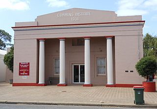
Cummins is a town on Eyre Peninsula in South Australia, 67 km north of Port Lincoln and 68 m above sea level. At the 2011 census, the town had a population of 719.

Buckleboo Town in South Australia

Buckleboo is a locality in the Australian state of South Australia on the Eyre Peninsula located about 313 kilometres (194 mi) northwest of the state capital of Adelaide and about 31 kilometres (19 mi) northwest of the municipal seat of Kimba.

Taplan, South Australia Town in South Australia

Taplan is a town in the Murray Mallee region of South Australia near the border with Victoria. Taplan is an aboriginal word meaning grass tree. The town was laid out by Henry George in 1914. The railway from Adelaide to Paringa was laid past the site of the future township in 1913, 183.25 miles (294.91 km) by rail from Adelaide. The Taplan Post Office was open from 1 July 1914 to 14 May 1982.

Parachilna, South Australia Town in South Australia

Parachilna is a country town in South Australia. The town was first surveyed in 1863 due to its closeness to a government water well. It is on the railway line and road between Port Augusta and Leigh Creek. Today, the Prairie Hotel, railway station, airstrip and a few buildings remain. The road east into the Flinders Ranges leads through Parachilna Gorge, recognised for its scenic beauty, to Blinman. The town is surrounded by Motpena station pastoral lease.

Kalangadoo, South Australia Town in South Australia

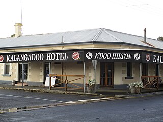
Kalangadoo is a locality in the Australian state of South Australia located about 348 kilometres (216 mi) south-east of the state capital of Adelaide and about 31 kilometres (19 mi) north of the regional centre of Mount Gambier.

Coorabie Town in South Australia

Coorabie is a town and locality in the Australian state of South Australia located located about 675 kilometres (419 mi) north-west of the state capital of Adelaide. It is outside of district council boundaries, and therefore managed by the Outback Communities Authority. It is located in the west of South Australia, and includes the Wahgunyah Conservation Park. The Eyre Highway passes through the locality, although the Coorabie township is south of the highway.

Wanilla, South Australia Suburb of District Council of Lower Eyre Peninsula, South Australia


Wanilla is a locality in the Australian state of South Australia located on the southern end of Eyre Peninsula about 271 kilometres (168 mi) west of the state capital of Adelaide and about 25 kilometres (16 mi) north-west of the city of Port Lincoln.

Peebinga, South Australia Town in South Australia

Peebinga is a town and locality in the Australian state of South Australia. Peebinga was the terminus of the Peebinga railway line which was built in 1914 as part of a major state government project to open up the Murray Mallee for grazing and cropping.

Mantung, South Australia Town in South Australia

Mantung is a town and a locality in the Australian state of South Australia located in the state's south-east about 140 kilometres (87 mi) east of the state capital of Adelaide, and about 58 kilometres (36 mi) north-east and about 48 kilometres (30 mi) south-west respectively of the municipal seats of Karoonda and Loxton.

Hammond, South Australia Town in South Australia

Hammond is a town and locality in the Australian state of South Australia located in the southern Flinders Ranges.

Kanyaka, South Australia Town in South Australia

Kanyaka is a rural locality in the Far North region of South Australia, situated in the Flinders Ranges Council.

Pine Creek, South Australia Town in South Australia

Pine Creek is a rural locality in the Mid North region of South Australia, situated in the Regional Council of Goyder. It was established in August 2000 when boundaries were formalised for the long established local name.

Brownlow, South Australia Suburb of Regional Council of Goyder, Mid Murray Council, South Australia

Brownlow is a locality in the Australian state of South Australia about 98 kilometres north-east of the Adelaide city centre

Butler, South Australia Suburb of District Council of Tumby Bay, South Australia

Butler is a locality in the Australian state of South Australia located on the Eyre Peninsula about 241 kilometres west of the state capital of Adelaide and about 31 kilometres north of the local government seat of Tumby Bay.

Colton, South Australia Suburb of District Council of Elliston , South Australia

Colton is a locality in the Australian state of South Australia located on the west coast of Eyre Peninsula overlooking the Great Australian Bight about 374 kilometres (232 mi) north-west of the state capital of Adelaide and about 19 kilometres (12 mi) north of the municipal seat of Elliston.

County of Manchester Cadastral in South Australia

County of Manchester is a cadastral unit located in the Australian state of South Australia that covers land both located in the north-east of Eyre Peninsula and to the peninsula's north. It was proclaimed in 1891 and named after George Montagu, 6th Duke of Manchester who was the father-in-law of the Rt Hon. Earl of Kintore GCMG, the Governor of South Australia at the time.

Verran, South Australia Suburb of District Council of Cleve, South Australia

Verran is a locality in the Australian state of South Australia located on the Eyre Peninsula about 241 kilometres west of the state capital of Adelaide. Its name is derived from the cadastral unit of the Hundred of Verran, which was named for former Premier John Verran.

County of Le Hunte Cadastral in South Australia

County of Le Hunte is a cadastral unit located in the Australian state of South Australia that covers land located in the centre of Eyre Peninsula. It was proclaimed in 1908 and named after George Le Hunte who was the Governor of South Australia from July 1903 to February 1909.

Moockra, South Australia Suburb of Flinders Ranges , South Australia

Moockra is a locality in the Australian state of South Australia located on the eastern side of the Flinders Ranges about 274 kilometres (170 mi) north of the state capital of Adelaide and about 47 kilometres (29 mi) north-east and 36 kilometres (22 mi) south-east respectively of the municipal seats of Melrose and Quorn.

Kringin, South Australia Suburb of District Council of Loxton Waikerie , South Australia

Kringin is a town and a locality in the Australian state of South Australia located in the state’s east about 199 kilometres (124 mi) east of the state capital of Adelaide and about 61 kilometres (38 mi) south of the municipal seat of Loxton.

References

  1. 1 2 3 4 5 6 7 8 9 10 11 "Search result for Yarrah, 5433 with the following datasets selected - 'Suburbs and Localities', "Government Towns', 'Local Government Areas', 'SA Government Regions', 'Counties', 'Hundreds' and 'Gazetteer'". Location SA Map Viewer. Government of South Australia. Retrieved 17 February 2016.
  2. This name is one of the names used on the widely used Aboriginal Australia Map, by David Horton (ed.), 1994 published in The Encyclopedia of Aboriginal Australia by AIATSIS. This map also divides Australia into 18 regions (Southwest, Northwest, Desert, Kimberley, Fitzmaurice, North, Arnhem, Gulf, West Cape, Torres Strait, East, Rainforest, Northeast, Eyre, Riverine, Southeast, Spencer and Tasmania).
  3. 1 2 "Hundred of Yarrah". Property Location Browser. Government of South Australia. Retrieved 17 February 2016.
  4. South Australian Place Names.
  5. "Wilkatana Railway Station". Property Land Browser. Government of South Australia. Retrieved 17 February 2016.
  6. "Yarrah". Post Office Reference. Premier Postal. Retrieved 17 February 2016.
  7. South Australian Place Names.
  8. "SCHOOL MATTERS". Observer (Adelaide, SA : 1905 - 1931) . Adelaide, SA: National Library of Australia. 26 January 1918. p. 28. Retrieved 17 February 2016.
  9. "Yarrah Primary School". Property Land Browser. Government of South Australia. Retrieved 17 February 2016.
  10. Register 18 October 1924, page 11g.
  11. "Wilkatana Railway Station". Property Land Browser. Government of South Australia. Retrieved 17 February 2016.
  12. "Depot Creek Railway Station". Property Land Browser. Government of South Australia. Retrieved 17 February 2016.
  13. "Depot Creek Weir". South Australian Heritage Register. Department of Environment, Water and Natural Resources. Retrieved 17 February 2016.
  14. "Yarrah". Property Land Browser. Government of South Australia. Retrieved 17 February 2016.
  15. "Bitter Springs". Property Land Browser. Government of South Australia. Retrieved 17 February 2016.