Lake Torrens is a large ephemeral, normally endorheic salt lake in central South Australia. After sufficiently extreme rainfall events, the lake flows out through the Pirie-Torrens corridor to the Spencer Gulf.

Coorabie is a town and locality in the Australian state of South Australia located about 675 kilometres (419 mi) north-west of the state capital of Adelaide. It is outside of district council boundaries, and therefore managed by the Outback Communities Authority. It is located in the west of South Australia, and includes the Wahgunyah Conservation Park. The Eyre Highway passes through the locality, although the Coorabie township is south of the highway.
Yellabinna is a locality in the Australian state of South Australia located to the north of the town of Ceduna in the western part of the state.
Danggali is a locality in the Australian state of South Australia located about 70 kilometres north of the town of Renmark and about 230 kilometres north east of the state capital of Adelaide.
Witchelina is a locality in the Australian state of South Australia located about 32 kilometres to the north-west of the town of Leigh Creek and about 487 kilometres north of the Adelaide city centre. The locality was established on 26 April 2013 in respect to “the long established local name.” Its name is derived from the former pastoral lease of the same name. Witchelina is located within the federal Division of Grey, the state electoral district of Stuart, the Pastoral Unincorporated Area of South Australia and the state's Far North region. The land use within Witchelina is concerned with the use of the former pastoral lease as a private protected area also known as Witchelina which has fully occupied its extent as of 2010.
Calperum Station is a locality in the Australian state of South Australia located on the northern side of the Murray River about 10 kilometres to the north of the town of Renmark and about 250 kilometres east of the centre of the capital city of Adelaide.
Taylorville Station is a locality in the Australian state of South Australia located about 250 kilometres north-east of the Adelaide and about 35 kilometres to the north-west of the municipal seat of Renmark.
Middleback Range is a locality in the Australian state of South Australia located in the north east corner of Eyre Peninsula to the south-west of the city of Whyalla and extending from the coastline of Spencer Gulf in the east to the west side of the southern end of the Middleback Range in the west.

Lake Eyre is a locality in the Australian state of South Australia located about 718 kilometres north of the state capital of Adelaide and 134 kilometres north of the town of Marree and which is associated with the occasional body of water known as Lake Eyre.
Gidgealpa is a locality in the Australian state of South Australia located about 780 kilometres north-east of the capital city of Adelaide and about 58 kilometres south-west of the town of Innamincka.
Simpson Desert is a locality in the Australian state of South Australia located about 920 kilometres north of the capital city of Adelaide and which is located within the desert of the same name.
Lake Harris is a locality in the Australian state of South Australia located about 530 kilometres north-west of the capital city of Adelaide and which is associated with the lake also known as Lake Harris.
Etadunna is a locality in the Australian state of South Australia located about 684 kilometres north of the capital city of Adelaide and about 108 kilometres north-east of the town of Marree.
County of Hore-Ruthven is a cadastral unit in the Australian state of South Australia that covers land both in the north of the Eyre Peninsula and to the peninsula's north. It was proclaimed in 1933 and was named after Alexander Hore-Ruthven, the Governor of South Australia from 1928 to 1934.
Pureba is a locality in the Australian state of South Australia located on the west coast of Eyre Peninsula and on land to the immediate north of the peninsula about 528 kilometres north-west of the state capital of Adelaide and about 52 kilometres north-east and 90 kilometres north respectively of the municipal seats of Ceduna and Streaky Bay.
Mount Willoughby is a locality in the Australian state of South Australia located about 837 kilometres north-west of the capital city of Adelaide and about 84 kilometres north-west of the town of Coober Pedy.
Wallerberdina is a locality in the Australian state of South Australia located about 345 kilometres (214 mi) north of the state capital of Adelaide and about 40 kilometres (25 mi) west of the town of Hawker.

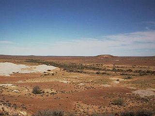
County of Blachford is a cadastral unit located in the Australian state of South Australia that covers land between the east coast of Lake Torrens and the western side of the Flinders Ranges about 90 kilometres (56 mi) north-east of the city of Port Augusta. It was proclaimed in 1877 and named after Frederic Rogers, 1st Baron Blachford who was the Under Secretary of State for the Colonies from 1860 to 1871. It has been partially divided in the following sub-units of hundreds – Barndioota, Cotabena, Warrakimbo, Wonoka and Woolyana.
Allandale Station is a locality in the Australian state of South Australia located about 848 kilometres (527 mi) north of the state capital of Adelaide and about 20 kilometres (12 mi) south-east of the town of Oodnadatta.
Mount Clarence Station is a locality in the Australian state of South Australia located about 771 kilometres (479 mi) north-west of the state capital of Adelaide and about 37 kilometres (23 mi) west of the town of Coober Pedy.
