Stephenston, South Australia

Last updated

Stephenston
South Australia

Hundred of Palmer, 1938 (23157829344).jpg

Drawing of the Hundred of Palmer, 1938, including the layout of the former Government Town of Stephenston.
Australia South Australia location map.svg
Red pog.svg
Stephenston
Coordinates 32°22′59″S138°11′58″E / 32.38306°S 138.199306°E / -32.38306; 138.199306 [1]
Population 0 (2016 census) [2]
Established 13 March 1997 [3]
Postcode(s) 5433 [4]
Time zone ACST (UTC+9:30)
 • Summer (DST) ACST (UTC+10:30)
Location
LGA(s) Flinders Ranges Council [1]
Region Far North [1]
County Newcastle [1]
State electorate(s) Giles [5]
Federal Division(s) Grey [6]
Mean max temp [7] Mean min temp [7] Annual rainfall [8]
24.7 °C
76 °F
13.6 °C
56 °F
269.7 mm
10.6 in
Suburbs around Stephenston:
Quorn Willochra Moockra
Quorn Stephenston Moockra
Quorn Bruce
Hammond
Moockra
Footnotes Location [1] [4]
Adjoining localities [1]

Stephenston is a locality in the Australian state of South Australia located on the eastern side of the Flinders Ranges about 285 kilometres (177 mi) north of the state capital of Adelaide and about 15 kilometres (9.3 mi) east of the municipal seat of Quorn. [1] [4]

South Australia State of Australia

South Australia is a state in the southern central part of Australia. It covers some of the most arid parts of the country. With a total land area of 983,482 square kilometres (379,725 sq mi), it is the fourth-largest of Australia's states and territories by area, and fifth largest by population. It has a total of 1.7 million people, and its population is the second most highly centralised in Australia, after Western Australia, with more than 77 percent of South Australians living in the capital, Adelaide, or its environs. Other population centres in the state are relatively small; Mount Gambier, the second largest centre, has a population of less than 30,000.

Flinders Ranges mountain range in South Australia

The Flinders Ranges are the largest mountain range in South Australia, which starts about 200 km (125 mi) north of Adelaide. The discontinuous ranges stretch for over 430 km (265 mi) from Port Pirie to Lake Callabonna.

Adelaide city centre Suburb of Adelaide, South Australia

Adelaide city centre is the innermost locality of Greater Adelaide, the capital city of South Australia. It is known by locals simply as "The City" or "Town" to distinguish it from Greater Adelaide and from the City of Adelaide. The locality is split into two key geographical distinctions: the city "square mile", bordered by North, East, South and West Terraces; and the section of the parklands south of the River Torrens which separates the built up part of the city from the surrounding suburbs and North Adelaide.

Boundaries for the locality were created in March 1997 for the “long established name“ which was “incorrectly spelt as Stephenson” in the South Australian Government Gazette of 13 March 1997 and is derived from the ceased Government Town of Stephenston whose site is located within the boundaries of the locality. [1] [3] [9]

The South Australian Government Gazette is the government gazette of the South Australian Government. First printed on 20 June 1839, the South Australian Government chose to have its own publication rather than using the local newspaper, South Australian Gazette and Colonial Register because the publishers were perceived as politically biased. The purpose was to publish government orders and acts with authority of the colonial secretary. Initially it was called South Australian Gazette.

The Government Town of Stephenston which was located in the cadastral unit of the Hundred of Palmer was surveyed in February 1879, proclaimed on 17 July 1879 and was finally declared as ‘ceasing to exist’ on 11 May 1961. A school operated from 1881 to 1915 and a post office operated from November 1879 to 1904. [10] [11] [12]

The Hundred of Palmer is a cadastral hundred of the County of Newcastle in South Australia. It is located near 32.195°S, 138.215°E east of the township of Quorn, and south of the former town of Willochra which, although surveyed in 1860, never properly developed and was abandoned during the drought in the 1860s.

Land use within the locality is concerned with primary production activities such as “pastoral and farming-related activities.” [13]

The 2016 Australian census which was conducted in August 2016 reports that Stephenston had a population of zero. [2]

The 2016 Australian census was the seventeenth national population census held in Australia. The census was officially conducted with effect on Tuesday, 9 August 2016. The total population of the Commonwealth of Australia was counted as 23,401,892 – an increase of 8.8 per cent or 1,894,175 people since the 2011 census. Norfolk Island joined the census for the first time in 2016, adding 1,748 to the population.

Stephenston is located within the federal division of Grey, the state electoral district of Giles and the local government area of the Flinders Ranges Council. [6] [5] [1]

Division of Grey Australian federal electoral division

The Division of Grey is an Australian electoral division in South Australia. The division was one of the seven established when the former Division of South Australia was redistributed on 2 October 1903 and is named for Sir George Grey, who was Governor of South Australia from 1841 to 1845.

Electoral district of Giles state electoral district of South Australia

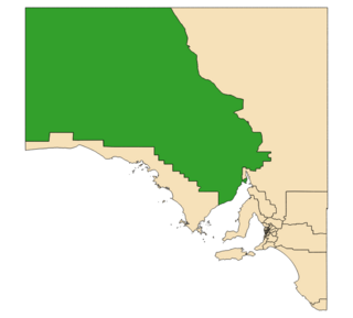
Giles is a single-member electoral district for the South Australian House of Assembly. Named after explorer Ernest Giles, it is the largest electorate in the state by area, covering 497,005 km2 (191,895 sq mi) of South Australian outback. Its main population centre is the industrial city of Whyalla on the far south-east border of the seat which represents half of the electorate's voters. The electorate covers significant areas of pastoral leases and Pitjantjatjara Aboriginal land stretching to the Western Australian and Northern Territory borders, taking in the remote towns of Andamooka, Coober Pedy, Ernabella, Fregon, Marla, Mimili, Mintabie, Oodnadatta, and Tarcoola. Giles also has a far north mobile booth.

Flinders Ranges Council Local government area in South Australia

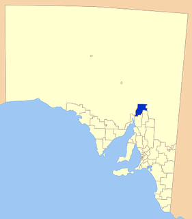
Flinders Ranges Council is a local government area (LGA) located in the Flinders Ranges of South Australia.

Related Research Articles

Tantanoola, South Australia Town in South Australia

Tantanoola is a town in regional South Australia. The name is derived from the aboriginal word tentunola, which means boxwood / brushwood hill or camp. Tantanoola was originally named 'Lucieton' by Governor Jervois after his daughter Lucy Caroline, on 10 July 1879. It was changed by Governor Robinson to 'Tantanoola' on 4 October 1888. At the 2006 census, Tantanoola had a population of 255.

Wirrulla, South Australia Town in South Australia

Wirrulla is a small grain belt town located 60 km from Streaky Bay on the Eyre Peninsula. The town is a focus point for many of the surrounding agricultural districts, and features a number of silos used to store grain from the surrounding areas. The name of the town is derived from an aboriginal word meaning "to make haste, to be quick".

Eurelia Town in South Australia

Eurelia is a town and locality in the Australian state of South Australia located on the east side of the Flinders Ranges about 264 kilometres (164 mi) north of the state capital of Adelaide and about 20 kilometres (12 mi) from the municipal seat of Orroroo.

Hynam, South Australia Town in South Australia

Hynam is a town and locality in the Australian state of South Australia located in the state's south-east within the Limestone Coast region on the border with the state of Victoria about 302 kilometres south east of the state capital of Adelaide and about 11 kilometres east of the municipal seat of Naracoorte.

Mambray Creek, South Australia Suburb of District Council of Mount Remarkable, South Australia

Mambray Creek is a locality in the Australian state of South Australia located on the east coast of Spencer Gulf about 240 kilometres (150 mi) north of the state capital of Adelaide and about 40 kilometres (25 mi) north of the city of Port Pirie.

Nangwarry, South Australia Town in South Australia

Nangwarry is a town and a locality in the Australian state of South Australia located about 352 kilometres (219 mi) south-east of the state capital of Adelaide and about 32 kilometres (20 mi) north-west of the regional centre of Mount Gambier.

Wanilla, South Australia Suburb of District Council of Lower Eyre Peninsula, South Australia


Wanilla is a locality in the Australian state of South Australia located on the southern end of Eyre Peninsula about 271 kilometres (168 mi) west of the state capital of Adelaide and about 25 kilometres (16 mi) north-west of the city of Port Lincoln.

Calca, South Australia Town in South Australia

Calca is a small township around 20 kilometres (12 mi) south-east of Streaky Bay, on the southern border of the Calpatanna Waterhole Conservation Park, Eyre Peninsula.

Tooligie, South Australia Town in South Australia

Tooligie is a small town in South Australia on the Eyre Peninsula about 290 kilometres west of the Adelaide city centre and about 84 kilometres north of the city of Port Lincoln.

Hincks, South Australia Suburb of District Council of Cleve, District Council of Tumby Bay, South Australia

Hincks is a locality in the Australian state of South Australia located on the Eyre Peninsula about 253 kilometres west of the state capital of Adelaide.

Pureba, South Australia Suburb of District Council of Ceduna, South Australia

Pureba is a locality in the Australian state of South Australia located on the west coast of Eyre Peninsula and on land to the immediate north of the peninsula about 528 kilometres north-west of the state capital of Adelaide and about 52 kilometres north-east and 90 kilometres north respectively of the municipal seats of Ceduna and Streaky Bay.

Midgee, South Australia Suburb of District Council of Franklin Harbour, South Australia

Midgee is a locality in the Australian state of South Australia located on the east coast of Eyre Peninsula about 214 kilometres north-west of the state capital of Adelaide and about 37 kilometres north of the municipal seat of Cowell.

Saltia, South Australia Town in South Australia

Saltia is a locality in the Australian state of South Australia located on the western side of the Flinders Ranges about 279 kilometres (173 mi) north of the state capital of Adelaide and about 19 kilometres (12 mi) east of the city of Port Augusta.

Yalpara, South Australia Suburb of District Council of Orroroo Carrieton , South Australia

Yalpara is a locality in the Australian state of South Australia located about 265 kilometres (165 mi) north of the state capital of Adelaide and about 29 kilometres (18 mi) north-east of the municipal seat in Orroroo.

Amyton, South Australia Suburb of Mount Remarkable , South Australia

Amyton is a locality in the Australian state of South Australia located on the eastern side of the Flinders Ranges about 259 kilometres (161 mi) north of the state capital of Adelaide and about 28 kilometres (17 mi) north-east of the municipal seat of Melrose.

Moockra, South Australia Suburb of Flinders Ranges , South Australia

Moockra is a locality in the Australian state of South Australia located on the eastern side of the Flinders Ranges about 274 kilometres (170 mi) north of the state capital of Adelaide and about 47 kilometres (29 mi) north-east and 36 kilometres (22 mi) south-east respectively of the municipal seats of Melrose and Quorn.

Johnburgh, South Australia Suburb of District Council of Orroroo Carrieton, South Australia

Johnburgh is a town and a locality in the Australian state of South Australia located on the eastern side of the Flinders Ranges about 275 kilometres (171 mi) north of the state capital of Adelaide and about 32 kilometres (20 mi) north-east of the municipal seat of Orroroo.

Yanyarrie, South Australia Suburb of District Council of Orroroo Carrieton, South Australia

Yanyarrie is a locality in the Australian state of South Australia located on the eastern side of the Flinders Ranges about 289 kilometres (180 mi) north of the state capital of Adelaide and about and 45 kilometres (28 mi) north of the municipal seat of Orroroo.

Duck Ponds, South Australia Suburb of District Council of Lower Eyre Peninsula, South Australia

Duck Ponds is a locality in the Australian state of South Australia located on the Eyre Peninsula in the state’s west about 258 kilometres (160 mi) west of the state capital of Adelaide, about 51 kilometres (32 mi) south of the municipal seat of Cummins and about 6 kilometres (3.7 mi) west of the city of Port Lincoln.

Brooker, South Australia Suburb of District Council of Tumby Bay, South Australia

Brooker is a locality in the Australian state of South Australia located in the state’s west on Eyre Peninsula about 266 kilometres (165 mi) west of the state capital of Adelaide and about 38 kilometres (24 mi) north-west of the municipal seat in Tumby Bay.

References

  1. 1 2 3 4 5 6 7 8 9 "Search results for 'Stephenston, LOCB' with the following datasets being selected - 'Suburbs and Localities', 'Postcode', 'Counties', 'Hundreds', 'Local Government Areas', 'SA Government Regions', 'Land Development Plan Zone Categories' and 'Gazetteer'". Location SA Map Viewer. Government of South Australia. Retrieved 15 February 2018.
  2. 1 2 Australian Bureau of Statistics (27 June 2017). "State Suburb of Stephenston". 2016 Census QuickStats. Retrieved 15 February 2018. Blue pencil.svg
  3. 1 2 "GEOGRAPHICAL NAMES ACT 1991 Notice to Assign Names and Boundaries to Places" (PDF). The South Australian Government Gazette. South Australian Government. 13 March 1997. p. 1177. Retrieved 15 February 2018.
  4. 1 2 3 "Postcode for Stephenston, South Australia". Postcodes Australia. Retrieved 15 February 2018.
  5. 1 2 "District of Giles Background Profile". Electoral Commission SA. Retrieved 12 February 2018.
  6. 1 2 "Federal electoral division of Grey" (PDF). Australian Electoral Commission. Retrieved 12 February 2018.
  7. 1 2 "Monthly climate statistics: Summary statistics Port Augusta Power Station (nearest station)". Commonwealth of Australia , Bureau of Meteorology. Retrieved 1 February 2018.
  8. "Monthly rainfall: Summary statistics for all years - Bruce (nearest station)". Commonwealth of Australia , Bureau of Meteorology. Retrieved 15 February 2018.
  9. "GEOGRAPHICAL NAMES ACT 1991 Notice to Assign Names and Boundaries to Places (in the Flinders Ranges Council)" (PDF). The South Australian Government Gazette. South Australian Government. 25 November 1999. p. 2442. Retrieved 15 February 2018.
  10. Manning, Geoffrey H. (2012). "Search result for Stephenston" (PDF). A Compendium of the Place Names of South Australia From Aaron Creek to Zion Hill With 54 Complementary Appendices. Geoffrey Manning. Retrieved 15 February 2018.
  11. "Untitled proclamation under the Crown Lands Consolidation Act re the Town of Stephenson" (PDF). The South Australian Government Gazette. South Australian Government. 17 July 1879. p. 1090. Retrieved 15 February 2018.
  12. "CROWN LANDS ACT, 1929-1960: TOWN OF STEPHENSTON DECLARED TO CEASE TO EXIST" (PDF). The South Australian Government Gazette. South Australian Government. 11 May 1961. p. 1090. Retrieved 15 February 2018.
  13. "The Flinders Ranges Council - Consolidated – 20 June 2013" (PDF). South Australian Government. 20 June 2013. pp. 96, 139, 142 and 145. Retrieved 15 February 2018.