Murraylands

Last updated

The Murraylands region takes its name from the River Murray, which runs through it for 200 kilometres (120 miles) Map of the Murraylands region of South Australia.png
The Murraylands region takes its name from the River Murray, which runs through it for 200 kilometres (120 miles)
The South Australian Railways constructed 715 kilometres (444 miles) of lightly built railway lines to encourage agricultural development throughout the Murraylands in the 1910s Map of Murraylands railway lines (South Australian Railways) 1913.jpg
The South Australian Railways constructed 715 kilometres (444 miles) of lightly built railway lines to encourage agricultural development throughout the Murraylands in the 1910s

The Murraylands is a geographical region of the Australian state of South Australia (SA); its name reflects that of the river running through it. Lying due east of South Australia's capital city, Adelaide, it extends from the eastern slopes of the Mount Lofty Ranges to the border with the state of Victoria, a distance of about 180 kilometres (110 miles). The north-to-south distance is about 130 kilometres (81 miles). The region's economy is centred on agriculture (especially vegetables, grains and livestock), and tourism, especially along its 200-kilometre (120-mile) frontage of the River Murray. [note 1]

Contents

The main towns in the region, in order of population at the 2016 census, are: [note 2]

These towns' populations totalled 24,600. [2] People living outside the towns approximated 8,000. [note 3]

The region has a Mediterranean climate, with warm to hot, dry summers and mild winters. Mean maximum temperatures range from 22.3 °C (72 °F) in the south to 23.6 °C (74 °F) in the north; minimums are from 8.8 °C (48 °F) to 8.8 °C (48 °F) respectively. [4]

Regional context

The Murraylands region is long established in South Australia and the name is widely used by residents of the region and elsewhere in the state, but there is a multiplicity of names that refer to the geography in that part of the state. Local Government Areas and South Australian Government Regions continually change, and in the case of the Murraylands, its boundaries no longer correspond exactly with other types of divisions. The 2018 state electorate of Hammond had the nearest-equivalent borders. [5] The South Australian Government region of which it was part was Murray and Mallee, extending about 170 kilometres (110 miles) north of the Murraylands to include the Riverland region; and extending to the south of the Murraylands to The Coorong. [3] Of similar size to the Murray and Mallee region is Regional Development Australia's Murraylands and Riverland Region. [6] A generic term, applied to a larger area than the Murraylands, is Murray Mallee . Tourism regions are different again: the South Australian Tourism Commission includes the Murraylands with the lakes at the mouth of the Murray, and The Coorong, in an area that earned $148  million in 2018. [7] The area extends well into the state of Victoria, where it is known simply as The Mallee. [note 4]

Economy

Wheat farming dominates much of the Murraylands landscape Aerial view of Murraylands landscape.jpg
Wheat farming dominates much of the Murraylands landscape

The Murraylands economy is strongly reliant on primary industry. In 2014–15, primary production accounted for 41.6 per cent of the gross regional product in the SA Government's Murray and Mallee region. Within the Murraylands, the top three commodities were vegetables, grains and livestock. [11] [12] From 2001 to 2009 and 2017 to 2019, the Murraylands region was one of many regions in south-east Australia afflicted by severe drought, which significantly degraded the economy. [13] [14]

Governance

As of 2021, local government councils within the Murraylands were:

Recreation and tourism

Recreational opportunities are abundant in the region. There are many sport facilities, reserves, parks, and trails for walking, cycling and horse riding. [15] Many are connected to the River Murray. A major government program has funded a Murray Coorong Trail initiative, which will eventually connect a range of loop trails and experiences beside or near the river for 250 kilometres (160 miles) from Cadell in the Riverland to Salt Creek in the Coorong National Park; as of 2021 a 5 kilometres (3.1 miles) walking trail had been completed at Parnka Point in Coorong National Park and others were being constructed. [16]

Recreational fishing and watersports are especially popular. The Murray Bridge Rowing Club, founded in 1909, is one of South Australia's oldest rowing clubs [17] and has fostered many champions, including recent world champion and Olympic medal winner, James McRae; and Walter Pfeiffer, Walter Jarvis, Frank Cummings, Ted Thomas (rower), Herbert Graetz, William Sladden, Robert Cummings, Arthur Scott, and Alf Taeuber.

Festivals and events

As of 2021:

  • January: Asian Le Mans Series car races and other motorsport events, The Bend Motorsport Park, Tailem Bend
  • January: Murray River Splash program (family fun activities)
  • February: Murray Bridge Fringe, a three-day event
  • March: Revolve24, "fast, safe, fun-on-a-bike weekend festival of cycling, The Bend Motorpsort Park, Tailem Bend
  • September–April: Murray Bridge Speedway events
  • September: Australian International Pedal Prix, Murray Bridge
  • October: Callington Show
  • October, March: Country by the River, a two-day music festival, Murray Bridge
  • October, December: Motorsport Australia Championships, The Bend Motorsport Park, Tailem Bend
  • November: All Steamed Up – engine, blacksmith and classic boat festival, Mannum
  • Every month: Mannum Cars and Coffee, in Arnold Park, Mannum
  • Various days: Murray Bridge Racing Club events and races.

River Murray International Dark Sky Reserve

At the north-west corner of the Murraylands is the River Murray International Dark Sky Reserve, an area of 3200 square kilometres (1200 square miles) centred on the Swan Reach Conservation Park – one of the darkest locations in the world. The darkness is enhanced by the dry climate and low humidity with long periods of clear skies all year round. Low population, freedom from major development, and supportive policies of the Mid Murray Council regarding artificial light and future development were also crucial in the reserve being established. [18]

Conservation

Respect for the natural environment on which they depend is a strong characteristic of people in the area. The region has a number of national parks and conservation areas where bush walking, sightseeing, bird watching, camping, caravanning, 4-wheel driving and orienteering activities are welcome. They include: [19]

Education

As of 2021, the Murraylands region had 47 educational establishments within and immediately outside its boundaries, as shown in the table.

Educational establishments
Pre-schoolPrimarySecondary and TAFE*
Morgan Preschool**Morgan Primary School**Swan Reach Area School
Swan Reach and Area KindergartenTruro Primary SchoolMannum Community College
Mannum KindergartenBlanchetown Primary SchoolMurray Bridge High School
Murray Bridge Preschool KindergartenCambrai Area School**Unity College, Murray Bridge
Callington KindergartenSwan Reach Primary SchoolTyndale Christian School, Murray Bridge
Tailem Bend KindergartenSwan Reach Area SchoolSt Joseph's School, Murray Bridge
Meningie Kindergarten**Palmer Primary SchoolMeningie Area School**
Coonalpyn Kindergarten**Mypolonga Primary SchoolLameroo Regional Community School
Tintinara Preschool**Murray Bridge South Primary SchoolMurray Bridge TAFE
Lameroo and District KindergartenMurray Bridge North Primary School
Pinnaroo KindergartenFraser Park Primary School, Murray Bridge
Concordia KindergartenMurray Bridge State School
Callington Primary School
Tailem Bend Primary School
Meningie Area School**
Salt Creek Primary School
Coonalpyn Primary School
Coomandook Area School
Tintinara Area School**
Lameroo Regional Community School
Pinnaroo Primary School
Karoonda Area School
Mannum Community College Junior School
Tyndale Christian School, Murray Bridge
St Joseph's School, Murray Bridge
Unity College Junior School, Murray Bridge
*TAFE: Technical and further education college.  **Located just outside the formal Murraylands boundary.

Media

Notes

  1. It is customary in South Australia to use this word order when referring to the two major rivers of the state, as reflected in the naming principles issued by the Government of South Australia, which include: ... "'river' should be used as a generic term following the specific name of the feature – e.g. 'Onkaparinga River' – except when referring to the River Torrens or River Murray." [1] South Australians may also place "River" first when referring to the Darling River, the major tributary that joins the Murray in New South Wales.
  2. A few kilometres outside the boundaries are Coonalpyn in the south and Meningie in the south-west, with populations of 1118 and 313 respectively; they are not included in this article.
  3. Difference between 32,600 population of council districts [3] (adjusted for variations in settlements) and the total town populations. [2]
  4. The term mallee applies to various species of trees or woody plants, mainly of the genus Eucalyptus, which grow with multiple stems springing from an underground bulbous woody structure (a lignotuber, or mallee root), usually to a height of no more than 29 metres (630 feet). [8] The term is also applied to land where mallee eucalypts grow – generally flat without hills or tall trees and where the climate is semi-arid. [9] [10]
  5. Only the lightly populated south-eastern part of the council district is within the Murraylands.
  6. Only the northern half of the council district is within the Murraylands.

Related Research Articles

<span class="mw-page-title-main">Tailem Bend, South Australia</span> Town in South Australia

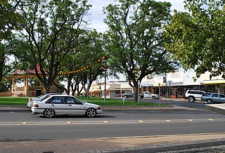
Tailem Bend is a rural town in South Australia, 85 kilometres south-east of the state capital of Adelaide. It is located on the lower reaches of the River Murray, near where the river flows into Lake Alexandrina. It is linear in layout since it is constrained by river cliffs on its western side and the Adelaide–Melbourne railway line is dominant on its eastern side. The town grew and consolidated through being a large railway centre between the 1890s and 1990s; now it continues to service regional rural communities. In the 2021 census, Tailem Bend and the surrounding area had a population of 1,705.

Agile Communications is a licensed national telecommunications carrier based in South Australia and was the first South Australian based company to gain this license. The company is the wholesale subsidiary of ISP Internode. The company was founded by Internode Managing Director Simon Hackett and Catherine Conway and is based in Adelaide. Internode and Agile were bought out by iiNet in 2012 and iiNet itself was acquired by TPG Telecom in 2015.

<span class="mw-page-title-main">Murray Bridge, South Australia</span> City in South Australia

Murray Bridge is a city in the Australian state of South Australia, located 78 kilometres (48 mi) east-southeast of the state's capital city, Adelaide, and 77 kilometres (48 mi) north of the town of Meningie.

<span class="mw-page-title-main">Mid Murray Council</span> Local government area in South Australia

The Mid Murray Council is a local government area in South Australia in the Murray and Mallee region of South Australia. The council spans the area from the Riverland through the Murraylands to the eastern slopes of the Mount Lofty Ranges. It includes 220 km of the Murray River. The council seat is at Mannum; it also maintains secondary offices at Cambrai and Morgan.

The Murray Mallee is the grain-growing and sheep-farming area of South Australia. It is bounded to the north and west by the Murray River, called the "River Murray" in South Australia, to the east by the Victorian border, and extending about 50 km south of the Mallee Highway.

<span class="mw-page-title-main">Riverland</span> Region in South Australia

The Riverland is a region of South Australia. It covers an area of 9,386 square kilometres (3,624 sq mi) along the River Murray from where it flows into South Australia from New South Wales and Victoria downstream to Blanchetown. The major town centres are Renmark, Berri, Loxton, Waikerie, Barmera and Monash, and many minor townships. The population is approximately 35,000 people.

<span class="mw-page-title-main">Loxton, South Australia</span> Town in South Australia

Loxton is a town on the south bank of the River Murray in the Riverland region of South Australia. It is located on the lands of the Erawirung people who occupied the area before the arrival of Europeans.

<span class="mw-page-title-main">Jabuk, South Australia</span> Town in South Australia

Jabuk is a locality in the Australian state of South Australia located about 142 kilometres (88 mi) south-east of the state capital of Adelaide and respectively about 78 kilometres (48 mi) west and 58 kilometres (36 mi) east of the municipal seats of Pinnaroo and Tailem Bend.

<span class="mw-page-title-main">Mallee Football League (South Australia)</span>

The Mallee Football League (MFL) was an Australian rules football competition in South Australia. The league comprised teams located in south eastern South Australia and one team (Murrayville) located in western Victoria.

The River Murray Football League is an Australian rules football competition based in the Murray Bridge region of South Australia, Australia. It is an affiliated member of the South Australian National Football League.

The Border Times, based in Pinnaroo, is the local newspaper of the Southern Mallee region of South Australia since 1911. Published weekly, it focuses on local news, sports and weather.

<span class="mw-page-title-main">Yumali, South Australia</span> Town in South Australia

Yumali is a town in South Australia 162 km southeast of Adelaide on the Dukes Highway (A8). Yumali belongs to The Coorong District Council and is in the State electorate of Hammond and the Federal electorate of Barker. Yumali is in the County of Buccleuch.

<span class="mw-page-title-main">Coorong District Council</span> Local government area in South Australia

Coorong District Council is a local government area in South Australia located between the River Murray and the Limestone Coast region. The district covers mostly rural areas with small townships, as well as part of the Coorong National Park.

The Adelaide–Wolseley railway line is a 313 kilometre line running from Adelaide to Wolseley on the Australian Rail Track Corporation network. It is the South Australian section of the Melbourne–Adelaide railway.

<span class="mw-page-title-main">Loxton railway line</span> Former railway line in South Australia

The Loxton railway line is a closed railway line in the northern Murray Mallee region of South Australia. It ran north-east from Tailem Bend to grain silos near Loxton.

The Barmera railway line was the second railway built to develop the Murray Mallee region of South Australia, in 1913. It followed the success of the Pinnaroo railway line in 1906. Both lines branched east from Tailem Bend to the north of the main Melbourne–Adelaide railway. The Brown's Well line was the more northerly, and extended into country which had not been developed much before the railway, partly due to the absence of any viable transport route for produce. The original terminus of the Brown's Well railway was at Meribah, not far from the Victorian border.

In South Australia, one of the states of Australia, there are many areas which are commonly known by regional names. Regions are areas that share similar characteristics. These characteristics may be natural such as the Murray River, the coastline, desert or mountains. Alternatively, the characteristics may be cultural, such as common land use. South Australia is divided by numerous sets of regional boundaries, based on different characteristics. In many cases boundaries defined by different agencies are coterminous.

Bowhill is a locality in South Australia. A settlement is located inside a bend on the left (eastern/southern) bank of the Murray River between Mannum and Swan Reach. It is predominantly shacks built facing the river bank. The settlement is in the Mid Murray Council area, but most of the locality is located away from the river and within in the District Council of Karoonda East Murray, including the Lowan Conservation Park.

Elwomple is a locality in The Coorong District Council in the South Australian Murray Mallee, southeast of Tailem Bend. The northwest corner is the junction of the Mallee Highway which forms the northern boundary of Elwomple, and the Dukes Highway which forms the southwestern boundary. The Bend Motorsport Park was developed in Elwomple adjacent to this junction. In September 2017, before the facility opened, the boundary between Tailem Bend and Elwomple was adjusted so that The Bend Motorsport Park was officially in Tailem Bend, not Elwomple.

References

  1. "Geographical names guidelines". Planning and property. Attorney-General's Department (Government of South Australia). August 2020. Retrieved 8 February 2021.
  2. 1 2 "Advanced search". Australian Bureau of Statistics. 2021. Retrieved 11 October 2021.
  3. 1 2 "Search result for "Karoonda, Locb" with the "SA Government Regions" dataset selected". Location SA Map viewer. Government of South Australia. Retrieved 11 October 2021.
  4. "Climate data online: map search". Bureau of Meteorology. 2021. Retrieved 11 October 2021.
  5. "Interactive map: search results for Hammond in 2018-2022 districts". Electoral Commission South Australia. 2021. Retrieved 11 October 2021.
  6. "Murraylands and Riverland South Australia". Regional Development Australia. 2021. Retrieved 11 October 2021.
  7. "South Australian visitor economy sector plan 2030" (PDF). South Australian Tourism Commission. 2019. p. 16. Retrieved 11 October 2021.
  8. "Habit". Euclid. Australian National Botanic Gardens. Archived from the original on 9 February 2020. Retrieved 6 May 2007.
  9. "Plants of the Mallee Shrublands" (PDF). Australian Government - Parks Australia. Retrieved 30 April 2020.
  10. "Mallee Woodlands and Shrublands". Australian National Botanic Gardens. Retrieved 30 April 2020.
  11. "Regional Profile Murray & Mallee 2014-15 (final)". Data SA. Government of South Australia. 17 August 2017. Retrieved 11 October 2021.
  12. "Murraylands and Riverland South Australia" (PDF). Primary Industries and Regions SA. p. 2. Retrieved 11 October 2021.
  13. "Annual Australian Climate Statement 2009". Australian Bureau of Meteorology. 5 January 2010. Retrieved 26 January 2017.
  14. "Drought". Bureau of Meteorology. 5 December 2019. Retrieved 11 October 2021.
  15. "Leisure facilities". Rural City of Murray Bridge. Retrieved 11 October 2021.
  16. "Trails and walks". Coorong District Council. July 2021. Retrieved 11 October 2021.
  17. "Murray Bridge Rowing Club History". Murray Bridge Rowing Club. Retrieved 11 October 2021.
  18. "River Murray International Dark Sky Reserve fact sheet" (PDF). The Murray River, Lakes and Coorong Tourism Alliance. 2021. Retrieved 12 October 2021.
  19. Murray River: Riverland, lakes and Coorong visitor guide. South Australia Tourism Commission. 2015. pp. 20–21.