Coorong, South Australia

Last updated

Coorong
South Australia
CSIRO ScienceImage 3803 Sand dunes in the Coorong South Australia provide habitat for many key species.jpg
View across the Coorong lagoon towards sandhills on Younghusband Peninsula
Australia South Australia location map.svg
Red pog.svg
Coorong
Coordinates 36°07′S139°36′E / 36.12°S 139.60°E / -36.12; 139.60 Coordinates: 36°07′S139°36′E / 36.12°S 139.60°E / -36.12; 139.60 [1]
Population58 (2016 census) [2]
Established1998 [1]
Postcode(s) 5264 [3]
Time zone ACST (UTC+9:30)
 • Summer (DST) ACST (UTC+10:30)
Location80 km (50 mi) SE of Adelaide [3]
LGA(s) Coorong
Kingston
(north to south) [1]
Region Murray and Mallee
Limestone Coast
(north to south) [1]
County Russell
Cardwell
MacDonnell
(north to south) [1]
State electorate(s) MacKillop [4]
Federal division(s) Barker [5]
Mean max temp [6] Mean min temp [6] Annual rainfall [6]
20.8 °C
69 °F
10.3 °C
51 °F
468.3 mm
18.4 in
Suburbs around Coorong:
See Surrounding localities
FootnotesLocation [3]

Coorong is a locality in the Australian state of South Australia which is associated with the lagoon known as the Coorong in the south-east of the state and which overlooks the continental coastline from the mouth of the Murray River about 80 kilometres (50 miles) south-east of the state capital of Adelaide to the immediate north of the town of Kingston SE extending for a distance of at least 140 kilometres (87 mi). [1] [3] [7]

It extends from the Murray Mouth in the north to the northern end of the Paranki Lagoon in the south including: [1] [8]

The boundaries of the locality were created firstly for the part within the Kingston District Council in 1998 and secondly for the part within the Coorong District Council in 2000 including the Villa De Yumpa Shack Site. The name is reported as being derived from the lagoon of the same name. [1] The boundary with the locality of Hindmarsh Island was altered in 2014 to move Bird Island, an island located north-east of the Murray Mouth, into the locality of Coorong. [9] [10]

The principal land use in Coorong is conservation with the majority of the land being occupied by the Coorong National Park and the Mud Islands Game Reserve. [11] [12]

The 2016 Australian census which was conducted in August 2016 reports that Coorong had a population of 58 people. [2]

The locality includes the following state heritage places: Magrath Flat Homestead, Teeluc Cottage and White Hut Cottage [13] [14] [15]

Coorong is located within the federal Division of Barker, the state electoral district of MacKillop and the local government areas of the Kingston District Council and the Coorong District Council. [4] [5] It is also located in the cadastral counties of Russell, Cardwell and MacDonnell (from north to south) and the South Australian Government regions of Murray and Mallee and Limestone Coast (from north to south). [1]

Surrounding localities

Coorong is bounded in the sector from the west to the south by the body of water known in Australia as the Southern Ocean and by international authorities as the Great Australian Bight and bounded from the north-west to the south-east by the following localities gazetted under the South Australian Geographical Names Act 1991: [1] [16] [17]

Related Research Articles

<span class="mw-page-title-main">Coorong National Park</span> Protected area in South Australia

Coorong National Park is a protected area located in South Australia about 156 kilometres (97 mi) south-east of Adelaide, that predominantly covers a coastal lagoon ecosystem officially known as The Coorong and the Younghusband Peninsula on the Coorong's southern side. The western end of the Coorong lagoon is at the Murray Mouth near Hindmarsh Island and the Sir Richard Peninsula, and it extends about 130 kilometres (81 mi) south-eastwards. Road access is from Meningie. The beach on the coastal side of the peninsula, the longest in Australia, is also commonly called The Coorong.

<span class="mw-page-title-main">Lake Alexandrina (South Australia)</span> Fresh water lake in South Australia

Lake Alexandrina is a coastal freshwater lake located between the Fleurieu and Kangaroo Island and Murray and Mallee regions of South Australia, about 100 kilometres (62 mi) south-east of Adelaide. The lake adjoins the smaller Lake Albert and a coastal lagoon called The Coorong to its southeast, before draining into the Great Australian Bight via a short, narrow opening known as Murray Mouth.

<span class="mw-page-title-main">Lake Albert (South Australia)</span> Lake in South Australia

Lake Albert, also known by its Ngarrindjeri name, Yarli, is a notionally fresh water lake near the mouth of the Murray River in South Australia. It is filled by water flowing in from the larger Lake Alexandrina at its mouth near Narrung. It is separated on the south by the Narrung Peninsula from the salt-water Coorong. The only major town on the lake is Meningie. Lakes Alexandrina and Albert are together known as the Lower Lakes.

<span class="mw-page-title-main">Murray Mouth</span> Body of water

Murray Mouth is the point at which the River Murray meets the Southern Ocean. The Murray Mouth's location is changeable. Historical records show that the channel out to sea moves along the sand dunes over time. At times of greater river flow and rough seas, the two bodies of water would erode the sand dunes to create a new channel leaving the old one to silt and disappear.

<span class="mw-page-title-main">Meningie, South Australia</span> Town in South Australia

Meningie is a town on the south-east side of Lake Albert in South Australia. It is on the Princes Highway near The Coorong and was surveyed in 1866. At the 2016 census, the locality of Meningie had a population of 1118 with a median age of 51 while its town centre had a population of 852.

<span class="mw-page-title-main">Younghusband Peninsula</span> Place in South Australia

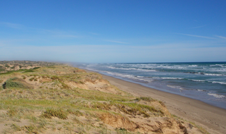
Younghusband Peninsula is a long narrow peninsula in South Australia. It separates the Coorong Channel, the Tauwitchere Channel and the Coorong which are part of the estuary of the River Murray from the Southern Ocean which including water bodies such as Encounter and Lacepede Bays. It lies entirely within the Coorong National Park. The peninsula is over 110 kilometres (68 mi) long, but less than 3 kilometres (1.9 mi) wide at its widest point. Its narrowest point is less than 350 metres (1,150 ft) wide. The Younghusband Peninsula, together with the Sir Richard Peninsula on the western side of the Murray Mouth, are the coastal dune system that forms the continental coastline from near Goolwa in the north west to about 35 kilometres north of Kingston SE in the south east. Younghusband Peninsula was named after William Younghusband, M.P.

<span class="mw-page-title-main">Coorong District Council</span> Local government area in South Australia

Coorong District Council is a local government area in South Australia located between the River Murray and the Limestone Coast region. The district cover mostly rural areas with small townships, as well as part of the Coorong National Park.

<span class="mw-page-title-main">Salt Creek, South Australia</span> Town in South Australia

Salt Creek is a small settlement in South Australia, located along the Coorong, and is also the location of the Coorong National Park Information Centre.

Mud Islands Game Reserve is a protected area in South Australia covering ten islands at the southern side of Lake Alexandrina about 19 kilometres south-east of Goolwa. The game reserve is described as providing ‘an ideal habitat for water birds, particularly waterfowl’ and that ‘duck shooting is permitted during open season.’ Since 2000, the game reserve has been located within the boundaries of the gazetted locality, Coorong.

<span class="mw-page-title-main">Flinders Chase, South Australia</span> Suburb of Kangaroo Island Council, South Australia

Flinders Chase is a locality in the Australian state of South Australia located on the south-western coast of Kangaroo Island overlooking the body of water known in Australia as the Southern Ocean and by international authorities as the Great Australian Bight. It is located about 210 kilometres south-west of the state capital of Adelaide.

<span class="mw-page-title-main">Canunda, South Australia</span> Suburb of District Council of Grant, Wattle Range Council., South Australia

Canunda is a locality in the Australian state of South Australia located on the state’s south-east coast overlooking the body of water known in Australia as the Southern Ocean and by international authorities as the Great Australian Bight. It is about 339 kilometres south-east of the state capital of Adelaide and 49 kilometres south of the centre of Mount Gambier.

<span class="mw-page-title-main">Pelican Lagoon, South Australia</span> Suburb of Kangaroo Island Council, South Australia

Pelican Lagoon is a locality in the Australian state of South Australia located on the south coast of Dudley Peninsula on Kangaroo Island overlooking the body of water known in Australia as the Southern Ocean and by international authorities as the Great Australian Bight. It is located about 123 kilometres south of the state capital of Adelaide and about 17 kilometres south-west of Penneshaw.

<span class="mw-page-title-main">MacGillivray, South Australia</span> Suburb of Kangaroo Island Council, South Australia

MacGillivray is a locality in the Australian state of South Australia located on the south coast of Kangaroo Island overlooking the body of water known in Australia as the Southern Ocean and by international authorities as the Great Australian Bight. It is located about 140 kilometres southwest of the state capital of Adelaide and about 24 kilometres south of the municipal seat of Kingscote.

<span class="mw-page-title-main">Poltalloch, South Australia</span> Suburb of Coorong District Council, South Australia

Poltalloch is a locality in the Australian state of South Australia located on land between the water bodies of Lake Alexandrina and Lake Albert about 87 kilometres south-east of the state capital of Adelaide.

Wangolina is a locality in the Australian state of South Australia located on the state’s south-east coast overlooking the body of water known in Australia as the Southern Ocean and by international authorities as the Great Australian Bight. It is about 252 kilometres south-east of the Adelaide city centre and 144 kilometres south of the centre of Mount Gambier.

West Range is a locality in the Australian state of South Australia located on the state’s south-east coast overlooking Lacepede Bay which is part of the body of water known in Australia as the Southern Ocean and by international authorities as the Great Australian Bight. It is about 232 kilometres south-east of the Adelaide city centre and 145 kilometres south of the centre of Mount Gambier.

Meningie West is a locality in the Australian state of South Australia located in the state’s south-east about 99 kilometres (62 mi) south-east of the state capital of Adelaide and about 50 kilometres (31 mi) south-west of the municipal seat in Tailem Bend.

Mundoo Island is a locality in the Australian state of South Australia located on Mundoo Island and some adjoining water at the southern end of Lake Alexandrina about 87 kilometres (54 mi) south-east of the state capital of Adelaide.

Meningie East is a locality in the Australian state of South Australia located about 120 kilometres (75 mi) south-east of the state capital of Adelaide and about 43 kilometres (27 mi) south-east of the municipal seat in Tailem Bend.

References

  1. 1 2 3 4 5 6 7 8 9 10 "Search results for "Coorong" with the following datasets selected - "Suburbs and Localities", "Counties", "Local Government Areas", "SA Government Regions" and "Gazetteer"". Location SA Map Viewer. South Australian government. Retrieved 14 September 2018.
  2. 1 2 Australian Bureau of Statistics (27 June 2017). "Coorong (State Suburb)". 2016 Census QuickStats. Retrieved 20 December 2017. OOjs UI icon edit-ltr-progressive.svg
  3. 1 2 3 4 "Coorong, South Australia". Postcodes Australia. Retrieved 29 March 2016.
  4. 1 2 "District of MacKillop Background Profile". Electoral Commission SA. Retrieved 29 March 2016.
  5. 1 2 "Federal electoral division of Barker" (PDF). Australian Electoral Commission. Retrieved 28 March 2016.
  6. 1 2 3 "Monthly climate statistics: Summary statistics MENINGIE (nearest station)". Commonwealth of Australia , Bureau of Meteorology. Retrieved 29 March 2016.
  7. "Information Sheet on Ramsar Wetlands (RIS) - The Coorong, and Lakes Alexandrina and Albert Wetland" (PDF). Department of Environment, Water and Natural Resources . Ramsar Secretariat. 2013. p. 4. Retrieved 2 April 2016.
  8. Boating Industry Association of South Australia (BIA); Department for Environment and Heritage (2005), South Australia's waters an atlas & guide, Boating Industry Association of South Australia, pp. 27, 30 and 35–39, ISBN   978-1-86254-680-6
  9. Burdett, Michael (8 May 2014). "GEOGRAPHICAL NAMES ACT 1991 Notice to Alter Boundaries of Places" (PDF). South Australian Government Gazette. The Government of South Australia: 1587. Retrieved 1 April 2016.
  10. Boating Industry Association of South Australia (BIA); South Australia. Department for Environment and Heritage (2005), South Australia's waters an atlas & guide, Boating Industry Association of South Australia, pp. 35 & 36, ISBN   978-1-86254-680-6
  11. "Development Plan, The Coorong District Council, Consolidated – 18 December 2014". Department of Planning, Transport and Infrastructure. pp. 119–120, 265, 268, 269, 272, 308, 311, 322, 329, 330, 337, 347, 348, 352 & 353. Archived from the original on 5 July 2014. Retrieved 31 March 2016.
  12. "Development Plan, Kingston District Council, Consolidated – 13 December 2012". Department of Planning, Transport and Infrastructure. pp. 126–127, 205, 211, 222 & 227. Archived from the original on 5 July 2014. Retrieved 31 March 2016.
  13. "Magrath (sometimes McGrath) Flat Homestead, including Dwelling, Stables, Smithy, Shearers' Quarters and Woolshed". South Australian Heritage Register. Department of Environment, Water and Natural Resources. Retrieved 29 March 2016.
  14. "Cottage (Teeluc)". South Australian Heritage Register. Department of Environment, Water and Natural Resources. Retrieved 29 March 2016.
  15. "Cottage, White Hut". South Australian Heritage Register. Department of Environment, Water and Natural Resources. Retrieved 29 March 2016.
  16. "Limits of Oceans and Seas, 3rd edition" (PDF) (PDF). International Hydrographic Organization. 1953. pp. 35–36. Archived from the original (PDF) on 8 October 2011. Retrieved 29 December 2020.
  17. "AHS – AA609582" (PDF) (PDF). The Australian Hydrographic Service. 5 July 2012. Retrieved 30 May 2013.