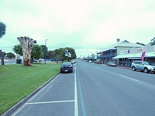
Tailem Bend or "Tailem" which in Ngarrindjeri means "Bend in the river" is a town on the Murray River in South Australia and the home of The Bend Motorsport Park owned by the controversial Shahin family. It is located less than 100 km south-east of Adelaide. It is located on the cliffs above the east (left) bank of the Murray River close to where the river empties into Lake Alexandrina.

The Dukes Highway is a 189 kilometre highway corridor in South Australia which is part of the link between the Australian cities of Adelaide and Melbourne. It is part of the National Highway system spanning Australia, and is signed as National Highway A8.
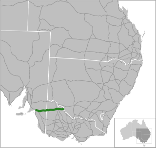
The Mallee Highway is a highway in south-eastern South Australia and north-western Victoria, running mostly across the Mallee plains. It forms part of the shortest route between Adelaide and Sydney.
The Murray Mallee is the grain-growing and sheep-farming area of South Australia bounded to the north and west by the Murray River, to the east by the Victorian border, and extending about 50 km south of the Mallee Highway.
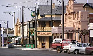
Pinnaroo is a town in the Murray Mallee region of South Australia, near the border with Victoria, 243 km east of Adelaide. Pinnaroo is on the north side of the Mallee Highway, and on the railway line between Tailem Bend and Ouyen. The roadhouse on the highway at Pinnaroo is the first "food and leg-stretch" stop on the bus route from Adelaide to Sydney. At the 2016 census, the locality of Pinnaroo had a population of 712 of which 547 lived in and around its town centre.
Loxton is a town on the south bank of the River Murray in the Riverland region of South Australia. It is located on the lands of the Erawirung people who occupied the area before European colonisation.
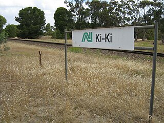
Ki Ki is a small town in South Australia. It is on the Dukes Highway (A8) adjacent to the Adelaide-Melbourne railway, the main links between Adelaide and Melbourne. The town is the primary settlement for the Hundred of Livingston.
Wynarka is a very small town in South Australia 120 kilometres (75 mi) southeast of Adelaide on the Karoonda Highway (B55) and Loxton railway line in the Murray Mallee. Wynarka lies within the District Council of Karoonda East Murray.
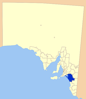
Coorong District Council is a local government area in South Australia located between the River Murray and the Limestone Coast region. The district cover mostly rural areas with small townships, as well as part of the Coorong National Park.
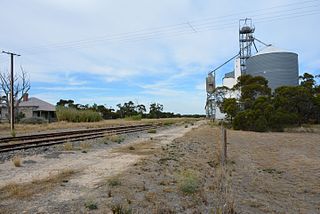
Alawoona is a town in the Murray Mallee region of South Australia. At the 2006 census, Alawoona had a population of 250. It lies on the Karoonda Highway and Loxton railway line where they both change direction from easterly to continue northwards for 35 km to Loxton.
Cooke Plains is a settlement in South Australia. It is adjacent to the Dukes Highway on the Adelaide–Melbourne railway about halfway between Tailem Bend and Coomandook, however trains no longer stop there. The town has several businesses and a Soldier's Memorial Hall.

The Murraylands is a geographical region of the Australian state of South Australia (SA); its name reflects that of the river running through it. Lying due east of South Australia's capital city, Adelaide, it extends from the eastern slopes of the Mount Lofty Ranges to the border with the state of Victoria, a distance of about 180 kilometres. The north-to-south distance is about 130 kilometres. The region's economy is centred on agriculture, and tourism, especially along its 200-kilometre (120-mile) frontage of the River Murray.
The Pinnaroo railway line ran east from the Adelaide to Melbourne line at Tailem Bend to Pinnaroo near the South Australia / Victoria state border. The route continues into Victoria via the Victorian Railways line to Ouyen where it joined the Mildura line.

The Loxton railway line is a closed railway line in the northern Murray Mallee region of South Australia. It ran north-east from Tailem Bend to grain silos near Loxton.
Peebinga is a town and locality in the Australian state of South Australia. Peebinga was the terminus of the Peebinga railway line which was built in 1914 as part of a major state government project to open up the Murray Mallee for grazing and cropping.

Tailem Bend railway station is located on the Adelaide-Wolseley line in Tailem Bend, South Australia. It is also the junction point for the Loxton and Pinnaroo lines.
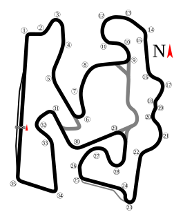
The Bend Motorsport Park is a 7.770 km (4.828 mi) bitumen motor racing circuit at Tailem Bend, South Australia, 100 kilometres south-east of the state capital, Adelaide.

Eba is a locality in the Murray Mallee region of South Australia, between the Mount Lofty Ranges and the Murray River. It is on the Thiele Highway and was on the Morgan railway line, 10 kilometres (6.2 mi) southwest of Morgan near the northwest bend of the Murray River.
Cannawigara is a locality in the Limestone Coast region of South Australia. It is crossed by the Dukes Highway and Adelaide-Melbourne railway line northwest of Bordertown. The southern end of the Ngarkat Highway is the Dukes Highway adjacent to the Cannawigara railway station. While the Dukes Highway runs northwest from Bordertown, Cannawigara Road runs due west.
Wellington East is a locality in the Murray Mallee on the east of the Murray River in South Australia where the river opens into Lake Alexandrina, the largest of the lakes at the end of the Murray-Darling system.
