Dukes Highway

Last updated

Dukes Highway

Dukes Highway
Australia South Australia location map.svg
Red pog.svg
Northwest end
Red pog.svg
Southeast end
Coordinates
General information
TypeHighway
Length190 km (118 mi) [1]
Route number(s)
  • AUS Alphanumeric Route A8.svg A8 (2017–present)
    Entire route
  • Concurrencies:
  • AUS Alphanumeric Route B57.svg B57 (1998–present)
    (Cannawigara–Bordertown)
Former
route number
  • Australian national highway A8.svg National Highway A8 (1998–2017)
  • Australian national highway 8.svg National Highway 8 (1974–1998)
  • Australian national route 8.svg National Route 8 (1955–1974)
Major junctions
Northwest endAUS Alphanumeric Route A1.svgAUS Alphanumeric Route B1.svg Princes Highway
Tailem Bend, South Australia
 
Southeast endAUS Alphanumeric Route A8.svg Western Highway
SA/VIC border
Location(s)
Region Murray and Mallee, Limestone Coast [2]
Major settlements Coonalpyn, Keith, Bordertown
Highway system

Dukes Highway is a 190 kilometre [1] highway corridor in South Australia, which is part of the link between the Australian cities of Adelaide and Melbourne. It is part of the National Highway system spanning Australia, and is signed as route A8.

Contents

Route

Dukes Highway begins at the intersection with Princes Highway in Tailem Bend. It heads in a southeast direction to the state border with Victoria just east of Bordertown, continuing into Victoria as Western Highway, with the same route signage (route A8). It is mostly a single carriageway of one lane each way, with 36 overtaking lanes. [3] Approximately 90 kilometres (56 mi) has 'wide centre lines', providing a 1.2 metres (3 ft 11 in) boundary between traffic travelling in opposite directions. [4]

Generally, the quality of Dukes Highway is of a high standard, with the entire road having wide lane widths and sealed shoulders with at least five (and usually six) metres clear beyond the edge line. [5] There are 16 rest areas or parking bays along the Dukes Highway, at approximately 15km intervals. Each one provides sealed parking space for at least four B-double trucks, with bins, tables, shelter and lighting. [6]

History

Dukes Highway runs through the northern part of the Limestone Coast region of South Australia. The route and many of the settlements, including Bordertown, were established in the 1850s to supply water to horses for the gold escorts from the Victorian goldfields to Adelaide. [7]

Gold was taken to Adelaide rather than the closer Melbourne because a higher price was offered there. The higher price was offered to stop the South Australian economy from collapsing, as all the labourers were heading to the Victorian Goldfields. The Bullion Act was passed and an Assay office was established in Adelaide for the assaying and stamping of gold in 1852. It is claimed that this saved South Australia from bankruptcy. [8]

By the 1930s, the series of separate tracks had started to coalesce into the route it follows today, and was already being referred to as "the Duke's Highway" – after the Duke of York, later King George VI [9] – but at the time the name had never been officially recognised. There was a push to name the road Tolmer Highway, after former police commissioner Alexander Tolmer of gold escort fame, but this never eventuated. [9]

In the latter half of the 20th century, the western end of Dukes Highway was realigned to meet the Mallee Highway closer to Tailem Bend. It previously ran north from Coomandook on the alignment that is now known as the Old Dukes Highway to Moorlands. [10]

The final 17 km of the highway after Bordertown, was originally built on unstable ground, and was re-constructed in 2005. [11]

Safety

Dukes Highway is South Australia's deadliest major road, with 28 deaths in the 5 years to 2009. [12] This has led to calls for road improvements to separate traffic in each direction with a dual carriageway. [13] Point-to-point speed cameras have been installed on one section of the highway to identify drivers who flout the speed limit. [14]

Parts of the highway have wider centre lines installed, with audio tactile treatment to help drivers to realise and recover from drifting across the centre line before they encounter an oncoming vehicle. This is intended to reduce fatigue and inattention-related crashes. [15]

Major intersections

StateLGA [16] Location [1] [17] km [1] miDestinationsNotes
South Australia Coorong Tailem Bend 0.00.0AUS Alphanumeric Route A1.svgAUS Alphanumeric Route B1.svg Princes Highway (A1 north, B1 south)  Adelaide, Murray Bridge, Meningie Northwestern terminus of highway and route A8
1.91.2 Adelaide–Wolseley railway line
3.01.9AUS Alphanumeric Route B12.svg Mallee Highway (B12)  Lameroo, Pinnaroo
Coomandook 31.719.7Old Dukes Highway  Moorlands
Coonalpyn 61.338.1McIntosh Way  Meningie
Tintinara 94.959.0 Adelaide–Wolseley railway line
Tatiara Keith 12578AUS Alphanumeric Route A66.svg Riddoch Highway (A66)  Naracoorte, Penola, Mount Gambier
Cannawigara 161100AUS Alphanumeric Route B57.svg Ngarkat Highway (B57 north)  Pinnaroo, Loxton Concurrency with route B57
Bordertown 171106AUS Alphanumeric Route B57.svg Naracoorte Road (B57 south)  Naracoorte, Penola, Mount Gambier
172107 Adelaide–Wolseley railway line
Wolseley 190120AUS Alphanumeric Route A8.svg Dukes Highway (A8)Southeastern terminus of Dukes Highway
State borderSouth Australia – Victoria state border
Victoria West Wimmera Serviceton AUS Alphanumeric Route A8.svg Western Highway (A8)  Horsham, Ballarat, Melbourne Western terminus of Western Highway, route A8 continues east

See also

Related Research Articles

<span class="mw-page-title-main">Princes Highway</span> Highway in Australia

Princes Highway is a major road in Australia, extending from Sydney via Melbourne to Adelaide through the states of New South Wales, Victoria and South Australia. It has a length of 1,941 kilometres (1,206 mi) or 1,898 kilometres (1,179 mi) via the former alignments of the highway, although these routes are slower and connections to the bypassed sections of the original route are poor in many cases.

<span class="mw-page-title-main">Sturt Highway</span> Australian national highway

Sturt Highway is an Australian national highway in New South Wales, Victoria, and South Australia. It is an important road link for the transport of passengers and freight between Sydney and Adelaide and the regions along the route.

<span class="mw-page-title-main">Tailem Bend, South Australia</span> Town in South Australia

Tailem Bend is a rural town in South Australia, 85 kilometres south-east of the state capital of Adelaide. It is located on the lower reaches of the River Murray, near where the river flows into Lake Alexandrina. It is linear in layout since it is constrained by river cliffs on its western side and the Adelaide–Melbourne railway line is dominant on its eastern side. The town grew and consolidated through being a large railway centre between the 1890s and 1990s; now it continues to service regional rural communities. In the 2021 census, Tailem Bend and the surrounding area had a population of 1,705.

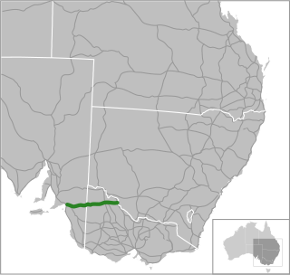
South Eastern Freeway is a 73 km (45 mi) freeway in South Australia (SA). It is a part of the National Highway network linking the state capital cities of Adelaide, SA, and Melbourne, Victoria, and is signed as route M1. It carries traffic over the Adelaide Hills between Adelaide and the River Murray, near Murray Bridge, where it is connected via the Swanport Bridge to the Dukes Highway, which is the main road route to Victoria.

Southern Expressway is an 18.5 km (11.5 mi) freeway through the southern suburbs of Adelaide, South Australia. It is the southern part of the North–South Corridor which extends the full length of Adelaide and is being built to urban freeway standard. It is designated part of route M2.

<span class="mw-page-title-main">Mallee Highway</span>

Mallee Highway is a highway in south-eastern South Australia and north-western Victoria, running mostly across the Mallee plains. It forms part of the shortest route between Adelaide and Sydney.

Port Wakefield Highway is an important South Australian highway, connecting Adelaide to the Yorke Peninsula, Port Augusta, northern and western South Australia, the Northern Territory and Western Australia. It is designated National Highway A1 and a part of the National Highway. It is named after Port Wakefield, the first government town north of Adelaide.

<span class="mw-page-title-main">Port Wakefield, South Australia</span> Town in South Australia

Port Wakefield is a town at the mouth of the River Wakefield, at the head of the Gulf St Vincent in South Australia. It was the first government town to be established north of the state capital, Adelaide. Port Wakefield is situated 98.7 kilometres from the Adelaide city centre on the Port Wakefield Highway section of the A1 National Highway.

<span class="mw-page-title-main">Bordertown, South Australia</span> Town in South Australia

Bordertown, formerly Border Town, is a town and locality in the Australian state of South Australia located in the state's east near the state border with Victoria about 250 kilometres (160 mi) east of the state capital of Adelaide. It is where the Dukes Highway and the railway line cross the Tatiara Creek between Adelaide and Melbourne, the capital of Victoria.

South Road and its southern section as Main South Road outside of Adelaide is a major north–south conduit connecting Adelaide and the Fleurieu Peninsula, in South Australia. It is one of Adelaide's most important arterial and bypass roads. As South Road, it is designated part of route A2 within suburban Adelaide. As Main South Road, it is designated part of routes A13 and B23.

Port River Expressway is a 5.7-kilometre (3.5 mi) freeway-grade road. The expressway links Port Adelaide and the LeFevre Peninsula across the north-western suburbs of Adelaide to major interstate routes via North-South Motorway.

Salisbury Highway is a 15 kilometre major connecting road in the northern suburbs of the Adelaide metropolitan area. It is designated part of route A9.

<span class="mw-page-title-main">Swanport Bridge</span> Bridge in Murray Bridge, South Australia

Swanport Bridge is a road bridge that carries Highway 1 across the Murray River, located approximately 4 kilometres (2.5 mi) southeast of the town of Murray Bridge in South Australia, Australia. Opened on 30 May 1979 by transport minister Geoff Virgo, the bridge connects the communities of Murray Bridge and Tailem Bend.

Gawler Bypass is a major north–south route in the outer northern suburbs of the city of Adelaide, South Australia, connecting Main North Road to the Sturt Highway, bypassing Gawler. The route was built in 1963 in an attempt to redirect traffic on the national highway out of Gawler town centre. It has been upgraded and realigned several times since then.

The Adelaide–Wolseley railway line is a 313 kilometre line running from Adelaide to Wolseley on the Australian Rail Track Corporation network. It is the South Australian section of the Melbourne–Adelaide railway.

Adelaide has two city ring routes, that loop around the Adelaide city centre and North Adelaide, known as the Inner and Outer Ring Routes.

<span class="mw-page-title-main">North–South Motorway</span> Motorway in Adelaide, South Australia

The North–South Motorway is a partially complete motorway traversing the inner western suburbs of Adelaide, from Waterloo Corner in the north to Bedford Park in the south. Progressively constructed in stages since 2010, once complete it will replace the adjacent South Road as Adelaide's main north–south roadway. It will form the central section of the North–South Corridor, being flanked north and south by the Northern Expressway and Southern Expressway, respectively. It is designated part of route M2.

Transport in South Australia is provided by a mix of road, rail, sea and air transport. The capital city of Adelaide is the centre to transport in the state. With its population of 1.4 million people, it has the majority of the state's 1.7 million inhabitants. Adelaide has the state's major airport and sea port.

<span class="mw-page-title-main">Mount Barker Road</span> Road in South Australia

Mount Barker Road was once the main road from Adelaide through the Adelaide Hills to Mount Barker on the eastern slopes of the Mount Lofty Ranges. The main route has now been replaced, or subsumed into, the South Eastern Freeway, but two sections of it remain, and are still classified as state roads.

Elwomple is a locality in The Coorong District Council in the South Australian Murray Mallee, southeast of Tailem Bend. The northwest corner is the junction of the Mallee Highway which forms the northern boundary of Elwomple, and the Dukes Highway which forms the southwestern boundary. The Bend Motorsport Park was developed in Elwomple adjacent to this junction. In September 2017, before the facility opened, the boundary between Tailem Bend and Elwomple was adjusted so that The Bend Motorsport Park was officially in Tailem Bend, not Elwomple.

References

  1. 1 2 3 4 Google (28 June 2022). "Dukes Highway" (Map). Google Maps . Google. Retrieved 28 June 2022.
  2. "Location SA Map viewer with regional layers". Government of South Australia . Retrieved 16 June 2022.
  3. "Overtaking Lanes". Department of Planning, Transport and Infrastructure, Government of South Australia. 22 June 2015. Archived from the original on 8 January 2017. Retrieved 8 January 2017.
  4. "Wide Centreline Treatment Strategy". Department of Planning, Transport and Infrastructure, Government of South Australia. 22 June 2015. Archived from the original on 8 January 2017. Retrieved 8 January 2017.
  5. "Roadside Hazard Management (Clear Zones)". Department of Planning, Transport and Infrastructure, Government of South Australia. 22 June 2015. Archived from the original on 8 January 2017. Retrieved 8 January 2017.
  6. "Rest Areas". Department of Planning, Transport and Infrastructure, Government of South Australia. 22 June 2015. Archived from the original on 8 January 2017. Retrieved 8 January 2017.
  7. From interpretive signs in Bordertown and along the route
  8. The Story of Keith 1851-1973, Fry, LPH 1953
  9. 1 2 "EYRE'S NAME NOT INCLUDED". The News . Adelaide: National Library of Australia. 17 June 1938. p. 5. Retrieved 31 October 2022.
  10. South Australia. Highways and Local Government Department.; South Australian Government Tourist Bureau. (1950), South Australia showing main road system and important district roads, Highways & Local Government Department, ; M.E. Sherrah, Government photolithographer, retrieved 28 June 2016
  11. "Dukes Highway pavement rehabilitation". AusLink . Retrieved 16 September 2006.[ permanent dead link ]
  12. Dukes Highway rated SA's deadliest, ABC, 20 Jan 2012.
  13. David Nankervis (29 March 2013). "Two killed after B-double and car collide head-on along Dukes Highway". The Advertiser . News Limited . Retrieved 17 October 2014.
  14. Glenn Power (11 February 2014). "Dukes Highway speed cameras almost ready". Murray Valley Standard. Fairfax Media. Retrieved 17 October 2014.
  15. "Wide Centreline Treatment Strategy". Department of Planning, Transport and Infrastructure, Government of South Australia. 30 January 2013. Archived from the original on 21 October 2014. Retrieved 17 October 2014.
  16. "Location SA Map viewer with LGA layers". Government of South Australia . Retrieved 16 June 2022.
  17. "Location SA Map viewer with suburb layers". Government of South Australia . Retrieved 16 June 2022.