
Riddoch Highway is a rural highway in south-eastern South Australia, designated as route A66 between Keith and Mount Gambier, with the remainder between Mount Gambier and Port MacDonnell designated as route B66. It is named after John Riddoch, the first white settler landholder and vigneron in Coonawarra.
Lincoln Highway is a highway in South Australia which links the cities of Port Augusta and Port Lincoln located on the east coast of Eyre Peninsula over a distance of 315 kilometres. Lincoln Highway - along with Flinders Highway - presents an alternative but somewhat longer coastal route between Ceduna and Port Augusta, compared to the more direct route along Eyre Highway.
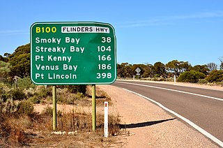
Flinders Highway connects the South Australian towns of Ceduna and Port Lincoln, a distance of 396 kilometres (246 mi), and is currently signed as B100. Flinders Highway - along with Lincoln Highway - presents an alternative but somewhat longer coastal route between Ceduna and Port Augusta, compared to the more direct route along Eyre Highway.
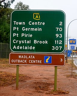
Port Wakefield Highway is an important South Australian highway, connecting Adelaide to the Yorke Peninsula, Port Augusta, northern and western South Australia, the Northern Territory and Western Australia. It is designated National Highway A1 and a part of the National Highway. It is named after Port Wakefield, the first government town north of Adelaide.
Tod Highway is an important 177 kilometre highway serving South Australia's Eyre Peninsula's wheatbelt, and is designated route B90. It is named after Robert Tod who explored the area in 1839.

Main North Road is the major north-south arterial route through the suburbs north of the Adelaide City Centre in the city of Adelaide, South Australia. It continues north through the settled areas of South Australia and is a total of 307 kilometres (191 mi) long, from North Adelaide to 21 kilometres (13 mi) out of Port Augusta. It follows the route established in the early years of the colony by explorer John Horrocks and was a major route for farmers and graziers to reach the capital, passing through rich farmland and the Clare Valley wine region. In 2011, the section of road between Gawler to Wilmington was renamed Horrocks Highway.
Northern Expressway, also known as the Fatchen Northern Expressway, is a 21 kilometre long controlled-access highway in Adelaide, South Australia. Since March 2020, the North–South Motorway continues west of Port Wakefield Highway and intersects the Port River Expressway to reach the harbour at Port Adelaide. These are the northernmost two parts of the North–South Corridor.
Salisbury Highway is a 15 kilometre major connecting road in the northern suburbs of the Adelaide metropolitan area. It is designated part of route A9.

Tapleys Hill Road is a north–south arterial road which runs parallel to the coast through western Adelaide, Australia. This name covers many consecutive streets and is not widely known to most drivers except for the northernmost section, as the entire allocation is still best known as by the names of its constituent parts: Tapleys Hill Road proper, Brighton Road, Ocean Boulevard, Lonsdale Road, Dyson Road, Murray Road, and Gawler Street. This article will deal with the entire length of the corridor for sake of completion, as well to avoid confusion between declarations.
Marion Road is a north–south arterial road through the western suburbs of Adelaide, South Australia, named after its traversal through the suburb of Marion and the local government area of City of Marion. It is designated part of route A14.

Goyder Highway (B64) is a west–east link through the Mid North region of South Australia connecting Spencer Gulf to the Riverland. It is part of the most direct road route from Port Augusta to much of Victoria and southern New South Wales.
Augusta Highway is the part of Australia's ring route located in South Australia between Port Wakefield and Port Augusta. It was named Augusta Highway in 2011, and was formerly known simply as Highway One.

RM Williams Way is a road through the Yorke and Mid North region of South Australia connecting Clare in the south through Spalding, Jamestown and Orroroo to Hawker in the Flinders Ranges. The road was named after R. M. Williams who had a strong association with the countryside through which it runs.

Flinders Ranges Way is the main road route through the Flinders Ranges in South Australia. It starts from the Augusta Highway at Stirling North, 6 km southeast of Port Augusta. The Flinders Ranges Way extends 209 km to Blinman. Route B83 follows the Flinders Ranges Way through Quorn to Hawker, but then branches onto The Outback Highway along the western side of the ranges through Leigh Creek to Lyndhurst.
Spencer Highway is a highway along the east coast of Spencer Gulf in South Australia. It runs south from Augusta Highway through Port Pirie to Minlaton.
Wilkins Highway is an east–west route across the Yorke and Mid North region of South Australia. It runs from Augusta Highway south of Port Pirie east to Barrier Highway at the town of Hallett, near where Sir Hubert Wilkins was born.
Yorke Highway is the main road from Adelaide to the southern parts of the Yorke Peninsula in South Australia. It runs from the northeast to the southwest of the peninsula. It branches off Copper Coast Highway after rounding the top of Gulf St Vincent, runs down the coast to Ardrossan then inland through Maitland to the Spencer Gulf coast at Hardwicke Bay then through Warooka to the south coast at Marion Bay and Stenhouse Bay on Investigator Strait.
St Vincent Highway is a major road on the southern part of Yorke Peninsula in South Australia. It diverges from Yorke Highway to continue south along the coast of Gulf St Vincent near Pine Point. It passes inland of Port Vincent, Stansbury, Wool Bay and Port Giles then passes through Coobowie and Edithburgh. From here, the St Vincent Highway turns northwest to Yorketown and west to Warooka where it rejoins Yorke Highway.
Birdseye Highway is an east–west road across Eyre Peninsula in South Australia. It was named for Sylvia Birdseye who drove the first bus service to the area from Adelaide for 43 years, starting in 1928, and the first highway in South Australia to be named for a woman.
Browns Well Highway is a road connecting Loxton, South Australia through the Murray Mallee to Pinnaroo in South Australia. It was named in 2008 after the Browns Well district for areas traversed by the highway.
