Mount Davies Road

Last updated

Mount Davies Road

Mount Davies Road 0116.svg
A map of Mount Davies Road and Kintore Avenue
Australia South Australia location map.svg
Red pog.svg
Northwest end
Red pog.svg
Southeast end
Coordinates
General information
Type Track
Length397 km (247 mi) [1]
Built by Len Beadell
Major junctions
Northwest end Gunbarrel Highway
Pipalyatjara, South Australia
Southeast end Anne Beadell Highway
Anne's Corner, South Australia
Location(s)
Region Far North [2]
Restrictions
Permitsrequired
Fuel supplynone

Mount Davies Road is a remote unsealed outback track which runs from Mount Davies (Pipalyatjara) in the far north-west corner of South Australia to Anne's Corner on the Anne Beadell Highway 397 kilometres to the south-east. [3] It was built during 1956 and 1957 by the Gunbarrel Road Construction Party (GRCP) surveyed and led by Len Beadell, for the Weapons Research Establishment at Woomera, South Australia. [4]

Contents

Road survey

As a result of British atomic tests at Emu Field in 1953, a weather station was needed to the far north-west of the test sites, to determine when suitable weather conditions existed for future tests. Len Beadell was given the task of selecting a team and constructing access roads from the test locality to the future weather station. The weather station was named Giles, after the explorer Ernest Giles who had explored that part of the remote inland. [5]

The access road began at Victory Downs in the Northern Territory and became known as the Gunbarrel Highway. The construction party reached Mount Davies in the Tomkinson Ranges at the north-west corner of South Australia in December 1955. [4]

In June 1956, after the Gunbarrel Highway had reached Giles, and the airstrip was laid out, Beadell returned to Mount Davies to begin a solo reconnaissance towards the south-east to survey a route for another road to link up with Emu Field. There had been recent rains which made the going tough, and early in the journey he suspected that a front axle of his four-wheel drive vehicle was broken due to slow progress in moist sand. He continued on as he had seen a cluster of rocky mountains in the distance, Mount Lindsay, which was useful as a survey trig point. The mountains reminded him of Ayers Rock by the smooth, rounded shape of the formation. [6]

After scaling the highest point, he noticed water in a creek below, which he later explored from the Land Rover. The vehicle sank into soft sand, and it took him until the next day to extricate himself, as only the rear wheels were driving. He decided that the new road would pass by this feature due to the good supply of water. [7]

He pressed on through thick scrub, and was more than halfway to the destination when he noticed that fuel usage was greater than normal because of the moist ground. He began to doubt if there was sufficient fuel left to make it Emu Field. The vehicle was equipped with a high-frequency radio, so he was still able to contact his base, but suddenly the rear axle broke and further progress ceased with 110 kilometres to go. [7]

Beadell used his theodolite at night for astronomical observations, and calculated his exact location the next morning which he was able to pass to base via radio. It was a week before a rescue team arrived. The wrong parts had been brought, so the vehicle was left where it was. It was repaired at a later date, and the survey was able to be completed. [7]

Road building

Beadell sign at Annes Corner Beadell sign to Mt Davies.JPG
Beadell sign at Annes Corner

Beadell returned to Mount Davies in July 1956 and led the GRCP with a bulldozer and grader back towards Emu Field, to begin construction of the new road. [7] The supply truck and fitter's truck experienced mechanical problems early on, so they had to be towed by the grader until Beadell was able to drive to Giles to pick up vital spares, after they had been delivered by aircraft. Near Mt. Lindsay, the bulldozer became bogged in soft ground, and almost simultaneously the grader was bogged some distance away. It took two days of hard work to extricate both machines.

Sites for a mobile meteorological station were surveyed at Mount Lindsay and Coffin Hill in August. In September, work was halted while British scientists visited Giles, and was not restarted until the following year in June 1957. A point on a previously made road 48 kilometres west of Emu Field was reached in July, with the corner named Anne's Corner, after Beadell's future wife. In 1958, work continued on the Gunbarrel Highway. [4]

Kintore Avenue

Four years after the Mount Davies Road was completed, Beadell and the GRCP built a new road connecting the Gunbarrel Highway to the Mount Davies Road, in order to shorten travelling time from the east. They started just south of the Mann Ranges on 10 May 1961. They proceeded in a southerly direction and intercepted the Mount Davies Road about 50 kilometres south of Mount Lindsay on 6 June, a distance of 153 km. It was named Kintore Avenue after Mount Kintore, [8] a feature visible on the eastern side of the new road. [4]

Present conditions

The entire length of the Mount Davies Road lies within the Anangu Pitjantjatjara lands. A note on the reference map states "All roads and tracks in the Anangu Pitjantjatjara Land area are not accessible by the general public." [3]

See also

Related Research Articles

<span class="mw-page-title-main">Connie Sue Highway</span> Track in Western Australia

The Connie Sue Highway is an outback unsealed track that runs between the Aboriginal community of Warburton on the Great Central Road and Rawlinna on the Trans-Australian Railway. It lies entirely in the state of Western Australia, crosses the Great Victoria Desert and Nullarbor Plain, and is approximately 650 km (400 mi) long.

<span class="mw-page-title-main">Gunbarrel Highway</span> Track in Australia

The Gunbarrel Highway is an isolated desert track in the Northern Territory, South Australia and Western Australia. It consists of about 1,350 km (840 mi) of washaways, heavy corrugations, stone, sand and flood plains. The Gunbarrel Highway connects Victory Downs in the Northern Territory to Carnegie Station in Western Australia. Some sources incorrectly show the highway extending west to Wiluna.

<span class="mw-page-title-main">Len Beadell</span> Australian explorer

Leonard Beadell OAM BEM FIEMS was a surveyor, road builder, bushman, artist and author, responsible for constructing over 6,000 km (3,700 mi) of roads and opening up isolated desert areas – some 2.5 million square kilometres – of central Australia from 1947 to 1963. Born in West Pennant Hills, New South Wales, Beadell is sometimes called "the last true Australian explorer".

<span class="mw-page-title-main">Anne Beadell Highway</span> Australian outback track

Anne Beadell Highway is an outback unsealed track linking Coober Pedy, South Australia, and Laverton, Western Australia, a total distance of 1,325 km (823 mi). The track was surveyed and built by Len Beadell, Australian surveyor, who named it after his wife.

Kalka is an Aboriginal community in the Anangu Pitjantjatjara Yankunytjatjara Lands in South Australia administered under the Anangu Pitjantjatjara Yankunytjatjara Land Rights Act 1981.

<span class="mw-page-title-main">Great Central Road</span> Track in Western Australia and the Northern Territory

The Great Central Road is a mostly unsealed Australian outback highway that runs 1,126 km (700 mi) from Laverton, Western Australia to Yulara, Northern Territory. It passes through a number of small communities on the way. It forms part of the Outback Way which goes all the way to Winton, Queensland.

Pipalyatjara is an Aboriginal community in the Anangu Pitjantjatjara Yankunytjatjara Lands in South Australia, comprising one of the six main communities on "The Lands". Other smaller communities include Nyapari, Kanpi, Kalka, Yunyarinyi. At the 2016 census, Pipalyatjara had a population of 189. The residents are mainly Anangu who speak Pitjantjatjara as their first language.The closest community is Kalka to the West.

Kaltukatjara, also known as Docker River, is a remote Indigenous Australian community in the Northern Territory of Australia. It is southwest of Alice Springs, west of the Stuart Highway, near the Western Australia and Northern Territory border. The township is on a wadi called the Docker Creek on the north side of the west end of the Petermann Ranges in the southwest corner of the Northern Territory of Australia.

<span class="mw-page-title-main">Gary Highway</span> Track in Western Australia

The Gary Highway is a remote unsealed track in central Western Australia running through the Gibson Desert and the Great Sandy Desert. It was built by Len Beadell's Gunbarrel Road Construction Party in April and May 1963 and named after Beadell's son, who was born in February that year. It connects the Gunbarrel Highway from Everard Junction in the south, to the Gary Junction Road at Gary Junction in the north. It is one of only two north-south tracks in the central deserts of Western Australia, the other being the Sandy Blight Junction Road, also built by Len Beadell.

<span class="mw-page-title-main">Giles Weather Station</span> Remote weather station in Western Australia

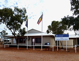
Giles Weather Station is located in Western Australia near the Northern Territory border, about 750 kilometres (470 mi) west-south-west of Alice Springs and 330 kilometres (210 mi) west of Uluru. It is the only staffed weather station within an area of about 2,500,000 square kilometres (970,000 sq mi) and is situated mid-continent and near the core of the subtropical jetstream. This means it plays an important role as a weather and climate observatory for the country, particularly eastern and southeastern Australia, and particularly for rainfall predictions. The station is on the Great Central Road and the nearest township is the Warakurna Aboriginal settlement, 5 kilometres (3 mi) North. Giles is within the Shire of Ngaanyatjarraku and is in the foothills of the Rawlinson Ranges.

<span class="mw-page-title-main">Sandy Blight Junction Road</span> Track in the Northern Territory and Western Australia

The Sandy Blight Junction Road is a remote outback track in Australia joining the Great Central Road, Western Australia and Gary Junction Road, Northern Territory. It was built under the direction of legendary surveyor Len Beadell as part of a network of roads for the Weapons Research Establishment at Woomera, South Australia. It is located approximately 500 km (310 mi) west of Alice Springs.

<span class="mw-page-title-main">Gunbarrel Road Construction Party</span> Team of Australian road builders

The Gunbarrel Road Construction Party (GRCP) was the name bestowed upon a team of road builders by Len Beadell in 1955, after which the well known outback track Gunbarrel Highway was named. Over a period of eight years, Beadell and the GRCP built more than 6,000 kilometres of dirt roads in remote areas of central Australia for the Weapons Research Establishment at Woomera, South Australia.

<span class="mw-page-title-main">Gary Junction Road</span> Track in the Northern Territory and Western Australia

The Gary Junction Road is an outback unsealed road in Australia built by Len Beadell in the 1960s as part of a network of roads for the Weapons Research Establishment at Woomera, South Australia. In its original form, the Gary Junction Road ran from Liebig bore in the Northern Territory to Callawa Station in Western Australia. On present day maps, it is depicted as running from the Tanami Road to Gary Junction, just east of the Canning Stock Route, a distance of 852 kilometres. The road was named after Beadell's only son Gary.

<span class="mw-page-title-main">Talawana Track</span> Remote track in Western Australia

The Talawana Track is a remote unsealed track that runs between Windy Corner on the Gary Highway and the Marble Bar Road in Western Australia, a distance of 596 kilometres. The majority of it was built by Len Beadell and the Gunbarrel Road Construction Party in 1963 as part of a series of connecting roads for the Woomera rocket range in South Australia. It was the final road they built.

<span class="mw-page-title-main">Jackie Junction</span> Road junction in Western Australia

Jackie Junction is a remote location in Western Australia on the Gunbarrel Highway. It was named by the road builder Len Beadell after his youngest daughter and is at the junction of the original Gunbarrel Highway and the road to Warburton. It is 69 kilometres (43 mi) north of Warburton.

Giles Airport services the Warakurna Community and the Giles Weather Station in eastern Western Australia. The airstrip was built during April and May 1956 by a team led by Len Beadell as part of establishing the weather station for the British nuclear tests at Maralinga and the Woomera Test Range. It is adjacent to the Gunbarrel Highway and the more recently constructed Great Central Road.

<span class="mw-page-title-main">Mount Beadell</span>

Mount Beadell is a mountain located in the Gibson Desert region of Western Australia. It is named after surveyor and explorer Len Beadell, builder of the Gunbarrel Highway. The location is very remote being 155 km (96 mi) west of Jackie Junction and 295 km (183 mi) east of Carnegie Station, the western terminus of the original Gunbarrel Highway.

<span class="mw-page-title-main">Maralinga to Emu Road</span>

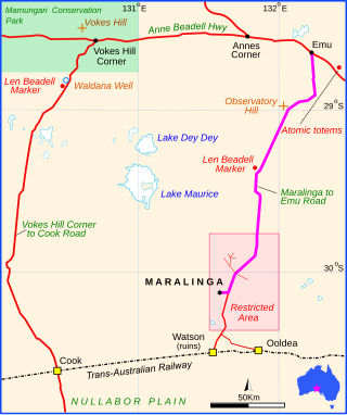
Maralinga to Emu Road is a remote unsealed outback track that links Maralinga to Emu in the western region of South Australia. It was built by Len Beadell for the Weapons Research Establishment of Salisbury, South Australia in 1955.

<span class="mw-page-title-main">Vokes Hill Corner to Cook Road</span> Unsealed outback track in Australia

Vokes Hill Corner to Cook Road is a remote unsealed outback track that links Vokes Hill Corner on the Anne Beadell Highway to Cook on the Trans-Australian Railway in the far west of South Australia. It was built by Len Beadell for the Australian Government's Weapons Research Establishment in late 1961.

Mount Davies, is a mountain in the Tomkinson Ranges in the north-west corner of South Australia, with an altitude of about 1,039 metres (3,409 ft) above sea level.

References

  1. Google (13 July 2022). "Mount Davies Road" (Map). Google Maps . Google. Retrieved 13 July 2022.
  2. "Location SA Map viewer with regional layers". Government of South Australia . Retrieved 16 June 2022.
  3. 1 2 Hema, Maps (2005). Australia’s Great Desert Tracks SC Sheet (Map). Eight Mile Plains Queensland: Hema Maps. ISBN   978-1-86500-164-7.
  4. 1 2 3 4 Shephard, Mark (1998). A Lifetime in the Bush:The biography of Len Beadell. Adelaide: Corkwood Press. ISBN   1876247053.
  5. Joy, William (1964). The Explorers. Adelaide: Rigby Ltd. p. 72. ISBN   0-85179-112-3.
  6. Beadell, Len (1971). Bush Bashers. New Holland Publishers (Australia). ISBN   1864367342.
  7. 1 2 3 4 Bayly, Ian (2009). Len Beadell's Legacy. Seaford Vic: Bas Publishing. ISBN   9781921496028.
  8. Governor of South Australia 1889-1895