
The Blue Mountains are a mountainous region and a mountain range located in New South Wales, Australia. The region is considered to be part of the western outskirts of the Greater Sydney Region, The region borders on Sydney's main metropolitan area, its foothills starting about 50 kilometres (31 mi) west of centre of the state capital, close to Penrith on the outskirts of Greater Sydney region. The public's understanding of the extent of the Blue Mountains is varied, as it forms only part of an extensive mountainous area associated with the Great Dividing Range. As defined in 1970, the Blue Mountains region is bounded by the Nepean and Hawkesbury rivers in the east, the Coxs River and Lake Burragorang to the west and south, and the Wolgan and Colo rivers to the north. Geologically, it is situated in the central parts of the Sydney Basin.

Uluṟu-Kata Tjuṯa National Park is a protected area in the Northern Territory of Australia. The park is home to both Uluru and Kata Tjuta. It is located 1,943 kilometres (1,207 mi) south of Darwin by road and 440 kilometres (270 mi) south-west of Alice Springs along the Stuart and Lasseter Highways. The park covers 1,326 square kilometres (512 sq mi) and includes the features it is named after: Uluru and, 40 kilometres (25 mi) to its west, Kata Tjuta. The location is listed as a UNESCO World Heritage Site for natural and cultural landscape.

Uluru, also known as Ayers Rock and officially gazetted as Uluru / Ayers Rock, is a large sandstone formation in the centre of Australia. It is in the southern part of the Northern Territory, 335 km (208 mi) southwest of Alice Springs.

Gosses Bluff is thought to be the eroded remnant of an impact crater. Known as Tnorala to the Western Arrernte people of the surrounding region, it is located in the southern Northern Territory, near the centre of Australia, about 175 km (109 mi) west of Alice Springs and about 212 km (132 mi) to the northeast of Uluru. It was named by Ernest Giles in 1872 after Australian explorer William Gosse's brother Henry, who was a member of William's expedition.
Ngarutjaranya, also known as Mount Woodroffe, is a mountain in the Australian state of South Australia, located in the Anangu Pitjantjatjara Yankunytjatjara lands in the state's northwest. It is South Australia's highest peak, at 1,435 metres (4,708 ft).

The Flinders Ranges are the largest mountain ranges in South Australia, which starts about 200 km (125 mi) north of Adelaide. The ranges stretch for over 430 km (265 mi) from Port Pirie to Lake Callabonna.
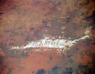
Lake Amadeus is a large salt lake in the southwest corner of Northern Territory of Australia, about 50 kilometres (31 mi) north of Uluru. The smaller Lake Neale is adjacent to the northwest. It is part of the Amadeus Basin that was filled with the erosion products of the Petermann Orogeny.
Musgrave Ranges is a mountain range in Central Australia, straddling the boundary of South Australia and the Northern Territory, extending into Western Australia. It is between the Great Victoria Desert to the south and the Gibson Desert to the north. They have a length of 210 kilometres (130 mi) and many peaks that have a height of more than 1,100 metres (3,600 ft), the highest being Ngarutjaranya at 1,435 metres (4,708 ft).

The geology of Australia includes virtually all known rock types, spanning a geological time period of over 3.8 billion years, including some of the oldest rocks on earth. Australia is a continent situated on the Indo-Australian Plate.

The Petermann Orogeny was an Australian intracontinental event that affected basement rocks of the northern Musgrave Province and Ediacaran (Proterozoic) sediments of the (now) southern Amadeus Basin between ~550-535 Ma. The remains are seen today in the Petermann Ranges.
The Musgrave Block is an east-west trending belt of Proterozoic granulite-gneiss basement rocks approximately 500 kilometres (310 mi) long. The Musgrave Block extends from western South Australia into Western Australia.
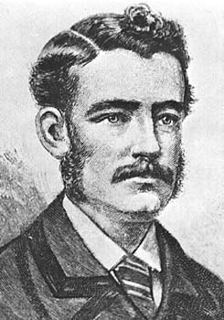
William Christie Gosse, was an Australian explorer, who was born in Hoddesdon, Hertfordshire, England and immigrated to Australia with his father Dr. William Gosse in 1850. He was educated at J. L. Young's Adelaide Educational Institution and in 1859 he entered the Government service of South Australia. He held various positions in the survey department, including Deputy Surveyor-General. He died of a heart attack on 12 August 1881, aged 38, after a long illness.
The Alice Springs Orogeny was a major intraplate tectonic episode in central Australia responsible for the formation of a series of large mountain ranges. The deformation associated with the Alice Spring Orogeny caused the vertically-tilted sandstone layers of the iconic Uluru/Ayers Rock.
Kaltjiti is an Aboriginal community in Anangu Pitjantjatjara Yankunytjatjara in South Australia, comprising one of the six main communities on "The Lands".
The Petermann Ranges are a mountain range in central Australia. They run 320 km (200 mi) across the border between Western Australia and the southwest corner of the Northern Territory.
Mount Unapproachable is an isolated mountain in the Northern Territory of Australia located in the locality of Petermann on the northern side of Lake Neale in the territory's southwest. It is about 505 metres (1,657 ft) above sea level. The area is remote: the nearest towns are Kaltukatjara some 116 kilometres (72 mi) away, Kintore some 135 kilometres (84 mi) away and Yulara 138 kilometres (86 mi) away. The mountain is mostly made of sandstone.
The Tomkinson Ranges is a mountain range in the northwest corner of South Australia. The range consists of sandstone hills, surrounded by spinifex grasslands. The range was named after politician Samuel Tomkinson (1816–1900) by the explorer William Gosse in the early 1870s. Ernest Giles and his team reached the ranges shortly after, and established a base from which to explore the Gibson and Great Victoria Deserts. Numerous prospecting expeditions were made through the region until the 1930s.

European land exploration of Australia deals with the opening up of the interior of Australia to European settlement which occurred gradually throughout the colonial period, 1788–1900. A number of these explorers are very well known, such as Burke and Wills who are well known for their failed attempt to cross the interior of Australia, as well as Hamilton Hume and Charles Sturt.

Acacia basedowii, commonly known as Basedow's wattle, is a shrub belonging to the genus Acacia and the subgenus Phyllodineae endemic to arid parts of central Australia.
This is a list of mountain ranges, including ranges of hills, that occur in Australia.
