
Eyre Highway is a 1,664-kilometre (1,034 mi) highway linking Western Australia and South Australia via the Nullarbor Plain. Signed as National Highways 1 and A1, it forms part of Highway 1 and the Australian National Highway network linking Perth and Adelaide. It was named after explorer Edward John Eyre, who was the first European to cross the Nullarbor by land, in 1840–1841. Eyre Highway runs from Norseman in Western Australia, past Eucla, to the state border. Continuing to the South Australian town of Ceduna, it then crosses the top of the Eyre Peninsula before reaching Port Augusta.
Lincoln Highway is a highway in South Australia which links the cities of Port Augusta and Port Lincoln located on the east coast of Eyre Peninsula over a distance of 315 kilometres. Lincoln Highway - along with Flinders Highway - presents an alternative but somewhat longer coastal route between Ceduna and Port Augusta, compared to the more direct route along Eyre Highway.
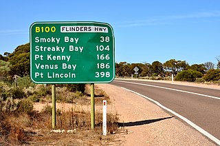
Flinders Highway connects the South Australian towns of Ceduna and Port Lincoln, a distance of 396 kilometres (246 mi), and is currently signed as B100. Flinders Highway - along with Lincoln Highway - presents an alternative but somewhat longer coastal route between Ceduna and Port Augusta, compared to the more direct route along Eyre Highway.
The Eyre Peninsula is a triangular peninsula in South Australia. It is bounded by the Spencer Gulf on the east, the Great Australian Bight on the west, and the Gawler Ranges on the north.
Port Wakefield Highway is an important South Australian highway, connecting Adelaide to the Yorke Peninsula, Port Augusta, northern and western South Australia, the Northern Territory and Western Australia. It is designated National Highway A1 and a part of the National Highway. It is named after Port Wakefield, the first government town north of Adelaide.
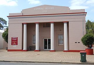
Cummins is a town on Eyre Peninsula in South Australia, 67 km north of Port Lincoln and 60 m above sea level. At the 2011 census, the town had a population of 719.

The City of Port Lincoln is a local government area located on the southern tip of the Eyre Peninsula in South Australia. It consists of one suburb - Port Lincoln. It is surrounded on land by the District Council of Lower Eyre Peninsula, which also has offices in Port Lincoln.
Southern Ports Highway is a 119 kilometres rural highway in South Australia that connects Kingston SE with Millicent via Rendelsham, Southend, Beachport and Robe. It is a former alignment of Princes Highway, bypassed in 1933.

Wilmington–Ucolta Road is a 100 kilometre major road connecting Port Augusta to Peterborough and beyond to Broken Hill, in South Australia. This name covers many consecutive streets and is not widely known to most drivers except, as the entire allocation is still best known as by the names of its constituent parts: Willowie Road, Petersburg Road, and its concurrency along RM Williams Way. This article will deal with the entire length of the corridor for sake of completion, as well to avoid confusion between declarations.
Salisbury Highway is a 15 kilometre major connecting road in the northern suburbs of the Adelaide metropolitan area. It is designated part of route A9.
Boston is a locality on the Eyre Peninsula of South Australia, situated in the District Council of Lower Eyre Peninsula. It consists of a coastal section immediately north of Port Lincoln and a broader area inland; while it is residential along the coast, much of the locality remains semi-rural. The name and boundaries were formalised in October 2003 for the long established local name. On 15 October 2009, sections of Boston were severed and added to North Shields and the new locality of Tiatukia, while a portion of adjacent Hawson was added to Boston.

Goyder Highway (B64) is a west–east link through the Mid North region of South Australia connecting Spencer Gulf to the Riverland. It is part of the most direct road route from Port Augusta to much of Victoria and southern New South Wales.
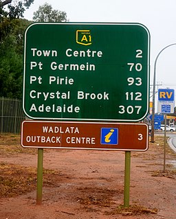
Augusta Highway is the part of Australia's ring route located in South Australia between Port Wakefield and Port Augusta. It was named Augusta Highway in 2011, and was formerly known simply as Highway One.
Copper Coast Highway is a highway in South Australia which branches off from the Augusta and Port Wakefield Highways 2 km north of Port Wakefield, and heads northwest across the top of Yorke Peninsula to Kadina, ending at the Spencer Gulf town of Wallaroo.
Spencer Highway is a highway along the east coast of Spencer Gulf in South Australia. It runs south from Augusta Highway through Port Pirie to Minlaton.
Yorke Highway is the main road from Adelaide to the southern parts of the Yorke Peninsula in South Australia. It runs from the northeast to the southwest of the peninsula. It branches off Copper Coast Highway after rounding the top of Gulf St Vincent, runs down the coast to Ardrossan then inland through Maitland to the Spencer Gulf coast at Hardwicke Bay then through Warooka to the south coast at Marion Bay and Stenhouse Bay on Investigator Strait.
St Vincent Highway is a major road on the southern part of Yorke Peninsula in South Australia. It diverges from Yorke Highway to continue south along the coast of Gulf St Vincent near Pine Point. It passes inland of Port Vincent, Stansbury, Wool Bay and Port Giles then passes through Coobowie and Edithburgh. From here, the St Vincent Highway turns northwest to Yorketown and west to Warooka where it rejoins Yorke Highway.
Birdseye Highway is an east–west road across Eyre Peninsula in South Australia. It was named for Sylvia Birdseye who drove the first bus service to the area from Adelaide for 43 years, starting in 1928, and the first highway in South Australia to be named for a woman.
Edillilie is a small town on Eyre Peninsula in South Australia. It is on the Tod Highway and Eyre Peninsula Railway north of Port Lincoln.
Duck Ponds is a locality in the Australian state of South Australia located on the Eyre Peninsula in the state's west about 258 kilometres (160 mi) west of the state capital of Adelaide, about 51 kilometres (32 mi) south of the municipal seat of Cummins and about 6 kilometres (3.7 mi) west of the city of Port Lincoln.

