The Eyre Peninsula is a triangular peninsula in South Australia. It is bounded by the Spencer Gulf on the east, the Great Australian Bight on the west, and the Gawler Ranges to the north.

Seal Bay Conservation Park is a protected area located on the south coast of Kangaroo Island in the Australian state of South Australia. It is the home of the third largest Australian sea lion colony in Australia.
The Investigator Group is an archipelago in South Australia that consists of Flinders Island and five island groups located off the western coast of the Eyre Peninsula. It is named after HMS Investigator by her commander, Matthew Flinders when he explored the area in 1802. The Group lies within the Great Australian Bight. All the islands except Flinders Island, and a part of Pearson Island, are within the Investigator Group Wilderness Protection Area and the Waldegrave Islands Conservation Park.

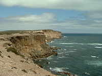
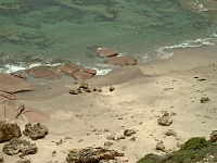
Point Labatt Conservation Park is a protected area occupying Point Labatt on the west coast of Eyre Peninsula in South Australia about 39 kilometres South by east of Streaky Bay. The conservation park was proclaimed in July 1973 under the National Parks and Wildlife Act 1972 for the purpose of protecting what is considered to be ‘the largest colony of Australian sea lions on mainland Australia’. The conservation park was formed on land donated in 1972 by Ron, Myra and Ellen Freeman who were concerned that ‘illegal shooting was threatening these once endangered animals.’ The Point Labatt Aquatic Reserve, an associated protected area, was proclaimed in October 1988 under the Fisheries Act 1982 for the purpose of protecting an area of adjoining ocean used by the colony as a feeding ground. The conservation park is classified as an IUCN Category III protected area.
Nicolas Baudin Island Conservation Park is a protected area associated with Nicolas Baudin Island which is located off Cape Blanche on the west coast of Eyre Peninsula in South Australia about 30 kilometres south of Streaky Bay. The conservation park was proclaimed in 2003 under the National Parks and Wildlife Act 1972 to ‘protect a significant breeding location for the Australian sea lion.’
Smooth Island is an island in the Australian state of South Australia located off the west coast of Eyre Peninsula about 52 kilometres south west of the town of Ceduna. It is both part of a local group of islands known as the Isles of St Francis group and a larger group known as the Nuyts Archipelago. It has enjoyed protected area status since the 1960s and since 2011, it has been part of the Nuyts Archipelago Wilderness Protection Area.
Beatrice Islets are pair of islets in the Australian state of South Australia located in Nepean Bay on the north coast of Kangaroo Island about 4 kilometres east of Kingscote. The islets and adjoining intertidal areas are notable as habitat for bird life. The islet pair has enjoyed protected area status since 1909 and since at least 1972, have been part of the Beatrice Islet Conservation Park. During either the 1960s or the 1970s, the islets were extensively damaged by an exercise to remove an infestation of South African boxthorn.
Nicolas Baudin Island is an island in the Australian state of South Australia about 500 metres west of Cape Blanche on the west coast of Eyre Peninsula about 25 kilometres south south-west of the town of Streaky Bay. The island is notable as a breeding site for Australian sea lions. The island has enjoyed protected area status since 2003 when it became part of the Nicolas Baudin Island Conservation Park.
Ward Islands is an island group in the Australian state of South Australia located in the Investigator Group about 53 kilometres west by south of Cape Finniss on the west coast of Eyre Peninsula. The group was discovered and named by Matthew Flinders on 13 February 1802. The island group has enjoyed protected area status since the 1960s and since 2011, it been part of the Investigator Group Wilderness Protection Area.
Topgallant Islands is an island group in the Australian state of South Australia located in the Investigator Group about 22 kilometres south west of Cape Finniss on the west coast of Eyre Peninsula. The group was discovered and named by Matthew Flinders on 13 February 1802. The island group has enjoyed protected area status since the 1960s and since 2011, it has been part of the Investigator Group Wilderness Protection Area.

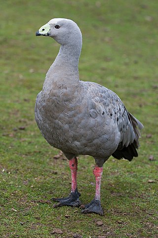
Waldegrave Islands is an island group in the Australian state of South Australia located in the Investigator Group about 2.5 kilometres northwest by west of Cape Finniss on the west coast of Eyre Peninsula. The group consists of Waldegrave Island, Little Waldegrave Island and according to some sources, a pair of rocks known as the Watchers. The group is notable as a breeding site for Australian sea lions and Cape Barren geese. The group has enjoyed protected area status since the 1960s and as of 1972 has been part of the Waldegrave Islands Conservation Park.
Cape Radstock is a headland located on the west coast of Eyre Peninsula in South Australia about 45 kilometres south south-east of the town of Streaky Bay and about 9.3 kilometres (5 nmi) south east of Point Labatt. The cape is both the north western extremity of Anxious Bay and the southern extremity of the Calca Peninsula. The cape is described as being “steep and bold” and where the cliffs reach a height of 135 metres, being the high point of a line of cliffs starting at Point Labatt in the west and from within Anxious Bay in the east. It was named by Matthew Flinders on 9 February 1802 after William Waldegrave, 1st Baron Radstock. Since 2012, the waters adjoining its shoreline are within a habitat protection zone in the West Coast Bays Marine Park.
Calca Peninsula is a peninsula in the Australian state of South Australia located on the west coast of Eyre Peninsula in the locality of Sceale Bay about 27 kilometres to about 46 kilometres south-east of the town of Streaky Bay.
Jones Island is an island in the Australian state of South Australia located at the mouth of Baird Bay in the north end of Anxious Bay about 45 kilometres south-southeast of the town of Streaky Bay on the west coast of Eyre Peninsula. The island is notable as a breeding site for Australian sea lions and Australian pelicans. The island has enjoyed protected area status since 1967 and as of 1972, it has been part of the Baird Bay Islands Conservation Park.
Dorothee Island is an island in the Australian state of South Australia which is part of the Pearson Isles which itself is part of the larger island grouping known as the Investigator Group. It is located about 69 kilometres west south-west of Cape Finniss on the west coast of Eyre Peninsula. It was discovered as part of the Pearson Isles by Matthew Flinders on 13 February 1802. The island was given its name in August 1969 in order to preserve a name used within the locality by the Baudin expedition. The island has enjoyed protected area status since at least 1972 and since 2011, it been part of the Investigator Group Wilderness Protection Area.
Royston Island is an island in the Australian state of South Australia at the northern end of Pondalowie Bay on the south-west extremity of Yorke Peninsula about 13 kilometres north-west of the town of Stenhouse Bay. The island has enjoyed protected area status since 1967 and since 1972, it has been part of the Innes National Park.

South Island is an island located in the Australian state of South Australia at the south end of Pondalowie Bay on the south-west extremity of Yorke Peninsula about 11 kilometres north-west by west of the town of Stenhouse Bay. The island has enjoyed protected area status since 1970 and since 1977, it has been part of the Innes National Park.
Unnamed island is an island located in South Australia within Baird Bay about 32 kilometres south by west of the town of Streaky Bay on the west coast of Eyre Peninsula. The island has enjoyed protected area status since 1967 and it has been part of the Baird Bay Islands Conservation Park since 1972.
Hardwicke Bay is a bay in the Australian state of South Australia located on the west coast of Yorke Peninsula in Spencer Gulf.

Point Labatt Aquatic Reserve is a marine protected area in the Australian state of South Australia located in the waters of the Great Australian Bight adjoining the west coast of Eyre Peninsula at the headland of Point Labatt.