
Lindow Man, also known as Lindow II and as Pete Marsh, is the preserved bog body of a man discovered in a peat bog at Lindow Moss near Wilmslow in Cheshire, North West England. The remains were found on 1 August 1984 by commercial peat cutters. Lindow Man is not the only bog body to have been found in the moss; Lindow Woman was discovered the year before, and other body parts have also been recovered. The find was described as "one of the most significant archaeological discoveries of the 1980s" and caused a media sensation. It helped invigorate study of British bog bodies, which had previously been neglected.

A bog or bogland is a wetland that accumulates peat as a deposit of dead plant materials – often mosses, typically sphagnum moss. It is one of the four main types of wetlands. Other names for bogs include mire, mosses, quagmire, and muskeg; alkaline mires are called fens. A baygall is another type of bog found in the forest of the Gulf Coast states in the United States. They are often covered in heath or heather shrubs rooted in the sphagnum moss and peat. The gradual accumulation of decayed plant material in a bog functions as a carbon sink.

In geology, a hummock is a small knoll or mound above ground. They are typically less than 15 meters (50 ft) in height and tend to appear in groups or fields. Large landslide avalanches that typically occur in volcanic areas are responsible for formation of hummocks. From the initiation of the landslide to the final formation, hummocks can be characterized by their evolution, spatial distribution, and internal structure. As the movement of landslide begins, the extension faulting results in formation of hummocks with smaller ones at the front of the landslide and larger ones in the back. The size of the hummocks is dependent on their position in the initial mass. As this mass spreads, the hummocks further modify to break up or merger to form larger structures. It is difficult to make generalizations about hummocks because of the diversity in their morphology and sedimentology. An extremely irregular surface may be called hummocky.

Frost heaving is an upwards swelling of soil during freezing conditions caused by an increasing presence of ice as it grows towards the surface, upwards from the depth in the soil where freezing temperatures have penetrated into the soil. Ice growth requires a water supply that delivers water to the freezing front via capillary action in certain soils. The weight of overlying soil restrains vertical growth of the ice and can promote the formation of lens-shaped areas of ice within the soil. Yet the force of one or more growing ice lenses is sufficient to lift a layer of soil, as much as 1 foot or more. The soil through which water passes to feed the formation of ice lenses must be sufficiently porous to allow capillary action, yet not so porous as to break capillary continuity. Such soil is referred to as "frost susceptible". The growth of ice lenses continually consumes the rising water at the freezing front. Differential frost heaving can crack road surfaces—contributing to springtime pothole formation—and damage building foundations. Frost heaves may occur in mechanically refrigerated cold-storage buildings and ice rinks.

Burns Bog is an ombrotrophic peat bog located in Delta, British Columbia, Canada. It is the largest raised peat bog and the largest undeveloped urban land mass on the West Coast of the Americas. Burns Bog was originally 4,000–4,900 hectares before development. Currently, only 3,500 hectares remain of the bog.

Cranberry Glades — also known simply as The Glades — are a cluster of five small, boreal-type bogs in southwestern Pocahontas County, West Virginia, United States. This area, high in the Allegheny Mountains at about 3,400 feet (1,000 m), is protected as the Cranberry Glades Botanical Area, part of the Monongahela National Forest. This site is the headwaters of the Cranberry River, a popular trout stream, and is adjacent to the nearly 50,000-acre (200 km2) Cranberry Wilderness.

Pingos are intrapermafrost ice-cored hills, 3–70 m (10–230 ft) high and 30–1,000 m (98–3,281 ft) in diameter. They are typically conical in shape and grow and persist only in permafrost environments, such as the Arctic and subarctic. A pingo is a periglacial landform, which is defined as a non-glacial landform or process linked to colder climates. It is estimated that there are more than 11,000 pingos on Earth. The Tuktoyaktuk peninsula area has the greatest concentration of pingos in the world with a total of 1,350 pingos. There is currently remarkably limited data on pingos.
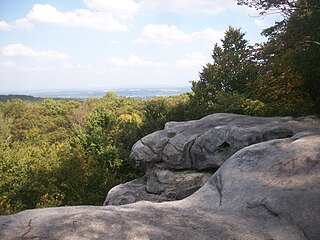
Forbes State Forest is a Pennsylvania state forest in Pennsylvania Bureau of Forestry District #4. The main offices are located in Laughlintown in Westmoreland County, Pennsylvania in the United States. Mount Davis, the highest peak in Pennsylvania, is located in the forest.

A string bog or string mire is a bog consisting of slightly elevated ridges and islands, with woody plants, alternating with flat, wet sedge mat areas. String bogs occur on slightly sloping surfaces, with the ridges at right angles to the direction of water flow. They are an example of patterned vegetation.

A pocosin is a type of palustrine wetland with deep, acidic, sandy, peat soils. Groundwater saturates the soil except during brief seasonal dry spells and during prolonged droughts. Pocosin soils are nutrient-deficient (oligotrophic), especially in phosphorus.

Westhay Moor is a 513.7-hectare (1,269-acre) biological Site of Special Scientific Interest 2.5 kilometres (1.6 mi) north-east of Westhay village and 4 kilometres (2.5 mi) from Wedmore in Somerset, England, notified in 1971. Westhay Moor is also notified as part of the Somerset Levels and Moors Special Protection Area under the EU Birds Directive and as a Ramsar site, and a National Nature Reserve.
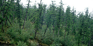
Drunken trees, tilted trees, or a drunken forest, is a stand of trees rotated from their normal vertical alignment.

Patterned ground is the distinct and often symmetrical natural pattern of geometric shapes formed by the deformation of ground material in periglacial regions. It is typically found in remote regions of the Arctic, Antarctica, and the Outback in Australia, but is also found anywhere that freezing and thawing of soil alternate; patterned ground has also been observed in the hyper-arid Atacama Desert and on Mars. The geometric shapes and patterns associated with patterned ground are often mistaken as artistic human creations. The mechanism of the formation of patterned ground had long puzzled scientists but the introduction of computer-generated geological models in the past 20 years has allowed scientists to relate it to frost heaving, the expansion that occurs when wet, fine-grained, and porous soils freeze.

Palsas are peat mounds with a permanently frozen peat and mineral soil core. They are a typical phenomenon in the polar and subpolar zone of discontinuous permafrost. One of their characteristics is having steep slopes that rises above the mire surface. This leads to the accumulation of large amounts of snow around them. The summits of the palsas are free of snow even in winter, because the wind carries the snow and deposits on the slopes and elsewhere on the flat mire surface. Palsas can be up to 150 m in diameter and can reach a height of 12 m.

Raised bogs, also called ombrotrophic bogs, are acidic, wet habitats that are poor in mineral salts and are home to flora and fauna that can cope with such extreme conditions. Raised bogs, unlike fens, are exclusively fed by precipitation (ombrotrophy) and from mineral salts introduced from the air. They thus represent a special type of bog, hydrologically, ecologically and in terms of their development history, in which the growth of peat mosses over centuries or millennia plays a decisive role. They also differ in character from blanket bogs which are much thinner and occur in wetter, cloudier climatic zones.
A frost boil, also known as mud boils, a stony earth circles, frost scars, or mud circles, are small circular mounds of fresh soil material formed by frost action and cryoturbation. They are found typically found in periglacial or alpine environments where permafrost is present, and may damage roads and other man-made structures. They are typically 1 to 3 metres in diameter.
Cashel Man is a bog body from a bog near Cashel in County Laois, Ireland. He was found on 10 August 2011 by Bord na Móna employee Jason Phelan from Abbeyleix. The body was a young adult male, around 20–25, who had been intentionally covered with peat after death. The crouched figure was recovered after being damaged by a milling machine in 2011. The head and left arm were presumed destroyed by the peat harvester, until later recovered.
A mire, peatland, or quagmire is a wetland area dominated by living peat-forming plants. Mires arise because of incomplete decomposition of organic matter, usually litter from vegetation, due to water-logging and subsequent anoxia. All types of mires share the common characteristic of being saturated with water, at least seasonally with actively forming peat, while having their own ecosystem. Like coral reefs, mires are unusual landforms that derive mostly from biological rather than physical processes, and can take on characteristic shapes and surface patterning.
The Espy Bog is wetland complex in Columbia County, Pennsylvania, in the United States. It is situated near Bloomsburg and Espy. The wetlands contain a lake, as well as forested swamps, shrub swamps, and graminoid openings. The lake in the wetland complex may be manmade. The predominant soil in the area is known as mucky peat. The wetland complex has a high level of plant and animal biodiversity, including birds, turtles, fish, trees, shrubs, and ferns.
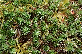
Polytrichum strictum, commonly known as bog haircap moss or strict haircap, is an evergreen and perennial species of moss native to Sphagnum bogs and other moist habitats in temperate climates. It has a circumboreal distribution, and is also found in South America and Antarctica.

