
Cley next the Sea (,, is a village and civil parish on the River Glaven in English county of Norfolk, 4 mi north-west of Holt and east of Blakeney. The main A149 coast road runs through the centre of the village, causing congestion in the summer months due to the tight, narrow streets. It lies within the Norfolk Coast AONB and the North Norfolk Heritage Coast.

Fairburn Ings Nature Reserve is a protected area in West Yorkshire, England, noted for its avian biodiversity. The reserve has recorded around 280 bird species, remarkable for an inland site in the United Kingdom. This is explained by the site being on migration routes as well as the diversity of habitats.

Whitkirk is a suburb of east Leeds, England. It is situated between Cross Gates to the north, Austhorpe to the east, Killingbeck to the west, Colton to the south-east and Halton to the south-west. The Temple Newsam estate lies directly south of the area.

The ING Group is a Dutch multinational banking and financial services corporation headquartered in Amsterdam. Its primary businesses are retail banking, direct banking, commercial banking, investment banking, wholesale banking, private banking, asset management, and insurance services. With total assets of US$1.1 trillion, it is one of the biggest banks in the world, and consistently ranks among the top 30 largest banks globally. It is among the top ten largest European companies by revenue.

Lexden is a suburb of Colchester and former civil parish, now in the unparished area of Colchester, in the Colchester district, in the county of Essex, England. It was formerly a village, and has previously been called Lessendon, Lassendene and Læxadyne. In 1891 the parish had a population of 3562. On 26 March 1897 the parish was abolished to form Colchester. Lexden is mentioned in the Domesday Book.

Lostwithiel is a civil parish and small town in Cornwall, England, United Kingdom at the head of the estuary of the River Fowey. According to the 2001 census it had a population of 2,739, increasing to 2,899 at the 2011 census. The Lostwithiel electoral ward had a population of 4,639 at the 2011 census. The name Lostwithiel comes from the Cornish "lostwydhyel" which means "tail of a wooded area".

Whernside is a mountain in the Yorkshire Dales in Northern England. It is the highest of the Yorkshire Three Peaks, the other two being Ingleborough and Pen-y-ghent. It is the highest point in the ceremonial county of North Yorkshire and the historic West Riding of Yorkshire with the summit lying on the county boundary with Cumbria. It is the fifteenth most prominent hill in England.

Harrow Weald is a suburban district in Greater London, England. Located about 2 miles (3.2 km) north of Harrow, Harrow Weald is formed from a leafy 1930s suburban development along with ancient woodland of Harrow Weald Common. It forms part of the London Borough of Harrow.

The Swale is a tidal channel of the Thames estuary that separates the Isle of Sheppey from the rest of Kent. On its banks is a 6,509.4-hectare (16,085-acre) biological Site of Special Scientific Interest which stretches from Sittingbourne to Whitstable in Kent. It is also a Ramsar internationally important wetland site and a Special Protection Area under the European Union Directive on the Conservation of Wild Birds. Parts of it are a Nature Conservation Review site, Grade I, National Nature Reserves, a Kent Wildlife Trust nature reserve and a Local Nature Reserve.

Wheldrake is a village and civil parish located 7 miles (11 km) south-east of York. Administratively it is in the unitary authority of the City of York in North Yorkshire, England. According to the 2001 census the parish had a population of 1,909, increasing to 2,107 at the 2011 Census.

The Yorkshire Wildlife Trust is a charitable non-governmental organisation, one of the UK's 46 county-based Wildlife Trusts. It's focus is nature conservation and it works to achieve a nature-rich Yorkshire with healthy and resilient ecosystems that support both Yorkshire's wildlife and its people.

RSPB Dearne Valley Old Moor is an 89-hectare (220-acre) wetlands nature reserve in the Dearne Valley near Barnsley, South Yorkshire, run by the Royal Society for the Protection of Birds (RSPB). It lies on the junction of the A633 and A6195 roads and is bordered by the Trans Pennine Trail long-distance path. Following the end of coal mining locally, the Dearne Valley had become a derelict post-industrial area, and the removal of soil to cover an adjacent polluted site enabled the creation of the wetlands at Old Moor.

Burnham Market is an English village and civil parish near the north coast of Norfolk. It is one of the Burnhams, a group of three adjacent villages that were merged: Burnham Sutton, Burnham Ulph and Burnham Westgate. In 2022, Burnham Market was rated among the "20 most beautiful villages in the UK and Ireland" by Condé Nast Traveler in 2020.

Allerton Bywater is a semi-rural village and civil parish in the south-east of the City of Leeds metropolitan borough in West Yorkshire, England. The population of the civil parish at the 2011 census was 4,717. The village itself is 2 miles (3.2 km) north of Castleford, with neighbouring villages Kippax and Great Preston all providing local amenities. St Aidan's Nature reserve borders the village attracting many visitors with its beauty and charm. Additionally "The Lines Way" bridle path which runs from Garforth through to Allerton following the old train track provides a pleasant route for walkers, joggers and cyclists alike. The River Aire flows through the village to the south-west.

Bishop Monkton is a village and civil parish in the Harrogate district of North Yorkshire, England, about five miles south of Ripon. According to the 2001 census it had a population of 775, increasing slightly to 778 at the 2011 Census. In 2015, North Yorkshire County Council estimated the population to be 760.
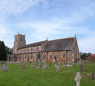
Dersingham is a village and civil parish in the English county of Norfolk. It is situated some 12 kilometres (7.5 mi) north of the town of King's Lynn and 70 km (43 mi) north-west of the city of Norwich, opening onto The Wash.

Hevingham is a village and civil parish in the Broadland district of the English county of Norfolk. Situated between the A140 road Norwich to Cromer road and the B1149 road Norwich to Holt road. It is 7 miles (11 km) north from the city of Norwich and 4 miles (6.4 km) south from the market town of Aylsham.
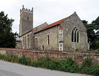
Foxley is a village and civil parish in the English county of Norfolk. The village is located 6 miles (9.7 km) north-east of Dereham and 15 miles (24 km) north-west of Norwich, along the A1067 between Fakenham and Norwich.

Newbourne is a village and civil parish in the East Suffolk region of Suffolk, England. It lies on the peninsula between the River Orwell and the River Deben, to the east of Ipswich and south of Woodbridge.

Bishop Monkton Ings is a Site of Special Scientific Interest, or SSSI, situated east of Bishop Monkton village in North Yorkshire, England. It consists mostly of marshy, calcareous grassland, with some broadleaved woodland, and some fen alongside the two watercourses which run through the site. This varied wetland forms a habitat for a variety of plants, including the semi-parasitic marsh lousewort (Pedicularis palustris).

