Hullshire, or the County of Hull, was a county of England from 1440 to 1889. Hullshire may refer to the area outside the town of Kingston upon Hull within the county, whilst the entire entity was sometimes referred to as the "Town and County of Hull".

The Arctic Corsair(H320) is a deep-sea trawler that was converted to a museum ship in 1999. It is berthed between Drypool Bridge and Myton Bridge in the River Hull in Kingston upon Hull, England, and is part of the city's Museums Quarter.

Cottingham is a large village and civil parish in the East Riding of Yorkshire, England with average affluence. It lies just north-west of the city of Kingston upon Hull, and 3.5 miles (5.6 km) from the city centre, and is part of the Hull urban area. Cottingham lies on the eastern fringe of the hills of the Yorkshire Wolds with a parish population of over 17,000 in 2011. Cottingham is one of the villages claiming to be the largest village in England.

Kingston upon Hull East is a constituency represented in the House of Commons of the UK Parliament since 2010 by Karl Turner of the Labour Party.

Hull Paragon Interchange is an integrated rail, bus and coach station in the city centre of Kingston upon Hull, England. The G.T. Andrews-designed station was originally named Paragon Station, and together with the adjoining Station Hotel, it opened in 1847 as the new Hull terminus for the growing traffic of the York and North Midland (Y&NMR) leased to the Hull and Selby Railway (H&S). As well as trains to the west, the station was the terminus of the Y&NMR and H&S railway's Hull to Scarborough Line. From the 1860s the station also became the terminus of the Hull and Holderness and Hull and Hornsea railways.

The Hull–Scarborough line, also known as the Yorkshire coast line, is a minor railway line in northern England used primarily for passenger traffic. It runs northwards from Hull Paragon via Beverley and Driffield to Bridlington, joining the York–Scarborough line at a junction near Seamer before terminating at Scarborough railway station.

The Kingston upon Hull tramway network was a network of 4 ft 8 1⁄2 instandard gauge tram lines following the five main roads radially out of the city centre of Kingston upon Hull, East Riding of Yorkshire, England. Two of these lines went west, and two east. The fifth went to the north, and branched to include extra lines serving suburban areas. Additionally a short line linked the city centre to the Corporation Pier where a ferry crossed the Humber Estuary to New Holland, Lincolnshire.

The Port of Hull is a port at the confluence of the River Hull and the Humber Estuary in Kingston upon Hull, East Riding of Yorkshire, England.

Drypool is an area within the city of Kingston upon Hull, England.

Orchard Park Estate is an area or housing estate situated on the north-western side of Kingston upon Hull, England.
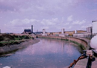
Stoneferry is a suburb of Kingston upon Hull, East Riding of Yorkshire, England. It was formerly a small hamlet on the east bank of the River Hull, the site of a ferry, and, after 1905, a bridge. The area is primarily industrial, and is situated on the east bank of the river, as well as close by areas on the west bank.
Gipsyville is a western suburb of Kingston upon Hull, in the East Riding of Yorkshire, England.

Newland is a suburb of Kingston upon Hull, East Riding of Yorkshire, England, in the north-west of the city, a former village on the Hull to Beverley turnpike.
Summergangs is a suburb of Kingston upon Hull, near the A165 road, in the East Riding of Yorkshire, England. The area contains the model village development known as The Garden Village, Kingston upon Hull, and the East Park.
Inglemire is a suburb of Kingston upon Hull, in the East Riding of Yorkshire, England.

The Charterhouse was a Carthusian monastery and almshouse in Kingston upon Hull, England, built just outside the town's walls. The hospital building survived the Dissolution of the Monasteries; the priory was destroyed in 1538. The structure of the hospital was destroyed before the first siege of Hull during the English Civil War. A replacement was built in 1645, which was replaced again in 1780; the buildings function as an almshouse with an attached chapel, and remain in use to the present day (2012).

Wilmington is an industrial area east of the River Hull in Kingston upon Hull, England.

Southcoates is an urban area in the eastern part of Kingston upon Hull, England.

Kingswood, occasionally referred to as Kingswood Parks, is a modern housing estate on the northern fringe of Kingston upon Hull, England.


