Notable beach meadow localities
Denmark has several beach meadows. Large and well-developed meadows can primarily be found in the Wadden Sea, Limfjord and Isefjord areas and on the islands of Læsø and Lolland, but there are many other smaller beach meadows throughout this low-lying country. On the Faroese Islands and in Greenland "fell meadows" can be found. They are usually not flooded by seawater, so it could be argued if they are truly beach meadows.
Iceland, Norway and some parts of Sweden, has extensive "fell meadows".
In the Baltic region, there are several beach meadows. Sweden can present true beach meadows on Öland and in some parts of Gotland, and Estonia has large beach meadows of international importance to migratory birds.
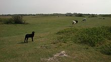
United Kingdom has several beach meadows throughout. They can be found in Cornwall and the country of Wales has several. Here the coast often consists of high cliffs, so the meadows are usually not flooded by seawater and strictly speaking they would be classified as "coastal meadows" or "fell meadows". Examples can be found on the Llŷn Peninsula, where cattle are grazing. Scotland has many fell meadows.
Ireland has large areas of fell meadows with grazing cattle.
On the American continent, Canada can present extensive fell meadows in Nova Scotia.

The South Bruny National Park is a national park located on Bruny Island, Tasmania, Australia, about 50 kilometres (31 mi) south of Hobart. The park contains the Cape Bruny Lighthouse. The highest point of the park is Mount Bruny at 504 metres (1,654 ft).

Holkham National Nature Reserve is England's largest national nature reserve (NNR). It is on the Norfolk coast between Burnham Overy Staithe and Blakeney, and is managed by Natural England with the cooperation of the Holkham Estate. Its 3,900 hectares comprise a wide range of habitats, including grazing marsh, woodland, salt marsh, sand dunes and foreshore. The reserve is part of the North Norfolk Coast Site of Special Scientific Interest, and the larger area is additionally protected through Natura 2000, Special Protection Area (SPA) and Ramsar listings, and is part of both an Area of Outstanding Natural Beauty (AONB) and a World Biosphere Reserve. Holkham NNR is important for its wintering wildfowl, especially pink-footed geese, Eurasian wigeon and brant geese, but it also has breeding waders, and attracts many migrating birds in autumn. A number of scarce invertebrates and plants can be found in the dunes, and the reserve is one of the only two sites in the UK to have an antlion colony.

The Oceanian realm is one of the World Wildlife Fund (WWF) biogeographic realms, and is unique in not including any continental land mass. It has the smallest land area of any of the WWF realms.

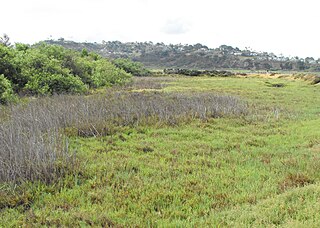
A salt marsh, saltmarsh or salting, also known as a coastal salt marsh or a tidal marsh, is a coastal ecosystem in the upper coastal intertidal zone between land and open saltwater or brackish water that is regularly flooded by the tides. It is dominated by dense stands of salt-tolerant plants such as herbs, grasses, or low shrubs. These plants are terrestrial in origin and are essential to the stability of the salt marsh in trapping and binding sediments. Salt marshes play a large role in the aquatic food web and the delivery of nutrients to coastal waters. They also support terrestrial animals and provide coastal protection.
Puckey's Estate Reserve is a coastal nature reserve in North Wollongong, New South Wales, Australia. It is mainly she-oak forest, but also has sand dune and wetland areas, including areas along Para Creek. It is located in the suburb of Fairy Meadow and is bounded by Fairy Meadow Beach to the east, Squires Way to the west, Elliotts Road to the north and Fairy Lagoon to the south.

California coastal prairie, also known as northern coastal grassland, is a grassland plant community of California and Oregon in the temperate grasslands, savannas, and shrublands biome. It is found along the Pacific Coast, from as far south as Los Angeles in Southern California to southern Oregon.

Fauna of Azerbaijan or animal kingdom of Azerbaijan refers to the diversity of various types of animals, which inhabit and populate a defined ground or water area in Azerbaijan.

Havergate Island is the only island in the county of Suffolk, England. It is found at the confluence of the River Ore and the Butley River near the village of Orford. It is a marshy nature reserve run by the Royal Society for the Protection of Birds (RSPB) and is known for its population of pied avocets and terns. It is part of the ecologically important Alde-Ore Estuary and has protected conservation status as part of a national nature reserve, SSSI, SAC, SPA, Ramsar Site and is also a part of the Suffolk Coast and Heaths AONB.

Wildlife of the Gambia is dictated by several habitat zones over its total land area of about 10,000 km2. It is bound in the south by the savanna and on the north by the Sudanian woodlands. The habitats host abundant indigenous plants and animals, in addition to migrant species and newly planted species. They vary widely and consist of the marine system, coastal zone, estuary with mangrove vegetation coupled with Banto Faros, river banks with brackish and fresh water zones, swamps covered with forests and many wetlands.
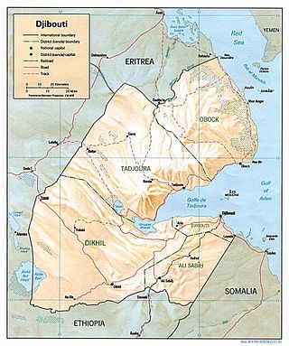
The wildlife of Djibouti, consisting of its flora and fauna, is in a harsh landscape with forest accounting for less than one percent of its area. Most species are found in the northern part of the country in the Day Forest National Park at an average elevation of 1,500 metres (4,900 ft), including the massif Goda, with a peak of 1,783 metres (5,850 ft). It covers an area of 3.5 square kilometres (1.4 sq mi) of Juniperus procera forest, with many of the trees rising to 20 metres (66 ft) height. This forest area is the main habitat of the critically endangered and endemic Djibouti spurfowl, and another recently noted vertebrate, Platyceps afarensis. The area also contains many species of woody and herbaceous plants, including boxwood and olive trees, which account for sixty percent of the identified species in the country.

Duinen van Texel National Park is a national park located on the North Holland island of Texel in the Netherlands. All dune systems on the western side of the island and the large coastal plains on both the northern and southern points of the island are part of the park. The park covers approximately 43 km2 (17 sq mi) and attained national park status in 2002. The visitor center is located in the natural history museum Ecomare.
Brackish marshes develop from salt marshes where a significant freshwater influx dilutes the seawater to brackish levels of salinity. This commonly happens upstream from salt marshes by estuaries of coastal rivers or near the mouths of coastal rivers with heavy freshwater discharges in the conditions of low tidal ranges.

Jigme Singye Wangchuck National Park covers an area of 1,730 square kilometres (670 sq mi) in central Bhutan. It protects a large area of the Black Mountains, a sub−range of the Himalayan Range System.

Egå Engsø is an artificial lake and wetland site located in the north of the town of Aarhus between Vejlby, Risskov and Lystrup. Engsø means 'meadow lake' and Egå means 'oak stream', referring to the stream that drains the lake into the Aarhus bay. The lake area is bordered by the Djursland motorway to the north and the Aarhus-Grenaa railway and the municipal heating pipes from Studstrup Power Station to the south and west.

Baldoyle Bay is a sea inlet on the east coast of Fingal in Ireland, in the historic County Dublin. It is situated between Portmarnock, at its head, and Baldoyle. It contains two small estuaries, those of the Sluice River and the Mayne River, and is sometimes called Baldoyle Estuary. The inlet is an important natural feature with protected status. It was once the site of a Viking longphort and later the fishing village of Baldoyle developed near its outlet to the sea.

Almindingen is one of the largest forests in Denmark. It is located in the centre of the island of Bornholm. The forest covers 3,800 hectares, making it Denmark's third largest. Though it was at one time common grazing land for cattle, it was fenced in for forestry in 1809 by Hans Rømer, the forest supervisor. As a result, by the beginning of the 20th century, Bornholm had become Denmark's most forested region.

Suffolk Coast National Nature Reserve is a wildlife reserve on the North Sea coast of the English county of Suffolk. It is located around the village of Walberswick to the south of the town of Southwold. The reserve was designated in 2003, combining the existing Walberswick National Nature Reserve with reserves at Dingle Marshes and Hen Reedbeds to create a 1,340 hectares reserve.

Mols Bjerge National Park or Nationalpark Mols Bjerge is a Danish national park in the area known as Mols Bjerge in Syddjurs Municipality, Central Jutland, inaugurated on 29 August 2009. The protected area, measures 180 square kilometres (69 sq mi) in size. The Mols Hills, reaching a height of 137 metres (449 ft), are centrally located in the park, and take up 2,500 ha. "More than half of all wild Danish plant species" can be found at Mols Bjerge.

Coastal meadows are meadows in the coastal zone, influenced by the sea.

Thy National Park is a national park area in Thy, Denmark, opened to the public on 22 August 2008. It is located in Northwest Jutland, along the coast from Hanstholm to Agger Tange and it spans 55 km (34 mi) north to south and 5–12 km (3.1–7.5 mi) east to west. The total area of the national park is 244 km2.