
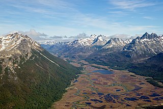
A swamp is a forested wetland. Swamps are considered to be transition zones because both land and water play a role in creating this environment. Swamps vary in size and are located all around the world. The water of a swamp may be fresh water, brackish water, or seawater. Freshwater swamps form along large rivers or lakes where they are critically dependent upon rainwater and seasonal flooding to maintain natural water level fluctuations. Saltwater swamps are found along tropical and subtropical coastlines. Some swamps have hammocks, or dry-land protrusions, covered by aquatic vegetation, or vegetation that tolerates periodic inundation or soil saturation. The two main types of swamp are "true" or swamp forests and "transitional" or shrub swamps. In the boreal regions of Canada, the word swamp is colloquially used for what is more formally termed a bog, fen, or muskeg. Some of the world's largest swamps are found along major rivers such as the Amazon, the Mississippi, and the Congo.

Peat is an accumulation of partially decayed vegetation or organic matter. It is unique to natural areas called peatlands, bogs, mires, moors, or muskegs. Sphagnum moss, also called peat moss, is one of the most common components in peat, although many other plants can contribute. The biological features of sphagnum mosses act to create a habitat aiding peat formation, a phenomenon termed 'habitat manipulation'. Soils consisting primarily of peat are known as histosols. Peat forms in wetland conditions, where flooding or stagnant water obstructs the flow of oxygen from the atmosphere, slowing the rate of decomposition. Peat properties such as organic matter content and saturated hydraulic conductivity can exhibit high spatial heterogeneity.

A wetland is a distinct semi-aquatic ecosystem whose groundcovers are flooded or saturated in water, either permanently, for years or decades, or only seasonally. Flooding results in oxygen-poor (anoxic) processes taking place, especially in the soils. Wetlands form a transitional zone between waterbodies and dry lands, and are different from other terrestrial or aquatic ecosystems due to their vegetation's roots having adapted to oxygen-poor waterlogged soils. They are considered among the most biologically diverse of all ecosystems, serving as habitats to a wide range of aquatic and semi-aquatic plants and animals, with often improved water quality due to plant removal of excess nutrients such as nitrates and phosphorus.

A fen is a type of peat-accumulating wetland fed by mineral-rich ground or surface water. It is one of the main types of wetland along with marshes, swamps, and bogs. Bogs and fens, both peat-forming ecosystems, are also known as mires. The unique water chemistry of fens is a result of the ground or surface water input. Typically, this input results in higher mineral concentrations and a more basic pH than found in bogs. As peat accumulates in a fen, groundwater input can be reduced or cut off, making the fen ombrotrophic rather than minerotrophic. In this way, fens can become more acidic and transition to bogs over time.

A bog or bogland is a wetland that accumulates peat as a deposit of dead plant materials – often mosses, typically sphagnum moss. It is one of the four main types of wetlands. Other names for bogs include mire, mosses, quagmire, and muskeg; alkaline mires are called fens. A bayhead is another type of bog found in the forest of the Gulf Coast states in the United States. They are often covered in heath or heather shrubs rooted in the sphagnum moss and peat. The gradual accumulation of decayed plant material in a bog functions as a carbon sink.

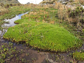
Sphagnum is a genus of approximately 380 accepted species of mosses, commonly known as sphagnum moss, also bog moss and quacker moss. Accumulations of Sphagnum can store water, since both living and dead plants can hold large quantities of water inside their cells; plants may hold 16 to 26 times as much water as their dry weight, depending on the species. The empty cells help retain water in drier conditions.

Burns Bog is an ombrotrophic peat bog located in Delta, British Columbia, Canada. It is the largest raised peat bog and the largest undeveloped urban land mass on the West Coast of the Americas. Burns Bog was originally 4,000–4,900 hectares before development. Currently, only 3,500 hectares remain of the bog.
Minerotrophic refers to environments that receive nutrients primarily through groundwater that flows through mineral-rich soils or rock, or surface water flowing over land. Minerotrophic, “minerogenous”, and “geogenous” are now often used interchangeably, although the latter two terms refer primarily to hydrological systems, while the former refers to nutrient dynamics. The hydrologic process behind minerotrophic wetlands results in water that has acquired dissolved chemicals which raise the nutrient levels and reduce the acidity. This in turn affects vegetation assemblages and diversity in the wetland in question. If dissolved chemicals include chemical bases such as calcium or magnesium ions, the water is referred to as base-rich and is neutral or alkaline. In contrast to minerotrophic environments, ombrotrophic environments get their water mainly from precipitation, and so are very low in nutrients and more acidic. Of the various wetland types, fens and rich fens are often minerotrophic while poor fens and bogs are often ombrotrophic. Marshes and swamps may also be fed through groundwater sources to a degree.

Aulacomnium palustre, the bog groove-moss or ribbed bog moss, is a moss that is nearly cosmopolitan in distribution. It occurs in North America, Hispaniola, Venezuela, Eurasia, and New Zealand. In North America, it occurs across southern arctic, subboreal, and boreal regions from Alaska and British Columbia to Greenland and Quebec. Documentation of ribbed bog moss's distribution in the contiguous United States is probably incomplete. It is reported sporadically south to Washington, Wyoming, Georgia, and Virginia.
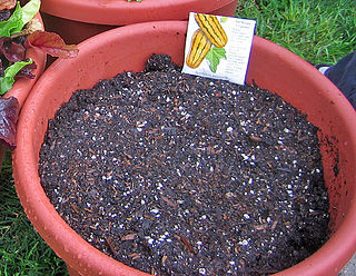
Potting soil or growing media, also known as potting mix or potting compost (UK), is a substrate used to grow plants in containers. The first recorded use of the term is from an 1861 issue of the American Agriculturist. Despite its name, little or no soil is usually used in potting soil.

Raised bogs, also called ombrotrophic bogs, are acidic, wet habitats that are poor in mineral salts and are home to flora and fauna that can cope with such extreme conditions. Raised bogs, unlike fens, are exclusively fed by precipitation (ombrotrophy) and from mineral salts introduced from the air. They thus represent a special type of bog, hydrologically, ecologically and in terms of their development history, in which the growth of peat mosses over centuries or millennia plays a decisive role. They also differ in character from blanket bogs which are much thinner and occur in wetter, cloudier climatic zones.

The Kopuatai Peat Dome is a large peatland complex on the Hauraki Plains in the North Island of New Zealand. It consists of two raised domes, one in the north and the other in the south, that are up to three metres higher at the center than at the edge. The 10,201 hectares wetland contains the largest intact raised bog in New Zealand and was listed under the Ramsar Convention in 1989 as a Wetland of International Importance. Most of the wetland is ombrotrophic, meaning it receives water and nutrient inputs solely from rain and is hydrologically isolated from the surrounding canals and rivers. Locally, a popular misconception persists that water flows from the nearby Piako River into the bog and that the wetland acts as a significant store for floodwater.

Greenhouse gas emissions from wetlands of concern consist primarily of methane and nitrous oxide emissions. Wetlands are the largest natural source of atmospheric methane in the world, and are therefore a major area of concern with respect to climate change. Wetlands account for approximately 20–30% of atmospheric methane through emissions from soils and plants, and contribute an approximate average of 161 Tg of methane to the atmosphere per year.
A peatland is a type of wetland whose soils consist of organic matter from decaying plants, forming layers of peat. Peatlands arise because of incomplete decomposition of organic matter, usually litter from vegetation, due to water-logging and subsequent anoxia. Peatlands are unusual landforms that derive mostly from biological rather than physical processes, and can take on characteristic shapes and surface patterning.
Cornelia Clermont Cameron was an American geologist who researched peat as a soil additive and energy source.
Bioclogging or biological clogging refers to the blockage of pore space in soil by microbial biomass, including active cells and their byproducts such as extracellular polymeric substance (EPS). The microbial biomass obstructs pore spaces, creating an impermeable layer in the soil and significantly reducing water infiltration rates.
Paludiculture is wet agriculture and forestry on peatlands. Paludiculture combines the reduction of greenhouse gas emissions from drained peatlands through rewetting with continued land use and biomass production under wet conditions. “Paludi” comes from the Latin “palus” meaning “swamp, morass” and "paludiculture" as a concept was developed at Greifswald University. Paludiculture is a sustainable alternative to drainage-based agriculture, intended to maintain carbon storage in peatlands. This differentiates paludiculture from agriculture like rice paddies, which involve draining, and therefore degrading wetlands.

Moanatuatua scientific reserve is a 140 ha remnant of restiad (Restionaceae) peatland in the North Island of New Zealand. The bog was formerly ~ 7500 ha in size and was one of several large peatlands surrounding the city of Hamilton. Widespread drainage and conversion to agriculture has left only this small remnant of what was formerly the dominant ecosystem in the area.
Distichia muscoides is a species of plant in the rush family Juncaceae. It is native to the Andes of South America where it grows in upland wetland areas known as bofedales.

Peatland restoration is a term describing measures to restore the original form and function of peatlands, or wet peat-rich areas. This landscape globally occupies 400 million hectares or 3% of land surface on Earth. Historically, peatlands have been drained for several main reasons; peat extraction, creation of agricultural land, and forestry usage. However, this activity has caused degradation affecting this landscape's structure through damage to habitats, hydrology, nutrients cycle, carbon balance and more.

