
Brackish water, sometimes termed brack water, is water occurring in a natural environment that has more salinity than freshwater, but not as much as seawater. It may result from mixing seawater and fresh water together, as in estuaries, or it may occur in brackish fossil aquifers. The word comes from the Middle Dutch root brak. Certain human activities can produce brackish water, in particular civil engineering projects such as dikes and the flooding of coastal marshland to produce brackish water pools for freshwater prawn farming. Brackish water is also the primary waste product of the salinity gradient power process. Because brackish water is hostile to the growth of most terrestrial plant species, without appropriate management it can be damaging to the environment.
A halophyte is a salt-tolerant plant that grows in soil or waters of high salinity, coming into contact with saline water through its roots or by salt spray, such as in saline semi-deserts, mangrove swamps, marshes and sloughs, and seashores. The word derives from Ancient Greek ἅλας (halas) 'salt' and φυτόν (phyton) 'plant'. Halophytes have different anatomy, physiology and biochemistry than glycophytes. An example of a halophyte is the salt marsh grass Spartina alterniflora. Relatively few plant species are halophytes—perhaps only 2% of all plant species. Information about many of the earth's halophytes can be found in the halophyte database.

An estuary is a partially enclosed coastal body of brackish water with one or more rivers or streams flowing into it, and with a free connection to the open sea. Estuaries form a transition zone between river environments and maritime environments and are an example of an ecotone. Estuaries are subject both to marine influences such as tides, waves, and the influx of saline water, and to fluvial influences such as flows of freshwater and sediment. The mixing of seawater and freshwater provides high levels of nutrients both in the water column and in sediment, making estuaries among the most productive natural habitats in the world.

In ecology, a marsh is a wetland that is dominated by herbaceous plants rather than by woody plants. More in general, the word can be used for any low-lying and seasonally waterlogged terrain. In Europe and in agricultural literature low-lying meadows that require draining and embanked polderlands are also referred to as marshes or marshland.

Long Island Sound is a marine sound and tidal estuary of the Atlantic Ocean. It lies predominantly between the U.S. state of Connecticut to the north and Long Island in New York to the south. From west to east, the sound stretches 110 mi (180 km) from the East River and the Throgs Neck Bridge in New York City, along the North Shore of Long Island, to Block Island Sound. A mix of freshwater from tributaries, and saltwater from the Atlantic Ocean, Long Island Sound is 21 mi (34 km) at its widest point and varies in depth from 65 to 230 feet.

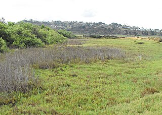
A salt marsh, saltmarsh or salting, also known as a coastal salt marsh or a tidal marsh, is a coastal ecosystem in the upper coastal intertidal zone between land and open saltwater or brackish water that is regularly flooded by the tides. It is dominated by dense stands of salt-tolerant plants such as herbs, grasses, or low shrubs. These plants are terrestrial in origin and are essential to the stability of the salt marsh in trapping and binding sediments. Salt marshes play a large role in the aquatic food web and the delivery of nutrients to coastal waters. They also support terrestrial animals and provide coastal protection.

Narragansett Bay is a bay and estuary on the north side of Rhode Island Sound covering 147 square miles (380 km2), 120.5 square miles (312 km2) of which is in Rhode Island. The bay forms New England's largest estuary, which functions as an expansive natural harbor and includes a small archipelago. Small parts of the bay extend into Massachusetts.

Mudflats or mud flats, also known as tidal flats or, in Ireland, slob or slobs, are coastal wetlands that form in intertidal areas where sediments have been deposited by tides or rivers. A global analysis published in 2019 suggested that tidal flat ecosystems are as extensive globally as mangroves, covering at least 127,921 km2 (49,391 sq mi) of the Earth's surface. They are found in sheltered areas such as bays, bayous, lagoons, and estuaries; they are also seen in freshwater lakes and salty lakes alike, wherein many rivers and creeks end. Mudflats may be viewed geologically as exposed layers of bay mud, resulting from deposition of estuarine silts, clays and aquatic animal detritus. Most of the sediment within a mudflat is within the intertidal zone, and thus the flat is submerged and exposed approximately twice daily.

Coos Bay is an estuary where the Coos River enters the Pacific Ocean, the estuary is approximately 12 miles long and up to two miles wide. It is the largest estuary completely within Oregon state lines. The Coos Bay watershed covers an area of about 600 square miles and is located in northern Coos County, Oregon, in the United States. The Coos River, which begins in the Oregon Coast Range, enters the bay from the east. From Coos River, the bay forms a sharp loop northward before arching back to the south and out to the Pacific Ocean. Haynes Inlet enters the top of this loop. South Slough branches off from the bay directly before its entrance into the Pacific Ocean. The bay was formed when sea levels rose over 20,000 years ago at the end of the Last Glacial Maximum, flooding the mouth of the Coos River. Coos Bay is Oregon's most important coastal industrial center and international shipping port, with close ties to San Francisco, the Columbia River, Puget Sound and other major ports of the Pacific rim.

A tidal creek or tidal channel is a narrow inlet or estuary that is affected by the ebb and flow of ocean tides. Thus, it has variable salinity and electrical conductivity over the tidal cycle, and flushes salts from inland soils. Tidal creeks are characterized by slow water velocity, resulting in buildup of fine, organic sediment in wetlands. Creeks may often be a dry to muddy channel with little or no flow at low tide, but with significant depth of water at high tide. Due to the temporal variability of water quality parameters within the tidally influenced zone, there are unique biota associated with tidal creeks which are often specialised to such zones. Nutrients and organic matter are delivered downstream to habitats normally lacking these, while the creeks also provide access to inland habitat for salt-water organisms.

The Thames Estuary is where the River Thames meets the waters of the North Sea, in the south-east of Great Britain.

A tidal marsh is a marsh found along rivers, coasts and estuaries which floods and drains by the tidal movement of the adjacent estuary, sea or ocean. Tidal marshes experience many overlapping persistent cycles, including diurnal and semi-diurnal tides, day-night temperature fluctuations, spring-neap tides, seasonal vegetation growth and decay, upland runoff, decadal climate variations, and centennial to millennial trends in sea level and climate.
An aquatic ecosystem is an ecosystem found in and around a body of water, in contrast to land-based terrestrial ecosystems. Aquatic ecosystems contain communities of organisms—aquatic life—that are dependent on each other and on their environment. The two main types of aquatic ecosystems are marine ecosystems and freshwater ecosystems. Freshwater ecosystems may be lentic ; lotic ; and wetlands.

Intertidal ecology is the study of intertidal ecosystems, where organisms live between the low and high tide lines. At low tide, the intertidal is exposed whereas at high tide, the intertidal is underwater. Intertidal ecologists therefore study the interactions between intertidal organisms and their environment, as well as between different species of intertidal organisms within a particular intertidal community. The most important environmental and species interactions may vary based on the type of intertidal community being studied, the broadest of classifications being based on substrates—rocky shore and soft bottom communities.

Marine ecosystems are the largest of Earth's aquatic ecosystems and exist in waters that have a high salt content. These systems contrast with freshwater ecosystems, which have a lower salt content. Marine waters cover more than 70% of the surface of the Earth and account for more than 97% of Earth's water supply and 90% of habitable space on Earth. Seawater has an average salinity of 35 parts per thousand of water. Actual salinity varies among different marine ecosystems. Marine ecosystems can be divided into many zones depending upon water depth and shoreline features. The oceanic zone is the vast open part of the ocean where animals such as whales, sharks, and tuna live. The benthic zone consists of substrates below water where many invertebrates live. The intertidal zone is the area between high and low tides. Other near-shore (neritic) zones can include mudflats, seagrass meadows, mangroves, rocky intertidal systems, salt marshes, coral reefs, lagoons. In the deep water, hydrothermal vents may occur where chemosynthetic sulfur bacteria form the base of the food web.
Grazing marsh is a British Isles term for flat, marshy grassland in polders. It consists of large grass fields separated by fresh or brackish ditches, and is often important for its wildlife.
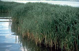
Brackish marshes develop from salt marshes where a significant freshwater influx dilutes the seawater to brackish levels of salinity. This commonly happens upstream from salt marshes by estuaries of coastal rivers or near the mouths of coastal rivers with heavy freshwater discharges in the conditions of low tidal ranges.
Salt pannes and pools are water retaining depressions located within salt and brackish marshes. Pools tend to retain water during the summer months between high tides, whereas pannes generally do not. Salt pannes generally start when a mat of organic debris is deposited upon existing vegetation, killing it. This creates a slight depression in the surrounding vegetation which retains water for varying periods of time. Upon successive cycles of inundation and evaporation the panne develops an increased salinity greater than that of the larger body of water. This increased salinity dictates the type of flora and fauna able to grow within the panne. Salt pools are also secondary formations, though the exact mechanism(s) of formation are not well understood; some have predicted they will increase in size and abundance in the future due to rising sea levels.

A marine habitat is a habitat that supports marine life. Marine life depends in some way on the saltwater that is in the sea. A habitat is an ecological or environmental area inhabited by one or more living species. The marine environment supports many kinds of these habitats.

Limoniastrum monopetalum, is a species of flowering plant in the family Plumbaginaceae that is native to between Europe, Northern Africa and Western Asia. It has been found in salt marshes, dunes and other coastal areas with high salinity levels. It has silver-grey or light green leaves on multi branching stems. At the ends of the stems are the summer blooming flowers, in shades of pink, purple, lavender and violet. It is known to be salt and drought tolerant, as well as having the ability to withstand some forms of soil pollution.

