Lucky Bay, South Australia

Last updated

Lucky Bay
South Australia
Luckybay-1.jpg
Lucky Bay Ferry Terminal
Australia South Australia location map.svg
Red pog.svg
Lucky Bay
Coordinates 33°42′11″S137°02′06″E / 33.703°S 137.035°E / -33.703; 137.035 Coordinates: 33°42′11″S137°02′06″E / 33.703°S 137.035°E / -33.703; 137.035
Population25 (2016 census) [1]
Established1998 [2]
Postcode(s) 5602
Time zone ACST (UTC+9:30)
 • Summer (DST) ACST (UTC+10:30)
Location198 km (123 mi) NW of Adelaide
LGA(s) District Council of Franklin Harbour [2]
Region Eyre Western [3]
County Jervois [2]
State electorate(s) Flinders [4]
Federal division(s) Grey [5]
Website Lucky Bay
Localities around Lucky Bay:
Mitchellville
Cowell Lucky Bay Spencer Gulf
Spencer Gulf Spencer Gulf

Lucky Bay is a locality in the District Council of Franklin Harbour, on the Spencer Gulf coast of Eyre Peninsula in South Australia. It is a terminus for SeaSA's Spencer Gulf passenger ferry and a transshipping port for grain export operated by T-Ports. Lucky Bay is located immediately north-east of the Franklin Harbour wetlands. Its adjacent waters lie within the outer boundary of the Franklin Harbor Marine Park. A ferry service crossing Spencer Gulf from Lucky Bay to Wallaroo commenced in 2006, and the dirt road connecting Lucky Bay with the Lincoln Highway was sealed in 2008. [6]

Contents

Residential and recreational use

A strip of coastal homes or 'shacks' extends along the coast to the north-east of the ferry terminal. [7] Several of these are available to rent. [8] Beach-launching boat access exists for residents and holiday-makers. The adjacent waters are popular among fishermen, with snapper being one of the region's prized catches. [9]

Spencer Gulf ferry

The development of a ferry terminal at Lucky Bay was approved by South Australian planning minister Paul Holloway in November 2005. The ferry service commenced in December 2006 and has been an economic boon to the nearby township of Cowell. [10]

The passenger ferry is operated by SeaSA Ltd and transports vehicles and passengers across Spencer Gulf between Lucky Bay and Wallaroo. The ferry service received an Australian Marine Environment Protection Association (AUSMEPA) award in 2006 "for its potential to save more than 25,000 tonnes of carbon emissions annually from road traffic by providing a cross-Gulf alternative to the lengthy round-Gulf car trip." [11]

During its first three years of operation, three different vessels provided the ferry service: MV Seaway, Sea Scape and Sea Spirit. In 2009, the service was suspended. [12]

From February 2012 until September 2014, a purpose-built vessel, the Aurora V, provided the ferry service. [13] It was then suspended to allow the expansion of the harbour's basin and substantial vegetation clearance and earthworks to commence. The ferry service resumed in October 2016 [14] using the vessel Sea Star. [12]

In August 2017, the ferry service was suspended again to allow for further construction works at Lucky Bay harbour. In 2019, SeaSA advised that their vessel, the Aurora V which had been sold to a Venezuelan then bought back again, [13] was stuck in Venezuela due to problems arising from political instability there. [15]

The ferry service resumed in November 2020 using the vessel Aurora V. The ship sails under the Spencer Gulf Searoad business name. [16] The ferry service was suspended in late June and is expected to resume in late July after maintenance work on the vessel undertaken at Port Adelaide. [17]

Harbour expansion

Between 2011 and 2018 various plans to expand the Lucky Bay passenger ferry terminal to facilitate new transshipment facilities were proposed and approved. The first of these was a proposal to accommodate shipments of iron ore, followed by a plan to export wheat in 2016. The Australian Government contributed $2.2 million to the project [18] via the Regional Development Australia's Regional Development Fund.

Under the SA Government's Eyre Peninsula Grain Growers Rail Fund, Sea Transport Developments SA Pty Ltd received a $90,000 grant to undertake a range of site design and related assessments for a handling facility for the export of grain. [19]

By October 2016, $20 million had been spent on harbour expansion works, and the basin's depth had been increased to 5.5 metres LAT. [20]

Iron ore export plan

In April 2011 a proposal to export iron ore from Lucky Bay received Crown-sponsored development status from the Government of South Australia, under Section 49 of the state's Development Act 1993. As a result, development proposal documentation was withdrawn from the general public after a three-week open period calling for submissions. [21]

One of the responsible parties, Ironclad Mining had previously sought government approval to haul ore from Wilcherry Hill via road to a rail siding at Lincoln Gap near Whyalla. From there it was to be transported to Port Adelaide by rail, then loaded onto ships using existing infrastructure there. This export corridor was approved by the Federal government on 23 September 2011, under the Environment Protection Biodiversity Conservation (EPBC) Act. [22] A week later, Ironclad Mining lodged a formal Development Application to expand the existing ferry terminal at Lucky Bay and export iron ore from there.

On 5 April 2012, the Lucky Bay proposal was approved by Robert Kleeman, acting as a delegate for the South Australian Minister for Planning. The project's proponents continued to refine the design of the facility, and lodged several amendments to the proposal the following year, including plans to add a buffer storage facility (iron ore stockpiles) and relocate transshipping points closer to shore.

On 3 December 2013, the revised proposal which included multiple cost-saving variations received State Government development approval. [23] The project involved the following entities: SeaSA, Masterplan, Ironclad Mining Ltd and the District Council of Franklin Harbour. While the project claimed to offer a Common User Export Facility, there was one named future user of the port at the time: Ironclad Mining Ltd.

Ironclad Mining claimed that delays associated with project amendments and approvals cost the company approximately $6 million. [24] The iron ore export proposal did not proceed.

Wheat export plan

A change of direction for the project saw the emergence of Free Eyre Ltd's interest in exporting grain from Lucky Bay. The group expected the facility would be ready to transship grain by the 2015 harvest, but this did not eventuate. [25]

In early 2016, a formal proposal to construct facilities to support the transshipment of wheat was considered and approved by the Development Assessment Commission.

In July 2016, the port's owners, Spencer Gulf Trust, announced that it expected the new facilities to be operable for the 2017 harvest. [20] [26]

In May 2017, The Advertiser reported that a consortium which includes Inheritance Capital Asset Management (ICAM) and Duxton Capital was raising investment in the port development. Rob Chapman and commodities expert Ed Peter are part of the consortium. [27] In 2018, the company T-Ports was established with four founding shareholders: ACIF, ICAM, Duxton Asset Management and Sea Transport. [28]

By March 2018, outer channel dredging works had been approved and the project timeline had been revised. The harbour was expected to be ready to export grain following the 2018 harvest. [29] The proposed construction included storage at Lucky Bay for 430,000 tonnes of grain and an additional 150,000 tonnes at Lock. The grain will be transferred to a custom-built trans-ship to carry it out to larger ships in deeper water. [30]

The new process is expected to be capable of loading a Panamax vessel in 3 days. [20] The purpose-built MV Lucky Eyre arrived in March 2020 to serve as the transshipment vessel. Its owners consider it a "world first" vessel as it provides a self-propelled, self-discharging transhipment solution. [31] The larger ships will be anchored 5 nautical miles (9.3 km; 5.8 mi) offshore. The transfer ship is 87 metres (285 ft) long and can transfer up to 13,800 tonnes per day. It will undergo a three-stage commissioning process before entering service. [32]

Commissioning (2019-2020)

The first load of wheat arrived at the storage facility at Lucky Bay in October 2019 [33] and the purpose-built MV Lucky Eyre arrived from China in late March 2020 for dry and wet commissioning. [34] The vessel has a reported draft of 4.2 metres, travels at an average speed of 7.2 knots [35] and can carry a cargo of 3,300 tonnes of grain. Sea Transport claims that the vessel is capable of loading 10,800 to 13,250 tonnes of grain per day in "good weather". [36]

The Maritime Union of Australia has unsuccessfully attempted to meet with T-Ports to discuss concerns they have over the operation's compliance and safety given the exposed nature of the transshipping location within Spencer Gulf. [37]

On March 31, the bulk carrier Wave Friend was being loaded at the transshipping point directly south of Lucky Bay within the Franklin Harbor Marine Park. [38] She has a draft of 8.1 metres and a carrying capacity of 28368 DWT. [39]

The port was officially opened in April 2020 [40] and was expected to make its first exports in summer 2020-21. The proponents of the project, T-Ports Pty Ltd are represented to the South Australian parliament by lobbyist and former politician, Christopher Pyne, though his firm Pyne and Partners. [41] The silos that store the grain near the waterfront were manufactured in South Australia by Ahrens. [42]

In December 2021, the project's owner ICAM Duxton Port Infrastructure Trust (IDPIT) announced it would received $40 million in a refinancing deal with Merricks Capital. [43]

Environment

The region is adjacent to the Franklin Harbour wetlands, and two tidal creeks bracket the shack settlement and recently developed grain-loading facilities. The sand flats, dunes and beaches are home to or visited by many threatened species, including various migratory waders, the banded stilt, hooded plover and white-bellied sea eagle. [44] The white-bellied sea eagle is listed as endangered in South Australia, under the state's National Parks and Wildlife Act 1972 . The banded stilt and hooded plover are both listed as vulnerable under the same act. [45]

In 2011, the Eyre Peninsula Coastal Action Plan recommended that coastal flora and fauna surveys be conducted from Lucky Bay eastward to Shoalwater Point in order 'to inform future management directions'. This recommendation was in response to 'very inadequate data on biodiversity and habitat values'. It was flagged as a 'high priority' action to undertake. [46]

Franklin Harbor Marine Park

Lucky Bay lies within the State-managed Franklin Harbor Marine Park. The park was established in 2009 to protect habitat for the weedy seadragon which is also fully protected under the State's Fisheries Management Act. It is also home to blue swimmer crabs, prawns, King George whiting, sardines and several other commercially important scalefish species. [47] Fishing is permitted within the Franklin Harbor Marine Park's outer boundary, but is prohibited within several Sanctuary Zones. [48] Two Special Purpose Areas exist within the park to allow for the transshipment of bulk commodities between vessels. [49]

Environmental threats

Development is considered one of several threats to this area, including what was described in 2011 as "a proposed major development that is likely to impact on coastal landforms, habitats and vegetation, as well as increase the visitation, threats and pressure on the coastal areas within the cell if it goes ahead". [46] Environmentalists are concerned that the sound and dust pollution from proposed iron ore exports could disturb birds' established feeding behaviors and roosts. [50]

Related Research Articles

Whyalla City in South Australia

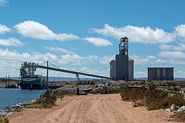
Whyalla was founded as "Hummocks Hill", and was known by that name until 1916. It is the fourth most populous city in the Australian state of South Australia after Adelaide, Mount Gambier and Gawler and along with Port Pirie and Port Augusta is one of the three towns to make up the Iron Triangle. As at June 2018, Whyalla had an urban population of 21,742, having declined at an average annual rate of -0.75% year-on-year over the preceding five years. It is a seaport located on the east coast of the Eyre Peninsula and is known as the "Steel City" due to its integrated steelworks and shipbuilding heritage. The port of Whyalla has been exporting iron ore since 1903.

Spencer Gulf Large inlet in South Australia between the Eyre Peninsula and the Yorke Peninsula

The Spencer Gulf is the westernmost and larger of two large inlets on the southern coast of Australia, in the state of South Australia, facing the Great Australian Bight. It spans from the Cape Catastrophe and Eyre Peninsula in the west to Cape Spencer and Yorke Peninsula in the east.

Port Lincoln City in South Australia

Port Lincoln is a town on the Lower Eyre Peninsula in the Australian state of South Australia. It is situated on the shore of Boston Bay, which opens eastward into Spencer Gulf. It is the largest city in the West Coast region, and is located approximately 280 km as the crow flies from the State's capital city of Adelaide. In June 2019 Port Lincoln had an estimated population of 16,418, having grown at an average annual rate of 0.55% year-on-year over the preceding five years. The city is reputed to have the most millionaires per capita in Australia, as well as claiming to be Australia's "Seafood Capital".

Yorke Peninsula Region in South Australia

The Yorke Peninsula is a peninsula located north-west and west of Adelaide in South Australia, between Spencer Gulf on the west and Gulf St Vincent on the east. The peninsula is separated from Kangaroo Island to the south by Investigator Strait. The most populous town in the region is Kadina.

Eyre Peninsula South Australia

The Eyre Peninsula is a triangular peninsula in South Australia. It is bounded on the east by Spencer Gulf, the west by the Great Australian Bight, and the north by the Gawler Ranges.

Wallaroo, South Australia Town in South Australia

Wallaroo is a port town on the western side of Yorke Peninsula in South Australia, 160 kilometres (100 mi) northwest of Adelaide. It is one of the three Copper Triangle towns famed for their historic shared copper mining industry, and known together as "Little Cornwall", the other two being Kadina, about 8 kilometres (5 mi) to the east, and Moonta, about 18 kilometres (11 mi) south. In 2016, Wallaroo had a population of 3,988 according to the census held.

Cummins, South Australia Town in South Australia

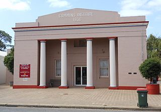
Cummins is a town on Eyre Peninsula in South Australia, 67 km north of Port Lincoln and 60 m above sea level. At the 2011 census, the town had a population of 719.

Tumby Bay, South Australia Town in South Australia

Tumby Bay is a coastal town situated on the Spencer Gulf, on the eastern coast of Eyre Peninsula in South Australia, 45 kilometres (28 mi) north of Port Lincoln. The town of Tumby Bay is the major population centre of the District Council of Tumby Bay, and the centre of an agricultural district farming cereal crops and sheep, as well as having established fishing and tourism industries.

Cowell, South Australia Town in South Australia

Cowell is a coastal town on Franklin Harbor on the eastern side of the Eyre Peninsula, in South Australia on the Lincoln Highway 111 km south of the major town of Whyalla. It is 493 km by road from Adelaide.

District Council of Franklin Harbour Local government area in South Australia

The District Council of Franklin Harbour is a local government area in South Australia on the Eyre Peninsula. Cowell is the major population centre of an agricultural district based on farming wheat and sheep, supplemented by a fishing and oyster farming industries. The district's coastal towns including Cowell and Lucky Bay attract large numbers of tourists during school holidays, with the new Spencer Gulf ferry service increasing traffic to these areas since 2006.

Port Bonython Suburb of City of Whyalla, South Australia

Port Bonython is the location of a deepwater port, gas fractionation plant and diesel storage facility west of Point Lowly in the Upper Spencer Gulf region of South Australia. It lies 16 km east-northeast of Whyalla, South Australia and approximately 370 km north-west of the State's capital city, Adelaide. The existing wharf is 2.4 kilometres long and is capable of berthing small Capesize ships with a maximum capacity of 110,000 tonnes. The wharf was established in 1982 and named after John Bonython, the founding chairman of Santos. The structure is leased to Santos by the Government of South Australia and is used for the export of hydrocarbon products. An oil spill at Port Bonython in 1992 resulted in loss of bird life and damage to mangrove habitats to the west and southwest of Port Pirie.

Port Spencer South Australia

Port Spencer is a proposed grain export port development project in South Australia. The project site, previously known as Sheep Hill, is on Lower Eyre Peninsula adjacent to Lipson Cove on the western shore of Spencer Gulf.

Lipson Cove

Lipson Cove is a tranquil sandy bay in the Australian state of South Australia on the east coast of Eyre Peninsula overlooking Spencer Gulf. It features in the 2012 book 101 Best Australian Beaches by Andy Short and Brad Farmer.

The Wilcherry Hill Project was originally a proposed iron ore mine and associated infrastructure on Eyre Peninsula, South Australia. It was proposed by Ironclad Mining Ltd which later merged with Trafford Resources to become Tyranna Resources. As of 2018, the Wilcherry Project is a joint venture between Alliance Resources (67.35%) and Tyranna Resources (32.65%). The venture is exploring for economic concentrations of any of gold, tin, copper, zinc, lead, silver, iron, bismuth, tungsten and uranium.

Iron Road Limited Australian company intending to mine and concentrate magnetite and develop a deep-water port on Eyre Peninsula, South Australia

Iron Road Ltd is an Australian iron ore exploration and mining company, listed on the Australian Securities Exchange in Perth, Western Australia since 2008 with an objective to develop a world class magnetite mine and infrastructure in South Australia. Its two projects were the Central Eyre Iron Project (CEIP), the planned output of which was to be 24 million tonnes per annum of approximately 67 per cent iron concentrate for almost 30 years; and the Gawler Iron Project, in abeyance as of 2021. The company's corporate office is in Adelaide.

Cape Hardy South Australia

Cape Hardy is a 20 m (66 ft) high, dune-capped granite headland on the eastern coast of Eyre Peninsula and which protrudes into Spencer Gulf in South Australia. It is located between the towns of Port Neill and Tumby Bay, 10 km (6.2 mi) north-northeast of Lipson Cove.

Transport in South Australia is provided by a mix of road, rail, sea and air transport. The capital city of Adelaide is the centre to transport in the state. With its population of 1.4 million people, it has the majority of the state's 1.7 million inhabitants. Adelaide has the state's major airport and sea port.

Port Gibbon, South Australia Suburb of District Council of Franklin Harbour, South Australia

Port Gibbon is a locality in the Australian state of South Australia located on the east coast of Eyre Peninsula about 208 kilometres north-west of the state capital of Adelaide and about 17 kilometres south-west of the municipal seat in Cowell.

Franklin Harbor Marine Park Protected area in South Australia

Franklin Harbor Marine Park is a marine park in Spencer Gulf in South Australia. It is adjacent and overlapping with Franklin Harbor Conservation Park.

Free Eyre Ltd is an agribusiness based on Eyre Peninsula, South Australia. The company's objectives include exploring and partnering in ventures designed to reduce costs across the supply chain. The company was formed after drought during the 2000s caused hardship to many of the region's growers. It is an unlisted Australian public company whose 475 shareholders represent over half of Eyre Peninsula's farming families. It was incorporated in 2007.

References

  1. Australian Bureau of Statistics (27 June 2017). "Lucky Bay". 2016 Census QuickStats. Retrieved 2 April 2020. OOjs UI icon edit-ltr-progressive.svg
  2. 1 2 3 "Search result for "Lucky Bay (Locality Bounded)" (Record no SA0041636) with the following layers being selected - "Suburbs and Localities", "Local Government Areas", "Development Plan Layers", "Place names (gazetteer)" and "Hundreds"". Property Location Browser. Government of South Australia. Archived from the original on 12 October 2016. Retrieved 11 April 2017.
  3. "Eyre Western SA Government region" (PDF). The Government of South Australia. Retrieved 10 October 2014.
  4. "District of Flinders Background Profile". Electoral Commission SA. Retrieved 9 September 2015.
  5. "Federal electoral division of Grey" (PDF). Australian Electoral Commission. Retrieved 24 July 2015.
  6. "General sponsor - SeaSA" (PDF). SeaSA. Retrieved 23 August 2015.[ permanent dead link ]
  7. "Lucky Bay Shack Extension?". Eyre Peninsula Tribune . 6 June 2013. Retrieved 8 December 2013.
  8. "Accommodation". District Council of Franklin Harbour . Retrieved 18 March 2020.
  9. "Snapper caught at Lucky Bay". Seasagetaways.com.au. Archived from the original on 6 December 2013. Retrieved 3 December 2013.
  10. Henderson, Tom (9 February 2009). "Ferry Lucky Bay". ABC North & West SA. Retrieved 8 December 2013.
  11. "SeaSA Pty Ltd > About Us". SeaSA car & passenger Ferry. Archived from the original on 17 October 2015. Retrieved 8 December 2013.
  12. 1 2 Hamilton, Jodie; Culliver, Paul; Jeanes, Tim (13 April 2019). "Venezuelan political crisis halts SA's Lucky Bay-to-Wallaroo ferry service". ABC News. Retrieved 31 March 2020.
  13. 1 2 Sutton, Malcolm (31 October 2019). "Cruise ship welcomed by Copper Coast locals but where's the Lucky Bay ferry?". ABC News. Retrieved 31 March 2020.
  14. "New ferry start date". Eyre Peninsula Tribune . 29 August 2016. Retrieved 16 December 2016.
  15. "Lucky Bay Shoreside Facility Construction Suspends Sea SA Ferry Service". seasa.com.au. Retrieved 31 March 2020.
  16. Koch, Rhiannon. "Yorke Peninsula Country Times - Ferry service back in operation at last". www.ypct.com.au. Retrieved 20 November 2020.
  17. "Ferry goes to slip for maintenance". Port Lincoln Times. 18 June 2021. Retrieved 18 June 2021.
  18. Development, Minister for Infrastructure and Regional. "Export shipping set to surge at Lucky Bay facility". Minister for Infrastructure and Regional Development. Retrieved 21 December 2016.
  19. Australia, Department of Primary Industries and Regions, South. "Eyre Peninsula Grain Growers Rail Fund". pir.sa.gov.au. Retrieved 22 March 2018.
  20. 1 2 3 "Free Eyre announces port venture". Stock Journal. 28 October 2016. Retrieved 6 October 2018.
  21. "SA govt sponsors port approval" Myresources.com.au (retrieved 2013-12-03)
  22. Australian Government, Department of Environment "Referral detail - Ironclad Mining Limited /Mining/Uno Pastoral Station, Northern Erye Peninsula/SA/Wilcherry Hill Project" (Retrieved 2013-12-03)
  23. "IronClad Mining's Lucky Bay export port gains state development approval" ABC News (2013-12-03)
  24. "Lucky Bay miner counts cost of export facility delays" ABC News (2013-11-04)
  25. User, Super. "Free Eyre". www.free-eyre.com.au. Retrieved 22 March 2018.
  26. "Grain transhipping system heads to Eyre Peninsula". ABC Rural. 15 July 2016. Retrieved 21 December 2016.
  27. England, Cameron (26 May 2017). "Crows chairman Rob Chapman behind consortium build to build $100 million port on Eyre Peninsula". www.adelaidenow.com.au. Retrieved 17 October 2017.
  28. "About | T-Ports". tports.com. Retrieved 4 April 2020.
  29. "Lucky Bay port due in 2018". Port Lincoln Times. 14 March 2018. Retrieved 22 March 2018.
  30. Neindorf, Brooke (14 March 2018). "New Lucky Bay shallow harbour a game-changer for grain growers". ABC Rural . ABC News . Retrieved 7 April 2018.
  31. Fogden, Alisha (25 July 2019). "Lucky Bay port ready for receivals". Stock Journal. Retrieved 31 March 2020.
  32. Spence, Andrew (17 March 2020). "Regional SA port shipshape for grain exports". InDaily . Retrieved 18 March 2020.
  33. "T-Ports receives first load of grain into Lucky Bay bunker site | T-Ports" . Retrieved 31 March 2020.
  34. "Long-awaited vessel arrives at Lucky Bay". West Coast Sentinel. 31 March 2020. Retrieved 31 March 2020.
  35. "MV Lucky Eyre". www.marinetraffic.com. Retrieved 31 March 2020.
  36. Solutions, Sea Transport (21 May 2018). "Brand New Transhipment Vessel for Farmers at Lucky Bay Grain Port". Naval Architects, Consultants & Surveyors. Retrieved 31 March 2020.
  37. "T Ports - MV Lucky Eyre - Lucky Bay". Maritime Union of Australia. Retrieved 31 March 2020.
  38. "MarineTraffic: Global Ship Tracking Intelligence | AIS Marine Traffic". www.marinetraffic.com. Retrieved 31 March 2020.
  39. "Wave Friend". www.marinetraffic.com. Retrieved 31 March 2020.
  40. "Port in shipshape for first Australian grain exports". Hellenic Shipping News Worldwide. Retrieved 31 March 2020.
  41. "Lobbyist Portal". www.lobbyists.sa.gov.au. Retrieved 14 June 2021.
  42. Alexandra Cooper (23 September 2021). "Continuously innovating silo manufacturing plant best in its field". Manufacturers' Monthly. Retrieved 24 September 2021.
  43. Heard, Gregor (17 December 2021). "T-Ports Lucky Bay attracts refinance capital". Queensland Country Life. Retrieved 18 December 2021.
  44. "Explore Your Area - Lucky Bay, SA" Atlas of Living Australia (Retrieved 2013-12-03)
  45. National Parks and Wildlife Act (No 56 of 1972) (SA)
  46. 1 2 "Cell descriptions – EP9 Shoalwater Point" (PDF). Eyre Peninsula Coastal Action Plan & Conservation Priority Study. Government of South Australia - Eyre Peninsula Natural Resource Management Board. 2011. Archived from the original (PDF) on 22 February 2014.
  47. "Franklin Harbor Marine Park". SA Department of Environment, Water & Natural Resources. Retrieved 8 December 2013.
  48. "Franklin Harbor Marine Park Management Plan 2012" (PDF). SA Department of Environment, Water & Natural Resources. Retrieved 8 December 2013.
  49. "Franklin Harbor Marine Park Management plan summary" (PDF). Department of Environment, Water and Natural Resources, Government of South Australia. December 2012. Retrieved 2 April 2020.
  50. "Export port plan sparks fear for rare bird" ABC News (2013-12-04)