Midgee, South Australia

Last updated

Midgee
South Australia
Australia South Australia location map.svg
Red pog.svg
Midgee
Coordinates 33°25′15″S137°09′16″E / 33.42093580°S 137.15457634°E / -33.42093580; 137.15457634 Coordinates: 33°25′15″S137°09′16″E / 33.42093580°S 137.15457634°E / -33.42093580; 137.15457634
Population 299 (shared with other localities in the “State Suburb of Point Lowly”) (2011 census) [1]
Established 1998 [2]
Postcode(s) 5602 [3]
Time zone ACST (UTC+9:30)
 • Summer (DST) ACST (UTC+10:30)
Location
  • 214 km (133 mi) north-west of Adelaide
  • 37 km (23 mi) north of Cowell
LGA(s) District Council of Franklin Harbour [2]
Region Eyre Western [4]
County Jervois [2]
State electorate(s) Flinders [5]
Federal Division(s) Grey [6]
Mean max tempMean min tempAnnual rainfall
23.7 °C
75 °F
11.5 °C
53 °F
267.2 mm
10.5 in
Suburbs around Midgee:
Middleback Range Middleback Range
Murninnie Beach
Spencer Gulf
Minbrie Midgee Spencer Gulf
Minbrie Mitchellville Spencer Gulf
Footnotes Distances [3]
Coordinates [2]
Climate [7]
Adjoining suburbs [2]

Midgee is a locality in the Australian state of South Australia located on the east coast of Eyre Peninsula about 214 kilometres (133 miles) north-west of the state capital of Adelaide and about 37 kilometres (23 miles) north of the municipal seat of Cowell. [3]

South Australia State of Australia

South Australia is a state in the southern central part of Australia. It covers some of the most arid parts of the country. With a total land area of 983,482 square kilometres (379,725 sq mi), it is the fourth-largest of Australia's states and territories by area, and fifth largest by population. It has a total of 1.7 million people, and its population is the second most highly centralised in Australia, after Western Australia, with more than 77 percent of South Australians living in the capital, Adelaide, or its environs. Other population centres in the state are relatively small; Mount Gambier, the second largest centre, has a population of 28,684.

Eyre Peninsula South Australia

The Eyre Peninsula is a triangular peninsula in South Australia. It is bounded on the east by Spencer Gulf, the west by the Great Australian Bight, and the north by the Gawler Ranges.

Adelaide city centre Suburb of Adelaide, South Australia

Adelaide city centre is the innermost locality of Greater Adelaide, the capital city of South Australia. It is known by locals simply as "The City" or "Town" to distinguish it from Greater Adelaide and from the City of Adelaide. The locality is split into two key geographical distinctions: the city "square mile", bordered by North, East, South and West Terraces; and the section of the parklands south of the River Torrens which separates the built up part of the city from the surrounding suburbs and North Adelaide.

Its boundaries were created in 1998 in respect to the “long established local name.” [2] [8]

Land use in Midgee is divided between primary industry and conservation with the former being represented by “broadacre farming of cereals and livestock” and the latter being represented by the Munyaroo Conservation Park and the zoning of land adjoining the coastline with Spencer Gulf. [9] [2]

Conservation (ethic) ethic of resource use, allocation, and protection

Conservation is an ethic of resource use, allocation, and protection. Its primary focus is upon maintaining the health of the natural world, its fisheries, habitats, and biological diversity. Secondary focus is on material conservation, including non-renewable resources such as metals, minerals and fossil fuels, and energy conservation, which is important to protect the natural world. Those who follow the conservation ethic and, especially, those who advocate or work toward conservation goals are termed conservationists.

Munyaroo Conservation Park Protected area in South Australia

Munyaroo Conservation Park is a protected area in the Australian state of South Australia in the gazetted locality of Midgee located on the east coast of the Eyre Peninsula about 36 kilometres south south-west of Whyalla and 35 kilometres east north-east of Cowell.
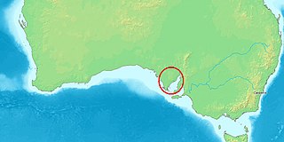
Spencer Gulf A large inlet in South Australia between the Eyre Peninsula and the Yorke Peninsula

The Spencer Gulf is the westernmost of two large inlets on the southern coast of Australia, in the state of South Australia, facing the Great Australian Bight. It spans from the Cape Catastrophe and Eyre Peninsula in the west to Cape Spencer and Yorke Peninsula in the east.

Midgee is located within the federal division of Grey, the state electoral district of Flinders and the local government area of the District Council of Franklin Harbour. [6] [5] [2]

Division of Grey Australian federal electoral division

The Division of Grey is an Australian electoral division in South Australia. The division was one of the seven established when the former Division of South Australia was redistributed on 2 October 1903 and is named for Sir George Grey, who was Governor of South Australia from 1841 to 1845.

Electoral district of Flinders state electoral district of South Australia

Flinders is a single-member electoral district for the South Australian House of Assembly. It is named after explorer Matthew Flinders, who was responsible for charting most of the state's coastline. It is a 58,901 km² coastal rural electorate encompassing the Eyre Peninsula and the coast along the Nullarbor Plain, based in and around the city of Port Lincoln and contains the District Councils of Ceduna, Cleve, Elliston, Lower Eyre Peninsula, Streaky Bay and Wudinna; as well as the localities of Fowlers Bay, Nullarbor and Yalata in the Pastoral Unincorporated Area. The seat was expanded in 2002 to include a western strip of land all the way to the Western Australia border.

District Council of Franklin Harbour Local government area in South Australia

The District Council of Franklin Harbour is a local government area in South Australia on the Eyre Peninsula. Cowell is the major population centre of an agricultural district based on farming wheat and sheep, supplemented by a fishing and oyster farming industries. The district's coastal towns including Cowell and Lucky Bay attract large numbers of tourists during school holidays, with the new Spencer Gulf ferry service increasing traffic to these areas since 2006.

See also

Related Research Articles

Buckleboo Town in South Australia

Buckleboo is a locality in the Australian state of South Australia on the Eyre Peninsula located about 313 kilometres (194 mi) northwest of the state capital of Adelaide and about 31 kilometres (19 mi) northwest of the municipal seat of Kimba. It is in the local government area of the District Council of Kimba, the state electoral district of Flinders and the federal division of Grey.

Wanilla, South Australia Suburb of District Council of Lower Eyre Peninsula, South Australia


Wanilla is a locality in the Australian state of South Australia located on the southern end of Eyre Peninsula about 271 kilometres (168 mi) west of the state capital of Adelaide and about 25 kilometres (16 mi) north-west of the city of Port Lincoln.

Calca, South Australia Town in South Australia

Calca is a small township around 20 kilometres (12 mi) south-east of Streaky Bay, on the southern border of the Calpatanna Waterhole Conservation Park, Eyre Peninsula.

Tooligie, South Australia Town in South Australia

Tooligie is a small town in South Australia on the Eyre Peninsula about 290 kilometres west of the Adelaide city centre and about 84 kilometres north of the city of Port Lincoln.

Moody, South Australia Suburb of District Council of Tumby Bay, South Australia

Moody is a locality in the Australian state of South Australia located on the Eyre Peninsula about 257 kilometres west of the state capital of Adelaide. Its name and boundaries were both adopted and created in 1978. Its name is derived from the Hundred of Moody, the cadastral unit in which it is located. Moody is located within the federal division of Grey, the state electoral district of Flinders and the local government area of the District Council of Tumby Bay.

Hincks, South Australia Suburb of District Council of Cleve, District Council of Tumby Bay, South Australia

Hincks is a locality in the Australian state of South Australia located on the Eyre Peninsula about 253 kilometres west of the state capital of Adelaide.

Lincoln National Park, South Australia Suburb of District Council of Lower Eyre Peninsula, South Australia

Lincoln National Park is a locality located on the Jussieu Peninsula at the southern tip of the Eyre Peninsula in the Australian state of South Australia about 250 kilometres west of the state capital of Adelaide and about 13 kilometres south of the city of Port Lincoln.

Tulka, South Australia Suburb of District Council of Lower Eyre Peninsula, South Australia

Tulka is a locality in the Australian state of South Australia located on the southern tip of Eyre Peninsula overlooking the western end of the body of water known as Port Lincoln and which is located 259 kilometres west of the state capital of Adelaide and about 10 kilometres west of the city of Port Lincoln.

Bookabie, South Australia Suburb of Pastoral Unincorporated Area, South Australia

Bookabie is a town and locality in the Australian state of South Australia located on the state’s west coast overlooking the Great Australian Bight about 648 kilometres north-west of the state capital of Adelaide and about 103 kilometres west of the town centre of Ceduna.

Colton, South Australia Suburb of District Council of Elliston , South Australia

Colton is a locality in the Australian state of South Australia located on the west coast of Eyre Peninsula overlooking the Great Australian Bight about 374 kilometres (232 mi) north-west of the state capital of Adelaide and about 19 kilometres (12 mi) north of the municipal seat of Elliston.

Pureba, South Australia Suburb of District Council of Ceduna, South Australia

Pureba is a locality in the Australian state of South Australia located on the west coast of Eyre Peninsula and on land to the immediate north of the peninsula about 528 kilometres north-west of the state capital of Adelaide and about 52 kilometres north-east and 90 kilometres north respectively of the municipal seats of Ceduna and Streaky Bay.

Mitchellville, South Australia Suburb of District Council of Franklin Harbour, South Australia

Mitchellville is a locality in the Australian state of South Australia located on the east coast of Eyre Peninsula about 198 kilometres north-west of the state capital of Adelaide and about 23 kilometres north of the municipal seat of Cowell.

Port Gibbon, South Australia Suburb of District Council of Franklin Harbour, South Australia

Port Gibbon is a locality in the Australian state of South Australia located on the east coast of Eyre Peninsula about 208 kilometres north-west of the state capital of Adelaide and about 17 kilometres south-west of the municipal seat in Cowell.

Uley, South Australia Suburb of District Council of Lower Eyre Peninsula , South Australia

Uley is a locality in the Australian state of South Australia located at the southern tip of the Eyre Peninsula overlooking the body of water known as the Great Australian Bight about 273 kilometres (170 mi) west of the state capital of Adelaide and about 22 kilometres (14 mi) west of the city of Port Lincoln.

Farm Beach, South Australia Suburb of District Council of Lower Eyre Peninsula, South Australia

Farm Beach is a locality in the Australian state of South Australia located on the Eyre Peninsula in the state’s west overlooking the body of water known as Coffin Bay about 297 kilometres (185 mi) west of the state capital of Adelaide and about 40 kilometres (25 mi) south-west of the municipal seat of Cummins.

Little Douglas, South Australia Suburb of District Council of Lower Eyre Peninsula, South Australia

Little Douglas is a locality in the Australian state of South Australia located on the Eyre Peninsula in the state’s west overlooking the body of water known as Coffin Bay about 293 kilometres (182 mi) west of the state capital of Adelaide and about 42 kilometres (26 mi) south-west of the municipal seat of Cummins.

Kellidie Bay, South Australia Suburb of District Council of Lower Eyre Peninsula, South Australia

Kellidie Bay is a locality in the Australian state of South Australia located on the Eyre Peninsula in the state’s west overlooking parts of the body of water known as Coffin Bay about 290 kilometres (180 mi) west of the state capital of Adelaide and about 42 kilometres (26 mi) south-west of the municipal seat of Cummins.

Duck Ponds, South Australia Suburb of District Council of Lower Eyre Peninsula, South Australia

Duck Ponds is a locality in the Australian state of South Australia located on the Eyre Peninsula in the state’s west about 258 kilometres (160 mi) west of the state capital of Adelaide, about 51 kilometres (32 mi) south of the municipal seat of Cummins and about 6 kilometres (3.7 mi) west of the city of Port Lincoln.

Eba Anchorage, South Australia Suburb of District Council of Streaky Bay, South Australia

Eba Anchorage is a locality in the Australian state of South Australia located in the state's west on the eastern shore of Streaky Bay on the west coast of the Eyre Peninsula about 469 kilometres (291 mi) north-west of the state capital of Adelaide and about 14 kilometres (8.7 mi) north-east of the municipal seat of Streaky Bay.

Brooker, South Australia Suburb of District Council of Tumby Bay, South Australia

Brooker is a locality in the Australian state of South Australia located in the state’s west on Eyre Peninsula about 266 kilometres (165 mi) west of the state capital of Adelaide and about 38 kilometres (24 mi) north-west of the municipal seat in Tumby Bay.

References

  1. Australian Bureau of Statistics (31 October 2012). "Point Lowly". 2011 Census QuickStats. Retrieved 9 April 2017. Blue pencil.svg
  2. 1 2 3 4 5 6 7 8 "Search result for "Midgee (Locality Bounded)" (Record no SA0044664) with the following layers being selected - "Suburbs and Localities", "Local Government Areas" and "Hundreds"". Property Location Browser. Government of South Australia. Archived from the original on 12 October 2016. Retrieved 9 April 2017.
  3. 1 2 3 "Midgee, South Australia (Postcode)". postcodes-australia.com. Retrieved 9 April 2017.</}}
  4. "Eyre Western SA Government region" (PDF). The Government of South Australia. Retrieved 10 October 2014.
  5. 1 2 "District of Flinders Background Profile". Electoral Commission SA. Retrieved 9 September 2015.
  6. 1 2 "Federal electoral division of Grey" (PDF). Australian Electoral Commission. Retrieved 24 July 2015.
  7. "Monthly climate statistics: Summary statistics WHYALLA AERO". Commonwealth of Australia , Bureau of Meteorology. Retrieved 7 April 2017.
  8. "GEOGRAPHICAL NAMES ACT 1991, Notice to Assign Boundaries and Names to Places" (PDF). The South Australian Government Gazette. Government of South Australia: 2009. 23 December 1998. Retrieved 9 April 2017.
  9. "Development Plan, Franklin Harbour Council, Consolidated – 11 February 2016" (PDF). Government of South Australia. 2016. pp. 9, 181, 182, 186. Retrieved 7 April 2017.