Port Gibbon, South Australia

Last updated

Port Gibbon
South Australia
Port Gibbon - panoramio.jpg
Port Gibbon
Australia South Australia location map.svg
Red pog.svg
Port Gibbon
Coordinates 33°48′06″S136°47′59″E / 33.80169297°S 136.79968487°E / -33.80169297; 136.79968487 Coordinates: 33°48′06″S136°47′59″E / 33.80169297°S 136.79968487°E / -33.80169297; 136.79968487
Population1069 (shared with the locality of Cowell) (2011 census) [1] [2] [lower-alpha 1]
Established1916 [2]
Postcode(s) 5602 [4]
Time zone ACST (UTC+9:30)
 • Summer (DST) ACST (UTC+10:30)
Location
  • 208 km (129 mi) north-west of Adelaide
  • 17 km (11 mi) south-west of Cowell
LGA(s) District Council of Franklin Harbour [2]
Region Eyre Western [5]
County Jervois [2]
State electorate(s) Flinders [6]
Federal Division(s) Grey [7]
Mean max tempMean min tempAnnual rainfall
22.6 °C
73 °F
11.5 °C
53 °F
359.6 mm
14.2 in
Suburbs around Port Gibbon:
Cowell Cowell Cowell
Cowell Port Gibbon Cowell
Spencer Gulf
Cowell
Spencer Gulf
Spencer Gulf Spencer Gulf
FootnotesDistances [4]
Coordinates [2]
Climate [8]
Adjoining suburbs [2]

Port Gibbon is a locality in the Australian state of South Australia located on the east coast of Eyre Peninsula about 208 kilometres (129 miles) north-west of the state capital of Adelaide and about 17 kilometres (11 miles) south-west of the municipal seat in Cowell. [4]

Port Gibbon began as a town surveyed in 1916 and whose name was derived from Captain J H Gibbon who was the “Senior Nautical Warden of the (South Australian) Marine Board.” Following lobbying of the state government by local residents, a jetty and an associated cutting in the adjoining cliff line were constructed in 1915 to replace a pair of chutes installed by private companies used to move bags of grain to the beach for loading onto small boats for conveyance to larger vessel anchored off the coastline. It operated as a commercial facility until 1950 and as of 2005, had been demolished with the exception of a section on the beach which is used as a shelter. Boundaries for the locality were created in 1998 and include both the Port Gibbon shack site and the Government Town of Port Gibbon. [9] [2] [10] [11]

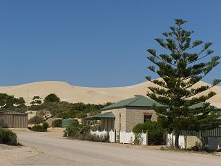
Port Gibbon consists of land on the coastline with Spencer Gulf which extends from a headland called Point Gibbon (formerly Point Price) in the south for a distance of about 5 kilometres (3.1 mi) along the southern end of an unnamed bay whose northern end terminates at a headland called The Knob in the adjoining locality of Cowell. The coastline consists of a series of beaches backing onto a cliff line of “red bluffs composed of Pleistocene alluvium” with heights up to 10 metres (33 ft). A settlement is located at the middle of the bay behind the cliff line. A road runs along the coast both south and north of the settlement. [12] [13] [14]

Land use in Port Gibbon is divided between primary industry, conservation and residential with the former being represented by “broadacre farming of cereals and livestock”, the second being represented by the zoning of the land adjoining the coastline with Spencer Gulf and the latter consisting of the settlement mentioned above. [15] [2]

Port Gibbon is located within the federal division of Grey, the state electoral district of Flinders and the local government area of the District Council of Franklin Harbour. [7] [6] [2]

Related Research Articles

Cape Jervis Town in South Australia

Cape Jervis is a town in the Australian state of South Australia located near the western tip of Fleurieu Peninsula on the southern end of the Main South Road approximately 88 kilometres (55 mi) south of the state capital of Adelaide.

Cowell, South Australia Town in South Australia

Cowell is a coastal town on Franklin Harbor on the eastern side of the Eyre Peninsula, in South Australia on the Lincoln Highway 111 km south of the major town of Whyalla. It is 493 km by road from Adelaide.

Haslam, South Australia Town in South Australia

Haslam is a town and a locality in the Australian state of South Australia located on the Eyre Peninsula on the coastline of Streaky Bay about 487 kilometres (303 mi) north-west of the state capital of Adelaide and about 32 kilometres (20 mi) north of the municipal seat of Streaky Bay.

Smoky Bay, South Australia Town in South Australia

Smoky Bay is a town and locality located in the Australian state of South Australia on the west coast of the Eyre Peninsula. Previously used as a port, the town is now a residential settlement and popular tourist destination known for its recreational fishing, with a boat ramp and jetty located in the town.

Fowlers Bay, South Australia Town in South Australia

Fowlers Bay, formerly Yalata, is a town and locality in the Australian state of South Australia located about 658 kilometres (409 mi) north-west of the state capital, Adelaide. Situated on the Nullarbor Plain, it was once an active port and a gateway to the western reaches of the continent, but fell into decline in the 1960s. At the 2016 census, the localities of Fowlers Bay and Coorabie shared a population of 51.

Inneston, South Australia South Australia

Inneston is a locality in the Australian state of South Australia located on the south-western end of Yorke Peninsula about 155 kilometres west of the state capital of Adelaide. Historically, it is notable as a site for the mining of gypsum and since 1970, the majority of the land within the current extent of the locality is within the protected area called the Innes National Park.

Sleaford, South Australia Suburb of District Council of Lower Eyre Peninsula, South Australia

Sleaford is a locality in the Australian state of South Australia located at the southern tip of the Eyre Peninsula overlooking the Great Australian Bight about 260 kilometres west of the state capital of Adelaide and about 17 kilometres west of the municipal seat of Port Lincoln.

Tulka, South Australia Suburb of District Council of Lower Eyre Peninsula, South Australia

Tulka is a locality in the Australian state of South Australia located on the southern tip of Eyre Peninsula overlooking the western end of the body of water known as Port Lincoln and which is located 259 kilometres west of the state capital of Adelaide and about 10 kilometres west of the city of Port Lincoln.

Black Point, South Australia Suburb of Yorke Peninsula Council, South Australia

Black Point is a locality in the Australian state of South Australia located on the east coast of Yorke Peninsula about 72 kilometres northwest of the state capital of Adelaide.

Laura Bay, South Australia Suburb of District Council of Ceduna, South Australia

Laura Bay is a locality in the Australian state of South Australia located on the west coast of the Eyre Peninsula overlooking the Great Australian Bight about 533 kilometres north-west of the Adelaide city centre and about 19 kilometres south east of the town centre of Ceduna.

Bookabie, South Australia Suburb of Pastoral Unincorporated Area, South Australia

Bookabie is a town and locality in the Australian state of South Australia located on the state’s west coast overlooking the Great Australian Bight about 648 kilometres north-west of the state capital of Adelaide and about 103 kilometres west of the town centre of Ceduna.

Myponga Beach, South Australia Suburb of District Council of Yankalilla, South Australia

Myponga Beach is a locality in the Australian state of South Australia located on the west coast of the Fleurieu Peninsula overlooking Gulf St Vincent about 54 kilometres south of the state capital of Adelaide.

Midgee, South Australia Suburb of District Council of Franklin Harbour, South Australia

Midgee is a locality in the Australian state of South Australia located on the east coast of Eyre Peninsula about 214 kilometres north-west of the state capital of Adelaide and about 37 kilometres north of the municipal seat of Cowell.

Mitchellville, South Australia Suburb of District Council of Franklin Harbour, South Australia

Mitchellville is a locality in the Australian state of South Australia located on the east coast of Eyre Peninsula about 198 kilometres north-west of the state capital of Adelaide and about 23 kilometres north of the municipal seat of Cowell.

Uley, South Australia Suburb of District Council of Lower Eyre Peninsula , South Australia

Uley is a locality in the Australian state of South Australia located at the southern tip of the Eyre Peninsula overlooking the body of water known as the Great Australian Bight about 273 kilometres (170 mi) west of the state capital of Adelaide and about 22 kilometres (14 mi) west of the city of Port Lincoln.

Farm Beach, South Australia Suburb of District Council of Lower Eyre Peninsula, South Australia

Farm Beach is a locality in the Australian state of South Australia located on the Eyre Peninsula in the state’s west overlooking the body of water known as Coffin Bay about 297 kilometres (185 mi) west of the state capital of Adelaide and about 40 kilometres (25 mi) south-west of the municipal seat of Cummins.

Little Douglas, South Australia Suburb of District Council of Lower Eyre Peninsula, South Australia

Little Douglas is a locality in the Australian state of South Australia located on the Eyre Peninsula in the state’s west overlooking the body of water known as Coffin Bay about 293 kilometres (182 mi) west of the state capital of Adelaide and about 42 kilometres (26 mi) south-west of the municipal seat of Cummins.

Kellidie Bay, South Australia Suburb of District Council of Lower Eyre Peninsula, South Australia

Kellidie Bay is a locality in the Australian state of South Australia located on the Eyre Peninsula in the state’s west overlooking parts of the body of water known as Coffin Bay about 290 kilometres (180 mi) west of the state capital of Adelaide and about 42 kilometres (26 mi) south-west of the municipal seat of Cummins.

Duck Ponds, South Australia Suburb of District Council of Lower Eyre Peninsula, South Australia

Duck Ponds is a locality in the Australian state of South Australia located on the Eyre Peninsula in the state's west about 258 kilometres (160 mi) west of the state capital of Adelaide, about 51 kilometres (32 mi) south of the municipal seat of Cummins and about 6 kilometres (3.7 mi) west of the city of Port Lincoln.

Eba Anchorage, South Australia Suburb of District Council of Streaky Bay, South Australia

Eba Anchorage is a locality in the Australian state of South Australia located in the state's west on the eastern shore of Streaky Bay on the west coast of the Eyre Peninsula about 469 kilometres (291 mi) north-west of the state capital of Adelaide and about 14 kilometres (8.7 mi) north-east of the municipal seat of Streaky Bay.

References

Notes
  1. For the 2011 census, the ‘State Suburb of Cowell’ consisted of the localities of Cowell and Port Gibbon. While the state suburb had a population of 1069, the ‘urban centre’ of Cowell has a population of 942 thereby leaving a population of 127 to be shared with Port Gibbon and those parts of Cowell located outside of the ‘urban centre’. [3]
Citations
  1. Australian Bureau of Statistics (31 October 2012). "Cowell". 2011 Census QuickStats. Retrieved 9 April 2017. OOjs UI icon edit-ltr-progressive.svg
  2. 1 2 3 4 5 6 7 8 9 "Search result for "Port Gibbon (Locality Bounded)" (Record no SA0040585) with the following layers being selected - "Suburbs and Localities", "Local Government Areas", "Development Plan Layers", "Place names (gazetteer)" and "Hundreds"". Property Location Browser. Government of South Australia. Archived from the original on 12 October 2016. Retrieved 9 April 2017.
  3. Australian Bureau of Statistics (31 October 2012). "Cowell (Urban Centre)". 2011 Census QuickStats. Retrieved 9 April 2017. OOjs UI icon edit-ltr-progressive.svg
  4. 1 2 3 "Port Gibbon, South Australia (Postcode)". postcodes-australia.com. Retrieved 9 April 2017.</}}
  5. "Eyre Western SA Government region" (PDF). The Government of South Australia. Retrieved 10 October 2014.
  6. 1 2 "District of Flinders Background Profile". Electoral Commission SA. Retrieved 9 September 2015.
  7. 1 2 "Federal electoral division of Grey" (PDF). Australian Electoral Commission. Retrieved 24 July 2015.
  8. "Monthly climate statistics: Summary statistics CLEVE AERODROME (nearest weather station)". Commonwealth of Australia , Bureau of Meteorology. Retrieved 9 April 2017.
  9. Collins, Neville C (2005), The jetties of South Australia : past and present, Neville Collins, pp. 75–77, ISBN   978-0-9580482-2-4
  10. "GEOGRAPHICAL NAMES ACT 1991, Notice to Assign Boundaries and Names to Places" (PDF). The South Australian Government Gazette. Government of South Australia: 2009. 23 December 1998. Retrieved 9 April 2017.
  11. "Place Names of South Australia - G". The Manning Index of South Australian History. State Library of South Australia. Retrieved 9 April 2017.
  12. "Port Gibbon (unpatrolled beach)". Beachsafe. Surf Life Saving Australia (SLSA). 28 August 2013. Retrieved 10 April 2017.
  13. "Search result for "Port Gibbon (Locality Bounded)" (Record no SA0040585) with the following data sets selected - "Suburbs and Localities" and "Gazetteer"". Location SA Map Viewer. Government of South Australia. Retrieved 10 April 2017.
  14. "WHAT'S IN A NAME?". Evening Journal (Adelaide) . XLIV (12108). South Australia. 21 January 1910. p. 2. Retrieved 10 April 2017 via National Library of Australia.
  15. "Development Plan, Franklin Harbour Council, Consolidated – 11 February 2016" (PDF). Government of South Australia. 2016. pp. 9, 112–113 and 230–232. Retrieved 10 April 2017.