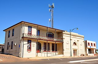
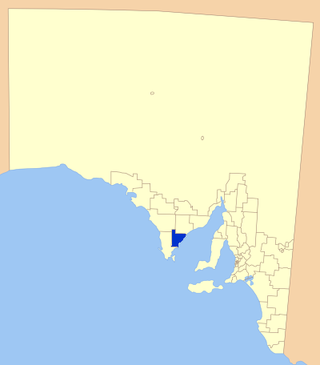
The District Council of Streaky Bay is a local government area in South Australia located on the Eyre Peninsula. Streaky Bay is the main population centre of about 1,200 people serving an agricultural district based on farming wheat and other cereal crops, sheep, supplemented by fishing and tourism industries. The district covers an area of 6,251.1 square kilometres with a population of 2,074 people in 2016, according to the Australian Bureau of Statistics. Mayor of Streaky Bay is Travis Barber.

Streaky Bay is a coastal town on the western side of the Eyre Peninsula, in South Australia just off the Flinders Highway, 303 km (188 mi) north-west of Port Lincoln and 727 km (452 mi) by road from Adelaide. At the 2016 census, Streaky Bay recorded a population of 1,378.

Sceale Bay is a small town 32 km south of Streaky Bay on the Eyre Peninsula of South Australia. With a permanent population of only 28, the town's numbers increase by threefold over the summer holiday period. The town is primarily an isolated holiday destination, with nothing in the way of commerce or industry occurring in its bounds.
Haslam is a town and a locality in the Australian state of South Australia located on the Eyre Peninsula on the coastline of Streaky Bay about 487 kilometres (303 mi) north-west of the state capital of Adelaide and about 32 kilometres (20 mi) north of the municipal seat of Streaky Bay.
The Tumby Bay District Council is a local government area of South Australia covering an area of the North Eastern Eyre Peninsula. It was established in 1906, only six years after the town of Tumby Bay was established, when the district was severed from the former District Council of Lincoln to form the present council.
Perlubie is a locality in the Australian state of South Australia located on the west coast of Eyre Peninsula about 472 kilometres (293 mi) north-west of the state capital of Adelaide and about 24 kilometres (15 mi) north-east of the municipal seat of Streaky Bay.
Poochera is a small grain belt town 60 km north-west of Streaky Bay on the Eyre Peninsula, South Australia.
Wirrulla is a small grain belt town located 60 km from Streaky Bay on the Eyre Peninsula. The town is a focus point for many of the surrounding agricultural districts, and features a number of silos used to store grain from the surrounding areas. The name of the town is derived from an Aboriginal word meaning "to make haste, to be quick".

Smoky Bay is a town and locality located in the Australian state of South Australia on the west coast of the Eyre Peninsula. Previously used as a port, the town is now a residential settlement and popular tourist destination known for its recreational fishing, with a boat ramp and jetty located in the town.
Denial Bay is a town and an associated locality in the Australian state of South Australia located on the state's west coast about 562 kilometres (349 mi) north-west of the state capital of Adelaide and about 10 kilometres (6.2 mi) west of the municipal seat of Ceduna. The town which is located on the western side of Murat Bay has extensive European history, first built on in 1889, and now hosts a large expanse of oyster farms, one of the largest on the Eyre Peninsula.
Mount Compass is a town and locality in the Australian state of South Australia located in the Mount Lofty Ranges, on the A13 south of Adelaide, and north of Victor Harbor. It is a small community, traditionally supported by farming. Both market gardens and dairy have proved lucrative in the area. At the 2016 census, Mount Compass shared a population of 1,457 with adjoining localities.
Calca is a small township around 20 kilometres (12 mi) south-east of Streaky Bay, on the southern border of the Calpatanna Waterhole Conservation Park, Eyre Peninsula.

Mortana is a rural locality in South Australia, located on the Eyre Peninsula. It is traversed by the Flinders Highway. The boundaries for the locality were established in April 2001 in respect of the long established local name.
Hincks is a locality in the Australian state of South Australia located on the Eyre Peninsula about 253 kilometres west of the state capital of Adelaide.

Sleaford is a locality in the Australian state of South Australia located at the southern tip of the Eyre Peninsula overlooking the Great Australian Bight about 260 kilometres west of the state capital of Adelaide and about 17 kilometres west of the municipal seat of Port Lincoln.
Pureba is a locality in the Australian state of South Australia located on the west coast of Eyre Peninsula and on land to the immediate north of the peninsula about 528 kilometres north-west of the state capital of Adelaide and about 52 kilometres north-east and 90 kilometres north respectively of the municipal seats of Ceduna and Streaky Bay.

Saltia is a locality in the Australian state of South Australia located on the western side of the Flinders Ranges about 279 kilometres (173 mi) north of the state capital of Adelaide and about 19 kilometres (12 mi) east of the city of Port Augusta.
Yantanabie is a town and rural locality in the wheat belt of South Australia, 37 miles inland from Streaky Bay, South Australia.

Johnburgh is a former town and a locality in the Australian state of South Australia located on the eastern side of the Flinders Ranges about 275 kilometres (171 mi) north of the state capital of Adelaide and about 32 kilometres (20 mi) north-east of the municipal seat of Orroroo.
Eba Anchorage is a locality in the Australian state of South Australia located in the state's west on the eastern shore of Streaky Bay on the west coast of the Eyre Peninsula about 469 kilometres (291 mi) north-west of the state capital of Adelaide and about 14 kilometres (8.7 mi) north-east of the municipal seat of Streaky Bay.

