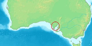
Lincoln National Park is a protected area in the Australian state of South Australia located about 249 kilometres (155 mi) west of the state capital of Adelaide and about 9.5 kilometres (5.9 mi) south of the municipal seat of Port Lincoln. It consists of a mainland area on the Jussieu Peninsula on the south eastern tip of Eyre Peninsula and a number of nearby islands. The national park contains significant sites of natural, indigenous and early European heritage.

The Spencer Gulf is the westernmost and larger of two large inlets on the southern coast of Australia, in the state of South Australia, facing the Great Australian Bight. It spans from the Cape Catastrophe and Eyre Peninsula in the west to Cape Spencer and Yorke Peninsula in the east.

Port Lincoln is a city on the Lower Eyre Peninsula in the Australian state of South Australia. It is situated on the shore of Boston Bay, which opens eastward into Spencer Gulf. It is the largest city in the West Coast region, and is located approximately 280 km as the crow flies from the State's capital city of Adelaide. In June 2019 Port Lincoln had an estimated population of 16,418, having grown at an average annual rate of 0.55% year-on-year over the preceding five years. The city is reputed to have the most millionaires per capita in Australia, as well as claiming to be Australia's "Seafood Capital".

Port Augusta is a small coastal city in South Australia about 310 kilometres (190 mi) by road from the state capital, Adelaide. Most of the city is on the eastern shores of Spencer Gulf, immediately south of the gulf's head, comprising the city's centre and surrounding suburbs, Stirling North, and seaside homes at Commissariat Point, Blanche Harbor and Miranda. The suburb of Port Augusta West is on the western side of the gulf on the Eyre Peninsula. Together, these localities had a population of 13,515 people in the 2021 census.

The Eyre Peninsula is a triangular peninsula in South Australia. It is bounded by the Spencer Gulf on the east, the Great Australian Bight on the west, and the Gawler Ranges to the north.

Tumby Bay is a coastal town situated on the Spencer Gulf, on the eastern coast of Eyre Peninsula in South Australia, 45 kilometres (28 mi) north of Port Lincoln. The town of Tumby Bay is the major population centre of the District Council of Tumby Bay, and the centre of an agricultural district farming cereal crops and sheep, as well as having established fishing and tourism industries.

Penneshaw is a township in the Australian state of South Australia located on the northeast coast of the Dudley Peninsula on Kangaroo Island about 107 kilometres (66 mi) south of the state capital of Adelaide. It is the island's main ferry port with regular services from Cape Jervis. Penneshaw features a Maritime and Folk Museum, and evening tours to a colony of little penguin, the only species of penguin to breed in Australian waters. At the 2011 census, Penneshaw had a population of 276.

Port Neill is a small coastal town on the eastern side of the Eyre Peninsula, in South Australia about 3 km off the Lincoln Highway between the major towns of Whyalla and Port Lincoln. It is 576 km by road from Adelaide.
Lipson is an historic farming town on the Eyre Peninsula, located only 12 km from Tumby Bay, South Australia. At the 2006 census, Lipson had a population of 209.
Thistle Island / Noondala is in the Spencer Gulf, South Australia, some 200 kilometres (120 mi) west of Adelaide, and northwest of the Gambier Islands. The city of Port Lincoln lies to the northwest of the island. Between them, the Gambier Islands and Thistle form a chain across the mouth of the gulf between the southern tips of the Yorke and Eyre Peninsulas, sometimes referred to as the Taylor Islands group.
Port Spencer is a proposed grain export port development project in South Australia. The project site, previously known as Sheep Hill, is on Lower Eyre Peninsula adjacent to Lipson Cove on the western shore of Spencer Gulf.

The Sir Joseph Banks Group is an archipelago in the Australian state of South Australia located in Spencer Gulf about 20 kilometres (12 mi) off the eastern coast of the Eyre Peninsula. It consists of 21 islands of which eighteen are in the Sir Joseph Banks Group Conservation Park while the surrounding waters are in the Sir Joseph Banks Group Marine Park. It is considered to be an important seabird breeding site.

Barngarla, formerly known as Parnkalla, is an Aboriginal language of Eyre Peninsula, South Australia, Australia. It was formerly extinct, but has been revived since 2012.
Cape Hardy is a 20 m (66 ft) high, dune-capped granite headland on the eastern coast of Eyre Peninsula and which protrudes into Spencer Gulf in South Australia. It is located between the towns of Port Neill and Tumby Bay, 10 km (6.2 mi) north-northeast of Lipson Cove.
Boston Island is a 960-hectare (2,400-acre) privately owned island in Boston Bay, Spencer Gulf, South Australia. It has been primarily used for grazing sheep and was also once the location of a proposed township called Kerrillyilla at the southern end of the island. In 2009, the island was rezoned to allow for future residential and tourism development. As of 2009, it is owned by the former mayor of Port Lincoln, Peter Davis. Davis' development plans include up to 1,000 residential allotments, three tourism developments and an inland marina. Prior to rezoning, there had been little interest expressed in the development plan, despite the then mayor's enthusiasm.
Hopkins Island is an island located in Spencer Gulf off the east coast of Jussieu Peninsula on Eyre Peninsula in South Australia approximately 32 km (20 mi) south-east of Port Lincoln. It was named by Matthew Flinders in memory of John Hopkins who was one of the eight crew lost from a cutter that capsized on 21 February 1802. Since 2004, the island has been part of the Memory Cove Wilderness Protection Area.

Dangerous Reef is an island and reef system located in the Spencer Gulf in the Australian state of South Australia about 32.5 kilometres (20.2 mi) east-southeast of the city, Port Lincoln. It is the southernmost member of the Sir Joseph Banks Group. It has been the site of a navigation aid since 1911. It is notable as the site of a breeding colony of Australian sea lions. The waters adjoining its shore are notable as a place to view great white sharks to the extent that it was both a popular gamefishing and shark cage diving venue during the twentieth century, and was used to film footage for the following motion pictures – Blue Water White Death and Jaws. The island has enjoyed protected area status since 1900 and it has been part of the Sir Joseph Banks Group Conservation Park since 1989.

Mount Dutton Bay is a coastal locality in the Eyre and Western region of South Australia, situated in the District Council of Lower Eyre Peninsula. The name and boundaries were formalised in October 2003 in respect of the long established local name which is derived from the body of water known as Mount Dutton Bay. The locality incorporates three older residential "shack sites": Mount Dutton Bay West, on Dolphin Drive, Mount Dutton Bay East, on Woolshed Drive, and Shelley Beach/Salt Creek, on Shelly Beach Road. It is part of the cadastral Hundred of Lake Wangary.
The Tod River is the only stream on Eyre Peninsula in South Australia with a reliable water flow. Its main tributary is Pillaworta Creek. The Tod River Reservoir was built across the river between 1918 and 1922.
Spilsby Island is one of the largest islands in the Sir Joseph Banks Group in Spencer Gulf, South Australia. It is privately owned, has no permanent human residents and is grazed by sheep. The island was used for the breeding of sheep by James Hunter Kerrison, then for the breeding of horses, sheep, pigs and cattle by W. E. Scruby in the early 20th century. Shearers travelled to the island to shear the sheep. The island's soil has been enriched by the deposition of guano by seabirds. Land allotments and a few shacks are concentrated along the northern coast of the island. Butterfish Bay is on the northern coast and Hawknest Bay is on the eastern coast.


