
Protected areas of South Australia consists of protected areas located within South Australia and its immediate onshore waters and which are managed by South Australian Government agencies. As of March 2018, South Australia contains 359 separate protected areas declared under the National Parks and Wildlife Act 1972, the Crown Land Management Act 2009 and the Wilderness Protection Act 1992 which have a total land area of 211,387.48 km2 (81,617.16 sq mi) or 21.5% of the state's area.

Lincoln National Park is a protected area in the Australian state of South Australia located about 249 kilometres (155 mi) west of the state capital of Adelaide and about 9.5 kilometres (5.9 mi) south of the municipal seat of Port Lincoln. It consists of a mainland area on the Jussieu Peninsula on the south eastern tip of Eyre Peninsula and a number of nearby islands. The national park contains significant sites of natural, indigenous and early European heritage.

The Spencer Gulf is the westernmost and larger of two large inlets on the southern coast of Australia, in the state of South Australia, facing the Great Australian Bight. It spans from the Cape Catastrophe and Eyre Peninsula in the west to Cape Spencer and Yorke Peninsula in the east.

The Eyre Peninsula is a triangular peninsula in South Australia. It is bounded on the east by Spencer Gulf, the west by the Great Australian Bight, and the north by the Gawler Ranges.

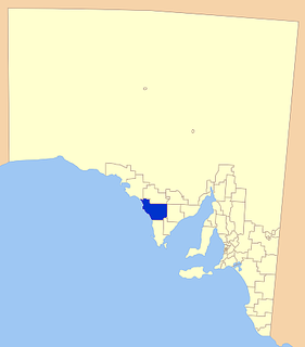
The District Council of Lower Eyre Peninsula is a local government area located on Eyre Peninsula in South Australia. The district covers the southern tip of the peninsula, except for the small area taken up by the City of Port Lincoln.
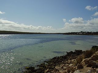
Coffin Bay, originally Coffin's Bay, is a town at the southern extremity of the Eyre Peninsula, a wheat growing area of South Australia. At the 2016 census, Coffin Bay had a population of 611.
The District Council of Elliston is a local government area covering around 6500 km2 on the Western Eyre Peninsula in South Australia. Established in 1888, the district has a diverse economy, with agriculture, commercial fishing and tourism making up the majority of the local economy.

Smoky Bay is a town and locality located in the Australian state of South Australia on the west coast of the Eyre Peninsula. Previously used as a port, the town is now a residential settlement and popular tourist destination known for its recreational fishing, with a boat ramp and jetty located in the town.
The Investigator Group is an archipelago in South Australia that consists of Flinders Island and five island groups located off the western coast of the Eyre Peninsula. It is named after HMS Investigator by her commander, Matthew Flinders when he explored the area in 1802. The Group lies within the Great Australian Bight. All the islands except Flinders Island, and a part of Pearson Island, are within the Investigator Group Wilderness Protection Area and the Waldegrave Islands Conservation Park.
Louth Bay is a town and locality in the Australian state of South Australia. It is named after the bay named by Matthew Flinders on 26 February 1802 which itself is derived from a place in Lincolnshire. At the 2006 census, Louth Bay had a population of 408.

The County of Flinders is one of the 49 cadastral counties of South Australia. The county covers the southern part of the Eyre Peninsula “bounded on the north by a line connecting Point Drummond with Cape Burr, and on all other sides by the seacoast, including all islands adjacent to the main land.”
Lucky Bay is a locality in the District Council of Franklin Harbour, on the Spencer Gulf coast of Eyre Peninsula in South Australia. It is a terminus for SeaSA's Spencer Gulf passenger ferry and a transshipping port for grain export operated by T-Ports. Lucky Bay is located immediately north-east of the Franklin Harbour wetlands. Its adjacent waters lie within the outer boundary of the Franklin Harbor Marine Park. A ferry service crossing Spencer Gulf from Lucky Bay to Wallaroo commenced in 2006, and the dirt road connecting Lucky Bay with the Lincoln Highway was sealed in 2008.
Goose Island is a small (2 ha), rocky island lying about 550 m from the northern end of the much larger Wardang Island, off the west coast of the Yorke Peninsula, in the Spencer Gulf of South Australia. Rising to a height of 26 m, its vegetation is dominated by African boxthorn on clay and calcarenite soils. The waters surrounding the island are protected in the Goose Island Aquatic Reserve. The island is leased from the Department of Environment, Water and Natural Resources by Scotch College and is co-managed by the two parties.
.

The Sir Joseph Banks Group is an archipelago in the Australian state of South Australia located in Spencer Gulf about 20 kilometres (12 mi) off the eastern coast of the Eyre Peninsula. It consists of 21 islands of which eighteen are in the Sir Joseph Banks Group Conservation Park while the surrounding waters are in the Sir Joseph Banks Group Marine Park. It is considered to be an important seabird breeding site.
Liguanea Island is an uninhabited granite island in the Australian state of South Australia located 3.7 km south of Cape Carnot at the southern, central point of Eyre Peninsula. It is approximately 2.7 km long, 180 ha in size its elevation above sea level is estimated to be 43 metres. It is approximately 35 km south-west of Port Lincoln in the Great Australian Bight. The island forms part of the Lincoln National Park.
Williams Island is an island in the Australian state of South Australia located off the south coast of Jussieu Peninsula on Eyre Peninsula approximately 34 km (21 mi) south-east of Port Lincoln. It was named by Matthew Flinders for Robert Williams who subsequently lost his life along with seven other crew in the capsize of a cutter launched from HM Sloop Investigator to search for water on 21 February 1802. Since 2004, the island has been part of the Memory Cove Wilderness Protection Area.
Hopkins Island is an island located in Spencer Gulf off the east coast of Jussieu Peninsula on Eyre Peninsula in South Australia approximately 32 km (20 mi) south-east of Port Lincoln. It was named by Matthew Flinders in memory of John Hopkins who was one of the eight crew lost from a cutter that capsized on 21 February 1802. Since 2004, the island has been part of the Memory Cove Wilderness Protection Area.
Owen Island, formerly known as Rabbit Island and also known as Little Taylor Island, is an island in the Australian state of South Australia located in Spencer Gulf off the east coast of Jussieu Peninsula on Eyre Peninsula approximately 18.7 kilometres (11.6 mi) south-east of Port Lincoln. Since 1972, the island has been part of the Lincoln National Park.
Torrens Island Conservation Park is a protected area in the Australian state of South Australia located on Torrens Island in the Adelaide metropolitan area about 17 kilometres north-northwest of the state capital of Adelaide and about 3.9 kilometres north-northeast of Port Adelaide.
