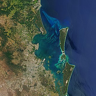
Curlew Island (South Australia)

Last updated

Curlew Island
Australia South Australia location map.svg
Red pog.svg
Curlew Island
Geography
Location Spencer Gulf
Coordinates 32°32′25″S137°46′18″E / 32.5404°S 137.7716°E / -32.5404; 137.7716 Coordinates: 32°32′25″S137°46′18″E / 32.5404°S 137.7716°E / -32.5404; 137.7716
Administration
Australia

Curlew Island is a low mangrove-dominated island located near the head of Spencer Gulf, South Australia. It lies between Port Augusta and Point Lowly and is adjacent to the Playford B Power Station. Several ships ran aground in the shallow waters surrounding the island during the late 1800s and early 1900s. Several recreational boating accidents have also occurred in the vicinity (some involving fatalities). The locality is known for its fishing and for occasional whale sightings in the winter.

Contents

History

In 1863, the island was described to mariners as "merely a large, thick patch of mangroves, separated from the point by a narrow channel, dry at low water... has a small sandy knoll at its north end, which only covers at high water springs." [1]

On 29 June 1882, the Government approved of a recommendation to construct a magazine for powder and a smaller one for dynamite at Port Augusta to be placed on Curlew Island. [2]

In July 1889, the first load of sea shells removed from Curlew Island was shipped to Port Pirie for use at the smelters. [3]

In 1932, the Port Augusta Yacht Club sailed to Curlew Island and held a picnic ashore there. [4] Picnics have been enjoyed there by many social groups, businesses and residents of nearby towns including Wilmington and Quorn. [5] Picnics were sometimes held to farewell a community member who was leaving the region.

In June 1950, the possibility of 'dredging away' Curlew Island was announced. A swinging basin was determined to provide deep-water access to the newly proposed northern power station. [6] Such a basin would allow ships to turn easily and unload equipment imported from England. [7]

Maritime incidents

Ship groundings

On 28 March 1878 the steamer Governor Musgrave en route to Port Augusta ran aground opposite Curlew Island. This prompted a request for a dredge to work in the channel. [8]

On 2 December 1885, the barque Sedwell Jane was aground at Curlew Island. [9]

On 14 March 1894, the steamer Melbourne, loaded with coal, ran aground at the Double Beacon near Curlew Island. [10]

Iron Monarch

Postcard of the merchant vessel Iron Monarch (formerly SS Koolonga) pre-1937. Iron Monarch pre-1937.jpg
Postcard of the merchant vessel Iron Monarch (formerly SS Koolonga) pre-1937.

On 18 February 1930 the Broken Hill Proprietary Company's steamer Iron Monarch ran aground on a sandbank inside No.6 Beacon near Curlew Island while en route to Port Augusta. She had aboard 6,500 tonnes of coal to deliver for the use of Commonwealth Railways. [11] After it was realized that the vessel would not float on the rising tide, tugs and barges were sent from Port Pirie to unload the cargo and transship it to its destination. After unloading 1,600 tonnes of cargo, [12] the vessel was freed on 27 February, only to demolish a beacon and strand again on another sand bank 18 kilometres (11 miles) out from Port Augusta (Commissariat Point). Once freed again with assistance from the tug Yacka, the vessel proceeded to Port Augusta to finish unloading its cargo. Its next consignment was to transport iron ore from Whyalla to Newcastle for steel-making. [13]

Boating accidents

Wildlife

The mangroves of Curlew Island provide habitat for cormorants. Cormorants were considered competition by fishermen in the early 1900s. They were deliberately culled in efforts to improve the abundance of fish in South Australian waters. [22] Humpback whales have been sighted by fishermen and coastal residents in the winter near Curlew Island. Southern right whales are also sighted, though less frequently. Whale sightings in the vicinity date back to 1894 [23] with the first humpback whale sighting reported in 1913. [24] A Bryde's whale was collected south of Curlew Island by a team from the South Australian Museum in April 1989. A baleen plate from the whale went on display at the museum in Adelaide in 2000. [25]

Fishing

Fishing for snapper is popular off Curlew Island. Snapper03 melb aquarium.jpg
Fishing for snapper is popular off Curlew Island.

The waters off Curlew Island have been popular among fishermen since the late 1800s. [17] Popular targeted fish include snapper and yellowtail kingfish. [26] Fishing grounds are accessible by boat by launching from Port Augusta or Point Lowly. In March 1904, fishermen reported having unusual trouble with sharks near Curlew Island. [27]

Related Research Articles

Spencer Gulf Large inlet in South Australia between the Eyre Peninsula and the Yorke Peninsula

The Spencer Gulf is the westernmost and larger of two large inlets on the southern coast of Australia, in the state of South Australia, facing the Great Australian Bight. It spans from the Cape Catastrophe and Eyre Peninsula in the west to Cape Spencer and Yorke Peninsula in the east.

The Eyre Peninsula is a triangular peninsula in South Australia. It is bounded by the Spencer Gulf on the east, by the Great Australian Bight on the west, and by the Gawler Ranges on the north.

Hamelin Bay, Western Australia Locality in Western Australia

Hamelin Bay is a bay and a locality on the southwest coast of Western Australia between Cape Leeuwin and Cape Naturaliste. It is named after French explorer Jacques Félix Emmanuel Hamelin, who sailed through the area in about 1801. It is south of Cape Freycinet.

Sea Shepherd Conservation Society operations Direct action marine conservation operations

The Sea Shepherd Conservation Society engages in various demonstrations, campaigns, and tactical operations at sea and elsewhere, including conventional protests and direct actions to protect marine wildlife. Sea Shepherd operations have included interdiction against commercial fishing, shark poaching and finning, seal hunting and whaling. Many of their activities have been called piracy or terrorism by their targets and by the ICRW. Sea Shepherd says that they have taken more than 4,000 volunteers on operations over a period of 30 years.

SS <i>Great Republic</i> (1866)

SS Great Republic was a sidewheel steamship and the largest passenger liner on the US west coast when it ran aground near the mouth of the Columbia River, on Sand Island, south of Ilwaco, Washington, in 1879, in a region of frequent wrecks known as the Graveyard of the Pacific.

HMAS <i>Koolonga</i>

HMAS Koolonga was a 4,260 gross register tons cargo ship built by Sunderland Shipbuilding Company, South Dock Sunderland, England, in 1914 and bought by McIlwraith, McEacharn Line Pty Ltd, Melbourne and named SS Koolonga. She was requisitioned by the Royal Australian Navy on 6 August 1914, as a collier and supply ship. She was returned to her owners in late 1915. She was sold in 1937 to Madrigal & Company, Philippines and renamed Paz. She was scuttled during the Second World War at Sourabaya Harbour in 1942 and was later salvaged by the Imperial Japanese and renamed Hatsu Maru. While at anchor in Manila Bay, Philippines on 13 November 1944, she was attacked by United States Navy carrier aircraft and was sunk.

<i>Ellen</i> (1883)

Ellen was a steamship that was launched in 1883 and whose career involved coastal shipping firstly in the Colony of Queensland and then in the Australian state of South Australia. It was wrecked in Gulf St Vincent in South Australia at Morgan's Beach near the town of Cape Jervis on Saturday, 12 December 1908 during its return from fishing in waters around Kangaroo Island to a destination on the mainland.

Tumby Island is a low bedrock island located 500 m east of the southern tip of Tumby Bay in Spencer Gulf, South Australia. The island is a conservation park comprising 35 hectares. The island can be accessed on foot at low tide by traversing shallow water-covered rock flats and curving sand. Visitors should request access permission from DEWNR before visiting and be mindful of the presence of Death adders.

Louth Island

Louth Island is a 135 ha island located in Louth Bay, Spencer Gulf, South Australia. The island is privately owned, and has previously been used for the grazing of sheep and mining of guano. The island has an old building with sleeping quarters, several beaches, inshore rocky reef and a boat anchorage. It is 17.5 km NNE of Port Lincoln and is easily accessible by boat. The indigenous name for the island is Yorunu.

Grantham Island is an uninhabited island occupying 51 ha of Proper Bay, Spencer Gulf, South Australia. The nearest geographical feature on the mainland is Murray Point, which is also undeveloped. The island was named by explorer Matthew Flinders on 25 February 1802, after the municipal and parliamentary borough of Grantham, Lincolnshire, England. It lies 3 km south of the Port Lincoln marina and is well vegetated.

Boston Island is a 960-hectare (2,400-acre) privately owned island in Boston Bay, Spencer Gulf, South Australia. It has been primarily used for grazing sheep and was also once the location of a proposed township called Kerrillyilla at the southern end of the island. In 2009, the island was rezoned to allow for future residential and tourism development. As of 2009, it is owned by the former mayor of Port Lincoln, Peter Davis. Davis' development plans include up to 1,000 residential allotments, three tourism developments and an inland marina. Prior to rezoning, there had been little interest expressed in the development plan, despite the then mayor's enthusiasm.

Shark attacks in South Australia

As of 2014, there have been 82 recorded shark attacks in South Australia since the establishment of the colony in 1836. 20 of those have involved a single fatality. Victims were involved in a range of aquatic activities, including surfing, diving, spear-fishing, snorkeling, boating and swimming. Six of the fatalities occurred off the coast of greater metropolitan Adelaide, with the remainder distributed across South Australia's extensive coastline. Many of the fatal attacks have been attributed to Great white sharks.

1804 Antigua–Charleston hurricane Hurricane in 1804

The 1804 Antigua–Charleston hurricane was the most severe hurricane in the American state of Georgia since 1752, causing over 500 deaths and at least $1.6 million (1804 USD) in damage throughout the Southeastern United States. Originating near Antigua on 3 September, it initially drifted west-northwestward, soon nearing Puerto Rico. Throughout its existence in the Caribbean Sea, the hurricane damaged, destroyed, and capsized numerous ships, and at Saint Kitts, it was considered to be the worst since 1772. By 4 September, the storm arrived at the Bahamas and turned northward before approaching the coast of northern Florida on 6 September. The hurricane eventually came ashore along the coastline of Georgia and South Carolina while producing mostly southeasterly winds. A severe gale was noted in New England later that month, on 11 and 12 September, although it was likely not the same system as that which had passed through the Caribbean and southeastern United States earlier that month.

John Ralph Hansford Ward, invariably known as Hansford Ward or Captain Ward, was a ship's captain in South Australia, who figures prominently in the pre-history of the Adelaide Steamship Company. A son, also named John Ralph Hansford Ward but known as John R. H. Ward, was also a ship's captain.

Sixty-miler

Sixty-miler (60-miler) is the colloquial name for the ships that were used in the coastal coal trade of New South Wales, Australia. The sixty-milers delivered coal to Sydney Harbour from ports and ocean jetties to the north and south of Sydney. The name refers to the approximate distance by sea from the Hunter River to Sydney.

Stone Fleet (New South Wales)

The Stone Fleet was the colloquial name for the small coastal ships that carried crushed-stone construction aggregate to Sydney from the Illawarra ports of Kiama and Shellharbour and the nearby ocean jetties at Bombo and Bass Point. The coastal shipping trade carried on by these ships was known colloquially as the 'Stone Trade' or 'Blue Diamond Trade'. The trade ended finally in 2011.

References

  1. "Nautical description of Port Augusta, South Australia" Sydney Morning Herald, New South Wales (1863-02-02). Retrieved 2014-01-17.
  2. "Marine Board. Thursday, June 29" South Australian Register, South Australia (1882-06-30). Retrieved 2014-01-17.
  3. "Country Telegrams - Port Augusta" The Advertiser, South Australia (1889-07-20). Retrieved 2014-01-17.
  4. "Yachting at Port Augusta" Chronicle, South Australia (1923-03-10). Retrieved 2014-01-17.
  5. "A Gulf Picnic" Chronicle, South Australia (1926-03-20). Retrieved 2014-01-18.
  6. "Survey for new wharf" News, South Australia (1950-06-14). Retrieved 2014-01-17.
  7. "Dredge has powerhouse foundations" News, South Australia (1951-02-05). Retrieved 2014-01-17.
  8. "Accidents, Offences &c" South Australian Chronicle & Weekly Mail, South Australia (1878-04-06). Retrieved 2014-01-17.
  9. "Port Augusta" South Australian Register, South Australia (1885-12-02). Retrieved 2014-01-17.
  10. "The steamer Melbourne - aground at Curlew Island" The Advertiser (1894-03-15). Retrieved 2014-01-17.
  11. "Iron Monarch Aground - Cargo to be transshipped" News, South Australia (1930-02-20). Retrieved 2014-01-17.
  12. "Iron Monarch Refloating Attempt Fails" Newcastle Morning Herald & Miner's Advocate, New South Wales (1930-02-27). Retrieved 2014-01-17.
  13. "Iron Monarch Floated Off Bank - Reported Undamaged" News, South Australia (1930-02-27). Retrieved 2014-01-17.
  14. "News of the Week" South Australian Chronicle & Weekly Mail, South Australia (1881-01-22). Retrieved 2014-01-17.
  15. "Port Augusta" South Australian Register, South Australia (1883-02-19). Retrieved 2014-01-17.
  16. "Narrow escape from drowning" South Australian Register, South Australia (1883-02-22). Retrieved 2014-01-18.
  17. 1 2 "Coroner's Inquest. Fatal Boat Accident" South Australian Register, South Australia (1886-03-16). Retrieved 2014-01-17.
  18. "Fatal boating accident at Port Augusta" South Australian Weekly Chronicle, South Australia (1887-06-11). Retrieved 2014-01-17.
  19. "Terrible boating fatality. Three lives lost." The Inquirer & Commercial News, Western Australia (1896-04-03). Retrieved 2014-01-17.
  20. "Body of man found in sea" The Advertiser, South Australia (1946-04-09). Retrieved 2014-01-17.
  21. "Diplomats on the wharf" Chronicle, South Australia (1946-04-18). Retrieved 2014-01-17.
  22. "Correspondence - G.Marks" The Advertiser, South Australia (1904-02-12). Retrieved 2014-01-17.
  23. "Country News. Port Augusta" South Australian Register, South Australia (1894-11-06). Retrieved 2014-01-17.
  24. "PORT AUGUSTA" The Register, South Australia (1913-08-11). Retrieved 2014-01-17.
  25. Occurrence record- Mammalogy M15373 Atlas of Living Australia. Accessed 2014-01-17.
  26. "Angling and Fishing - Port Augusta Correspondent" The Mail, South Australia (1926-02-13). Retrieved 2014-01-17.
  27. "Port Augusta" Chronicle, South Australia (1904-04-02). Retrieved 2014-01-17.