
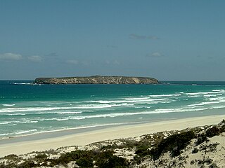
The Spencer Gulf is the westernmost and larger of two large inlets on the southern coast of Australia, in the state of South Australia, facing the Great Australian Bight. It spans from the Cape Catastrophe and Eyre Peninsula in the west to Cape Spencer and Yorke Peninsula in the east.

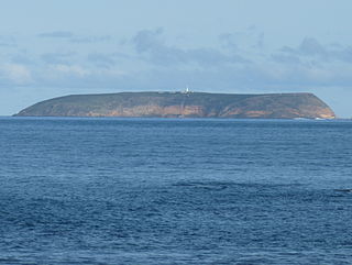
The Neptune Islands consist of two groups of islands located close to the entrance to Spencer Gulf in South Australia. They are well known as a venue for great white shark tourism.
Sibsey Island is an island in the Australian state of South Australia located in Spencer Gulf within the Sir Joseph Banks Group. It was discovered on 21 February 1802 by Matthew Flinders. Currently, the island is uninhabited.

Seal Bay Conservation Park is a protected area located on the south coast of Kangaroo Island in the Australian state of South Australia. It is the home of the third largest Australian sea lion colony in Australia.

Pullen Island is a 1 ha granite island lying 0.5 km offshore from the town of Port Elliot on the southern coast of the Fleurieu Peninsula of South Australia. It was originally named Lipson Island but was renamed in 1839 by W.J.S. Pullen, the Colonial Marine Surveyor, after himself. The island is protected by designation as the Pullen Island Conservation Park.
Liguanea Island is an uninhabited granite island in the Australian state of South Australia located 3.7 km south of Cape Carnot at the southern, central point of Eyre Peninsula. It is approximately 2.7 km long, 180 ha in size its elevation above sea level is estimated to be 43 metres. It is approximately 35 km south-west of Port Lincoln in the Great Australian Bight. The island forms part of the Lincoln National Park.
The Althorpe Islands are a group of islands in the Investigator Strait, off the south-western tip of Yorke Peninsula, South Australia. The group includes Althorpe Island and two rocky islets immediately to its west known as The Boobs. These are located 7.7 km south-southwest of Cape Spencer on the mainland. Closer inshore are Seal Island and Haystack Island, which together with Althorpe Island and The Boobs constitute the Althorpe Islands Conservation Park. A management plan for the Althorpe Islands Conservation Park was adopted in 2009. The islands are uninhabited and can only be accessed by sea or by helicopter.

Greenly Island is an island in the Australian state of South Australia located in the Great Australian Bight about 30 kilometres (19 mi) west-south-west of Point Whidbey on Eyre Peninsula. The island is uninhabited by humans and provides a haven for marine and terrestrial wildlife. The island and its intertidal zone constitute the Greenly Island Conservation Park. Its adjacent waters are occasionally visited by fishermen targeting yellowtail kingfish.
Little Island is an island in the Australian state of South Australia located in Spencer Gulf off the east coast of Jussieu Peninsula on Eyre Peninsula approximately 28 kilometres (17 mi) south-east of Port Lincoln. It was named by Matthew Flinders in memory of John Little who was one of the eight crew lost from a cutter that capsized sometime after being launched from HM Sloop Investigator to search for water on 21 February 1802. Since 2004, the island has been part of the Memory Cove Wilderness Protection Area.
Smith Island is an island located in Spencer Gulf off the east coast of Jussieu Peninsula on Eyre Peninsula in South Australia approximately 32 km (20 mi) south-east of Port Lincoln. It was named by Matthew Flinders in memory of William Smith who was one of the eight crew lost from a cutter that capsized sometime after being launched from HM Sloop Investigator to search for water on 21 February 1802. Since 2004, the island has been part of the Memory Cove Wilderness Protection Area.
Lewis Island is an island located in Spencer Gulf off the east coast of Jussieu Peninsula on Eyre Peninsula in South Australia approximately 29 km (18 mi) south-east of Port Lincoln. It was named by Matthew Flinders in memory of George Lewis who was one of the eight crew lost from a cutter that capsized sometime after being launched from HM Sloop Investigator to search for water on 21 February 1802. Since 2004, the island has been part of the Memory Cove Wilderness Protection Area.
Hopkins Island is an island located in Spencer Gulf off the east coast of Jussieu Peninsula on Eyre Peninsula in South Australia approximately 32 km (20 mi) south-east of Port Lincoln. It was named by Matthew Flinders in memory of John Hopkins who was one of the eight crew lost from a cutter that capsized on 21 February 1802. Since 2004, the island has been part of the Memory Cove Wilderness Protection Area.

Nobby Islet is an islet located in the Great Australian Bight off the south coast of Kangaroo Island in the Australian state of South Australia approximately 50 kilometres south-west of Kingscote. It is currently part of the Seal Bay Conservation Park.
The Whidbey Isles Conservation Park is a protected area in the Australian state of South Australia which consists of seven islands located about 15 kilometres (9.3 mi) west-southwest of Coffin Bay on the lower Eyre Peninsula.
Gambier Islands Conservation Park is a protected area associated with the Gambier Islands Group which is located in the middle of the mouth of Spencer Gulf in South Australia about 71 kilometres south east of Port Lincoln. The conservation park consists of the following islands from within the group - North Island, South West Rock and Peaked Rocks. Wedge Island is not included in the conservation park. The land which now comprises the conservation park was previously declared as Fauna Reserves in March 1967 under the Fauna Conservation Act 1964 and was re-proclaimed in 1972 under the National Parks and Wildlife Act 1972. The area under protection is considered significant for the following reasons: 'a group of small islands utilised by seabirds and the Australian sea lion' and the 'North Island supports a population of the southern bush rat .' The conservation park is classified as an IUCN Category Ia protected area.
Lipson Island Conservation Park is a protected area in the Australian state of South Australia associated with Lipson Island in Spencer Gulf about 12 kilometres north northeast of Lipson.
Smooth Island is an island in the Australian state of South Australia located off the west coast of Eyre Peninsula about 52 kilometres south west of the town of Ceduna. It is both part of a local group of islands known as the Isles of St Francis group and a larger group known as the Nuyts Archipelago. It has enjoyed protected area status since the 1960s and since 2011, it has been part of the Nuyts Archipelago Wilderness Protection Area.
Jones Island is an island in the Australian state of South Australia located at the mouth of Baird Bay in the north end of Anxious Bay about 45 kilometres south-southeast of the town of Streaky Bay on the west coast of Eyre Peninsula. The island is notable as a breeding site for Australian sea lions and Australian pelicans. The island has enjoyed protected area status since 1967 and as of 1972, it has been part of the Baird Bay Islands Conservation Park.
Royston Island is an island in the Australian state of South Australia at the northern end of Pondalowie Bay on the south-west extremity of Yorke Peninsula about 13 kilometres north-west of the town of Stenhouse Bay. The island has enjoyed protected area status since 1967 and since 1972, it has been part of the Innes National Park.

South Island is an island located in the Australian state of South Australia at the south end of Pondalowie Bay on the south-west extremity of Yorke Peninsula about 11 kilometres north-west by west of the town of Stenhouse Bay. The island has enjoyed protected area status since 1970 and since 1977, it has been part of the Innes National Park.
