Port Giles, South Australia

Last updated

Port Giles
Coobowie,  South Australia
Port Giles silos.jpg
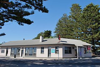
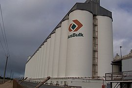
Grain silos at Port Giles
Australia South Australia location map.svg
Red pog.svg
Port Giles
Coordinates 35°01′23″S137°45′34″E / 35.023105°S 137.759314°E / -35.023105; 137.759314 Coordinates: 35°01′23″S137°45′34″E / 35.023105°S 137.759314°E / -35.023105; 137.759314 [1]
Established28 May 1970 [2]
Location3 km (2 mi) south of Town of Wool Bay

Port Giles is a port on Yorke Peninsula in the Australian state of South Australia located in the gazetted locality of Coobowie between the towns of Stansbury and Edithburgh. [1]

Yorke Peninsula Region in South Australia

The Yorke Peninsula is a peninsula located north-west and west of Adelaide in South Australia, between Spencer Gulf on the west and Gulf St Vincent on the east. The peninsula is separated from Kangaroo Island to the south by Investigator Strait. The most populous town in the region is Kadina.

South Australia State of Australia

South Australia is a state in the southern central part of Australia. It covers some of the most arid parts of the country. With a total land area of 983,482 square kilometres (379,725 sq mi), it is the fourth-largest of Australia's states and territories by area, and fifth largest by population. It has a total of 1.7 million people, and its population is the second most highly centralised in Australia, after Western Australia, with more than 77 percent of South Australians living in the capital, Adelaide, or its environs. Other population centres in the state are relatively small; Mount Gambier, the second largest centre, has a population of 28,684.

Stansbury, South Australia Town in South Australia

Stansbury is a small town, located in the southern east coast of Yorke Peninsula, South Australia. At the 2016 census, Stansbury had a population of 648 people. It is located 25 kilometres (16 mi) south of Minlaton and 22 kilometres (14 mi) east of Yorketown. It faces the Gulf St Vincent across Oyster Bay, where shellfish were originally harvested in the 19th century. The town has also been a port used in the export of wheat and barley to Adelaide.

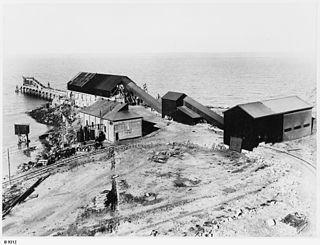
Port Giles is not a town, but a port facility consisting of a large jetty equipped for bulk handling of grain which is operated by Flinders Ports, [3] and a similarly large grain storage facility operated by ABB Grain. It was opened by the then Premier of South Australia, Steele Hall in 1970, and led to the closure of many of the smaller ports on the peninsula. Port Giles can handle Panamax size ships or larger. [4]

Flinders Ports manages seven of South Australia's ten privately owned ports and is the state's largest port operator.

Premier of South Australia Wikimedia List

The Premier of South Australia is the head of government in the state of South Australia, Australia. The Government of South Australia follows the Westminster system, with a Parliament of South Australia acting as the legislature. The Premier is appointed by the Governor of South Australia, and by modern convention holds office by virtue of his or her ability to command the support of a majority of members of the lower house of Parliament, the House of Assembly.

Steele Hall Australian politician

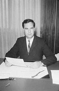
Raymond Steele Hall was the 36th Premier of South Australia 1968–70, a senator for South Australia 1974–77, and federal member for the Division of Boothby 1981–96.

Port Giles was deliberately built to be able to handle bulk grain, and load it onto larger modern ships. Many of the other ports were not deep enough for larger ships, and could only be serviced by small ketches and coastal steamships. They only handled grain in bags, not in bulk.

Ketch type of sailing boat

A ketch is a two-masted sailing craft whose mainmast is taller than the mizzen mast. The name "ketch" is derived from "catch" or fishing boat.

See also

Related Research Articles

Lincoln National Park Protected area in South Australia

Lincoln National Park is a protected area in the Australian state of South Australia located about 249 kilometres (155 mi) west of the state capital of Adelaide and about 9.5 kilometres (5.9 mi) south of the municipal seat of Port Lincoln. It consists of a mainland area on the Jussieu Peninsula on the south eastern tip of Eyre Peninsula and a number of nearby islands. The national park contains significant sites of natural, indigenous and early European heritage.

Eyre Peninsula South Australia

The Eyre Peninsula is a triangular peninsula in South Australia. It is bounded on the east by Spencer Gulf, the west by the Great Australian Bight, and the north by the Gawler Ranges.

Port River River in Australia

The Port River is part of a tidal estuary located north of the Adelaide city centre in the Australian state of South Australia, and used as a shipping channel since the beginning of European settlement in 1836.

Cummins, South Australia Town in South Australia

Cummins is a town on Eyre Peninsula in South Australia, 67 km north of Port Lincoln and 68 m above sea level. At the 2011 census, the town had a population of 719.

Thevenard, South Australia Town in South Australia

Thevenard is a port town 3 kilometres (1.9 mi) south-west of Ceduna, South Australia. It is named after nearby Cape Thevenard, which in turn had been named after Antoine-Jean-Marie Thévenard, a French admiral. At the 2006 census, Thevenard had a population of 776.

Ardrossan, South Australia Town in South Australia

Ardrossan is a town in the Australian state of South Australia located on the east coast of the Yorke Peninsula, about 150 kilometres (93 mi) by road from the Adelaide city centre, It is notable for its deepwater shipping port and its towering coastal cliffs of red clay.

Tumby Bay, South Australia Town in South Australia

Tumby Bay is a coastal town situated on the Spencer Gulf, on the eastern coast of Eyre Peninsula in South Australia, 45 kilometres (28 mi) north of Port Lincoln. The town of Tumby Bay is the major population centre of the District Council of Tumby Bay, and the centre of an agricultural district farming cereal crops and sheep, as well as having established fishing and tourism industries.

Port Neill, South Australia Town in South Australia

Port Neill is a small coastal town on the eastern side of the Eyre Peninsula, in South Australia about 3 km off the Lincoln Highway between the major towns of Whyalla and Port Lincoln. It is 576 km by road from Adelaide.

Wool Bay, South Australia Town in South Australia

Wool Bay is a locality and a former government town in the Australian state of South Australia on the east coast of southern Yorke Peninsula. It is located between Stansbury and Coobowie on Yorke Peninsula, approximately 220 kilometres from Adelaide by road, but only just over 60km due west across Gulf St Vincent.

Poochera, South Australia Town in South Australia

Poochera is a small grain belt town 60 km north-west of Streaky Bay on the Eyre Peninsula, South Australia.

Smoky Bay, South Australia Town in South Australia

Smoky Bay is a town and locality located in the Australian state of South Australia on the west coast of the Eyre Peninsula. Previously used as a port, the town is now a residential settlement and popular tourist destination known for its recreational fishing, with a boat ramp and jetty located in the town.

Port Victoria Maritime Museum

Port Victoria Maritime Museum is a maritime museum in the Australian state of South Australia located on the west coast of Yorke Peninsula in Port Victoria. It is housed in the original general cargo shed which was brought out from England in kit form in 1877 and was erected at the landward end of the jetty. The jetty took only seven months to build and was completed in January 1878. Household goods for the early settlers in the town and surrounding farmlands were brought by steamers from Port Adelaide and stored in the cargo shed until the settlers’ homes were completed.

Transport in South Australia is provided by a mix of road, rail, sea and air transport. The capital city of Adelaide is the centre to transport in the state. With its population of 1.4 million people, it has the majority of the state's 1.7 million inhabitants. Adelaide has the state's major airport and sea port.

Murdinga, South Australia Town in South Australia

Murdinga is a locality in South Australia located on the Eyre Peninsula about 297 kilometres (185 mi) west of the state capital of Adelaide. The name reportedly stems from an Aboriginal word for "cold".

Klein Point South Australia

Klein Point is a headland in the Australian state of South Australia located about 7 kilometres south of Stansbury in the locality of Wool Bay on Yorke Peninsula. It is the site of a port facility established to handle shipments of limestone for Adelaide Brighton Cement. The port is managed by Flinders Ports. Prior to 1965 it was known as Farquhar Jetty.

Edillilie, South Australia Town in South Australia

Edillilie is a small town on Eyre Peninsula in South Australia. It is on the Tod Highway and Eyre Peninsula Railway north of Port Lincoln.

Port Gibbon, South Australia Suburb of District Council of Franklin Harbour, South Australia

Port Gibbon is a locality in the Australian state of South Australia located on the east coast of Eyre Peninsula about 208 kilometres north-west of the state capital of Adelaide and about 17 kilometres south-west of the municipal seat in Cowell.

Stephenston, South Australia Suburb of Flinders Ranges Council , South Australia

Stephenston is a locality in the Australian state of South Australia located on the eastern side of the Flinders Ranges about 285 kilometres (177 mi) north of the state capital of Adelaide and about 15 kilometres (9.3 mi) east of the municipal seat of Quorn.

References

  1. 1 2 "Search result for 'Port Giles, Locu' with the following datasets selected - 'Suburbs and Localities', 'Government Towns' and 'Gazetteer'". Location SA Map Viewer. South Australian Government. Retrieved 26 April 2018.
  2. Rodda, W. Allen (28 May 1970). "HARBORS ACT, 1936-1969: NOTICE OF DECLARATION OF PORT FACILITIES—PORT GILES" (PDF). The South Australian Government Gazette. The Government of South Australia. p. 1977. Retrieved 7 May 2019.
  3. "Port Giles". Flinders Ports. Retrieved 30 October 2014.
  4. Infrastructure Australia Archived 11 February 2014 at the Wayback Machine